Potential for Widespread Severe Storms Today

There is strong potential for widespread severe weather today, primarily from a squall line, with damaging winds, a few embedded tornadoes, and some discrete supercells out ahead of the squall line that may also produce a few tornadoes. The SPC continues its moderate risk for severe weather, with 45% hatched for winds, 10% for tornadoes, and 15% for hail.

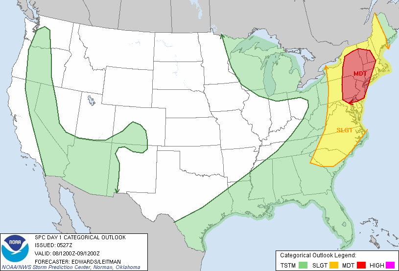
Not much has changed since the event overview post from yesterday morning. However, one thing to note is that at 500mb, the shortwave energy and area of vorticity appears to escape to the northeast a bit quicker than previous runs. Instead of the strongest area of vorticity being in Pennsylvania at 00z, Sunday, it is now located in NW Upstate NY. This will result in some of the best shear escaping to the northeast a bit faster, and not extending as far to the south into New Jersey.

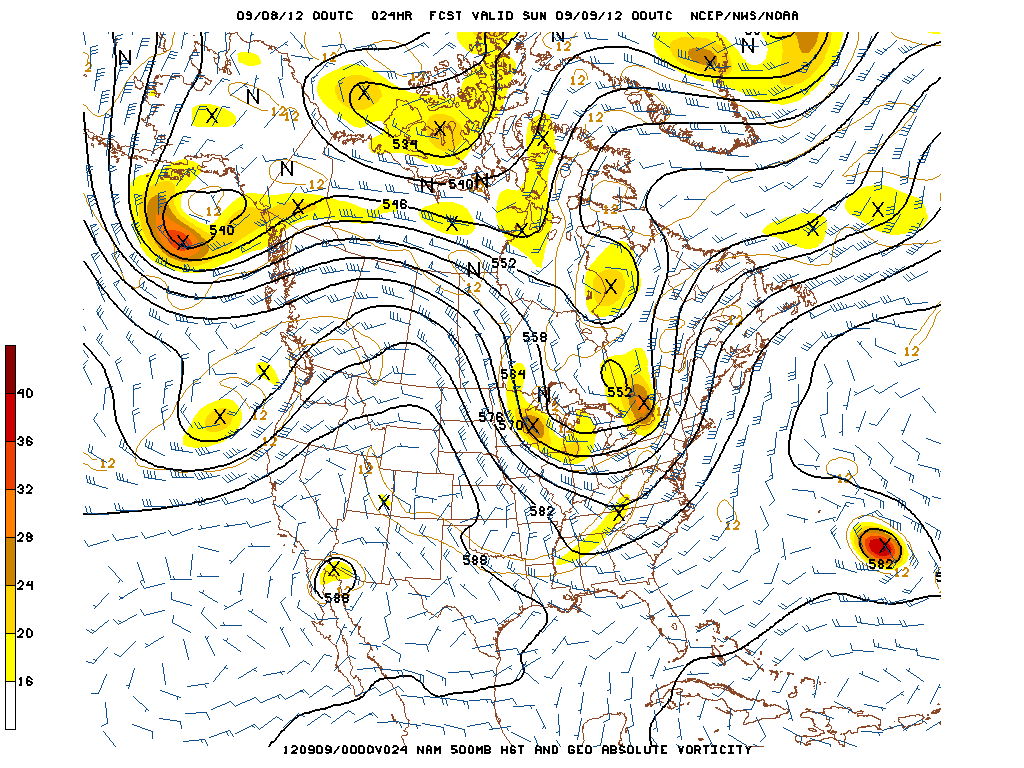
00z NAM 500mb Forecast, Valid 00z Sunday, September 9th, or 8pm EDT Saturday, September 8th

That being said, it is still a very impressive synoptic setup with lots of large-scale ascent from a potent trough swinging to the east, creating height falls and very fast mid and upper level winds with strong 250mb divergence. Most of the northeast will be in the right entrance region of the jet, also promoting large-scale ascent. Additionally, the large trough and storm system will help to promote strong southerly flow at the surface, helping to advect rich low-level moisture, with dewpoints in the low 70s. Some areas will see a SE flow, but considering how warm the ocean is in the early fall, the ocean provides a good moisture source without providing much in the way of stabilization.


Read more

Storm Prediction Center issues Day 2 Moderate Risk for Northeast

In anticipation of a potential widespread severe weather event throughout the Northeast United States, the Storm Prediction Center has issued a rare “Moderate Risk” for severe thunderstorms that includes all of the New York City area as well as

Storm Prediction Center Day 2 Categorical Outlook (Valid for Saturday) showing a “Moderate Risk” over the Northeast US.

New Jersey, Southeast New York and Connecticut. The outlook mentions the potential for “widespread damaging winds” as well as the potential for “a few tornadoes” in the Moderate Risk area, specifically over Northern New Jersey into Southeast and Eastern New York. Ahead of a cold front, an unstable airmass is expected to work in tandem with strong wind shear in the atmosphere to produce a line of strong and severe thunderstorms Saturday afternoon over parts of Pennsylvania and New York that will eventually shift east through New Jersey, New York City and the coastal Northeast. For more on the threat, you can check out our event overview post from this morning , but be sure to also follow us on Twitter and Facebook for the latest real-time updates as we draw closer to Saturday.

What caused the tornado warnings in New Jersey on Tuesday?

RAP 850mb Analysis for 00z Wednesday, September 5th or 8pm EDT Tuesday, September 4th 2012.

“Tornado Warning” has always been an ominous phrase. When you hear those words, things generally tend to get a little more serious. On Tuesday, there were more than three Tornado Warnings issued throughout the state of New Jersey, beginning in the afternoon and continuing into the evening hours. Although the area did not see much in the way of severe weather reports in a quantitative sense, there were several reports of low-level mesocyclones, funnel clouds, and even tornadoes in the general extreme Eastern PA and NJ areas. In hindsight, this was actually a pretty good setup for low-level mesocyclones and tornadoes, and I’ll explain why.

Synoptically, we had a surface low that slowly deepened to around 1006mb located in Western Upstate New York, along with a closed 850mb low located in the same area. This placed our area in a pressure trough, and also resulted in a warm front that moved to the north across our region. Warm fronts are generally a better lifting mechanism for rotating thunderstorms than cold fronts. This closed 850mb low helped to provide a nice low-level jet, as 850mb winds were around 30 knots in most locations.

Additionally, there was some helicity as well, which is an indicator of rotation in the low levels of the atmosphere. What is also interesting to note is the light SE surface winds, and the importance of that will be explained in a bit. Click “Read More” below to read the full article..

Read more

Scattered strong storms possible again today

A cold front near the area will once again serve as a focal point for the development of numerous showers and thunderstorms this Saturday afternoon. The Storm Prediction Center has placed our area in a risk area (not quite “Slight Risk”, this time) for potential isolated severe weather. The main threats, again, look to be very heavy rain in any storms as well as the potential for lightning and isolated damaging wind gusts in storms that are able to maintain their strength. You can check out the Storm Prediction Center’s technical discussion by clicking here. Pinning down exactly where the heaviest rain will be, or most widespread storms will form is nearly impossible at this range. But it does appear that most in our area should at least see some activity today. Stay tuned to our Twitter account for live updates on the event during the day today.