Strong thunderstorms with isolated tornadoes tonight

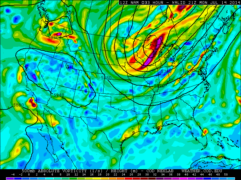
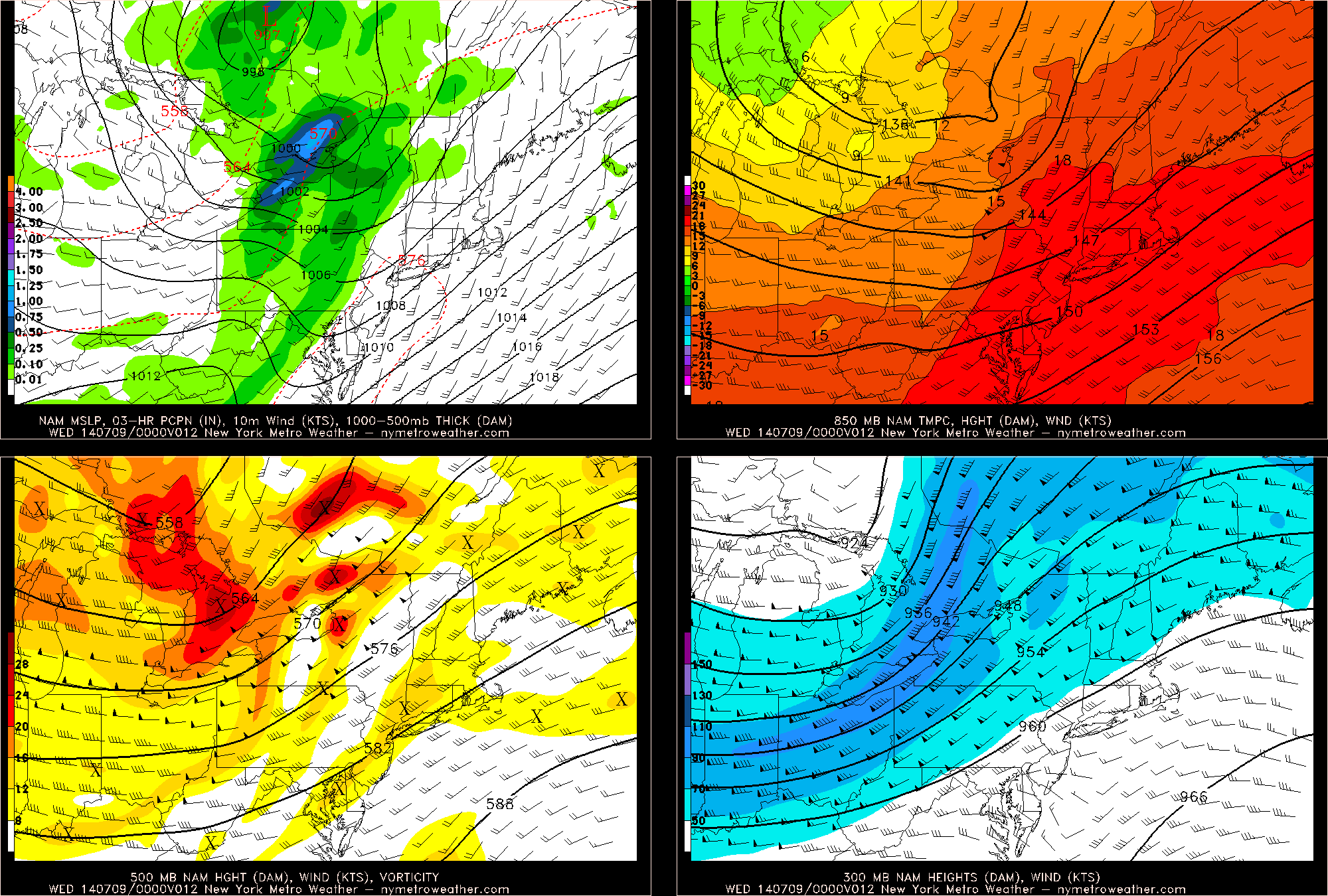
A very interesting meteorological setup for severe weather looks to unfold tonight. A large blocking pattern in the Arctic has forced a large trough to dig into the Midwest, and this will eventually swing through to our area, yielding a potent storm system to our northwest. Although it is often much easier to get thunderstorms during the summer when airmasses are warmer, storm systems are usually stronger during the Autumn, as there is often a larger difference in temperature — or a battleground — for a storm to form. Considering this, plus the fact that in early October the Atlantic Ocean is still quite warm, it becomes much easier for severe weather to be supported near the coast. The strong storm system will serve to bring warm, moist air from the Atlantic Ocean, yet also provide colder temperatures aloft, generating plenty of instability. Additionally, instead of the rising air for showers and storms coming from sunshine heating the ground, we are able to generate forcing for lift from that strong storm system. This gives us the basic foundation for severe weather tonight into Wednesday morning. But this situation remains quite unique.

Arguably the most impressive facet of this potential threat is the strong winds just above the ground. When winds change direction (clockwise) from the ground and up, as well as greatly increase in speed, that is when strong wind shear is created, which supports rotating thunderstorms, capable of producing strong wind gusts and isolated tornadoes. Given that surface winds will be out of the southeast, and winds just above the ground will be in excess of 50 knots out of the southwest, plenty of wind shear is generated. When this is combined with instability, those rotating updrafts can be lifted into thunderstorm clouds, and severe weather can be realized. Without the instability to lift rotating updrafts into thunderstorm clouds, thunderstorms greatly diminish in coverage. Lots of recent model data, however, shows a good combination of potentially rotating updrafts and instability, which piques our interest.

Read more

Strong storms possible with big cold front Thursday

A significant cold front moving through the Central United States will approach the region late on Thursday evening, bringing a wind shift and drop in temperatures both aloft and at the surface. The cold front is associated with a major mid level disturbance, which will shift from the North Central US into Southeastern Canada. As the front shifts through our region, moderate instability and favorable wind fields could support the development of strong/severe thunderstorms.

The Storm Prediction Center has placed parts of the area in a Slight Risk for severe thunderstorms on Thursday afternoon and evening, citing a risk for strong winds. In addition to the winds, unseasonably high precipitable water could support heavy rain and flooding in any storms that shift through the area Thursday evening. But the severe weather threat isn’t as straightforward as it may seem.

Read more

Severe weather, heavy rain likely Monday

As an expansive, powerful upper level low will shift eastward from the Great Lakes toward parts of the Ohio Valley late this weekend into early next week. Immediately, the southerly flow ahead of it — and the nature of the upper level low shifting so far south this time of year — caught forecasters eye for severe weather potential in the Northeast US.  The combination of warm, southerly flow ahead of the approaching upper level low will at least support the potential for heavy rain, while the severe weather setup has become more complicated.

Sunday evening, the first “threat” for thunderstorms will develop over Pennsylvania and Western New York state, where lift for thunderstorm development and instability will support severe storm potential. These storms will move eastward toward parts of our area later tonight, but are expected to weaken over time as they lose support for organization. On Monday, however, things will change — as southerly flow strengthens in our area, shear aloft increases, and lift develops during the afternoon to aid in the development of thunderstorms. Figure 1 shows the approaching upper level system.

Figure 1 - NAM model showing the upper level system shifting toward the area on Monday.

Figure 1 – NAM model showing the upper level system shifting toward the area on Monday.

Read more

Strong, severe storms possible this afternoon west of NYC

Hazy, hot and humid air has settled into the region this afternoon as southerly winds pump in the warmth thanks to mid level ridging. Back to our west-northwest, an energetic disturbance is ejecting northeastward through the Ohio Valley. Increased lift and forcing is helping to force the development of thunderstorms within an unstable environment, leading to the threat of widespread severe weather over Pennsylvania and New York State. The Storm Prediction Center has issued a Moderate Risk for severe weather in those areas through this evening.

Why is this threat developing? 

There are many pieces at play, but the main culprits are most definitely the Western Atlantic Ridge (actually centered near Bermuda at this point) and the incoming energetic trough. The combination of the two is leading to increased instability, strong forcing for thunderstorms, and sufficient wind shear for storm organization. Figure 1 (below) shows a four panel model image from this afternoons 12z NAM model. On the top left, the model is producing precipitation along elongated height falls from the system to our northwest. On the top right, very warm air at 850mb has advanced into the region with temperatures over 18 C. Finally, the bottom two panels show the energetic pattern at 500 and 300 mb.

Figure 1. (NYMetroWeather models)

Figure 1. (NYMetroWeather models)

Read more