Forecast: Gorgeous early-Spring Saturday en route

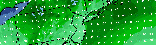
With the absence of a stiff northwest wind and a chance of showers, Saturday’s forecast is already a winner when compared to the past few days. However, the warmer airmass in place will make it even better as temperatures are expected to climb into the upper 50’s on Saturday afternoon and possibly approach 60 degrees in some locations. High pressure will remain in control of the weather, and drier air will likely preclude any showers or widespread clouds. The airmass aloft will only be slightly warmer, but the lack of instability will give the temperatures at the surface a bit more room to rise during the afternoon.

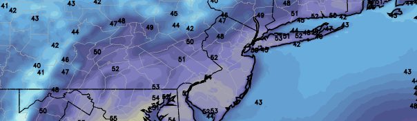
The forecast takes a bit of an unsettled turn by Easter Sunday. After a warm and probably sunny start, clouds will rapidly increase and showers will become likely during the day. Temperatures will remain somewhat warm, but the conditions will be rather raw and the rain could be steady for a period of time as a weak surface low forms just southeast of Long Island on a warm front. After the front pushes through, however, temperatures are expected to warm up by Monday morning. Just barely ahead of a surface cold front, we could see temperatures exceed 60 degrees for a period of time on Monday afternoon. The front will usher in another cooler than normal airmass by the middle of next week.

Saturday: Partly sunny, with highs in the mid to upper 50′s. West winds around 10 miles per hour. A beautiful early spring day.

Saturday Night: Partly cloudy and remaining chilly, with lows in the 30’s. Light west winds.

Sunday: Partly sunny early, with highs in the mid to upper 50′s. Then increasing clouds and showers likely.

Monday: Partly cloudy with a high in the upper 50′s to lower 60′s. A chance of showers in the afternoon and evening, with falling temperatures after sunset.

Forecast: Warmup will preface Easter showers

The NAM model forecasting temperatures warming into the mid and even upper 50's on Easter Sunday, ahead of a disturbance which will bring afternoon clouds and showers.

The NAM model forecasting temperatures warming into the mid and even upper 50’s on Easter Sunday, ahead of a disturbance which will bring afternoon clouds and showers.

A cold upper level low, which meandered over the Northeast United States throughout much of the last five or more days, is finally on the way out late this week. The weakening west-northwesterly flow and warming temperatures aloft will allow for a bit of a warm up at the surface as well. In addition, showers and clouds which plagued the forecast this week are expected to become less frequent. The warmup is expected to continue through the weekend and into Easter Sunday, when temperatures could warm into the upper 50’s.

A weak disturbance along a warm front will make the Easter forecast a bit more complicated, however. Despite the warmup, clouds and showers are expected to develop by afternoon and continue through evening. Temperatures will again fall into the 40’s, as a weak surface low moves offshore. All is not lost, however, as the main front will lag behind into Monday. This will open up the window for an even warmer day on Monday — as temperatures could exceed 60 degrees in front of the front.

Friday: Sunny and a bit warmer, with highs in the low to mid 50’s. West winds around 10 miles per hour. A slight chance of showers in the afternoon.

Friday Night: Mostly clear and cool, with lows in the 30’s. West winds around 10 miles per hour.

Saturday: Partly sunny, with highs in the middle 50’s. West winds around 10 miles per hour.

Sunday: Partly sunny early, with highs in the mid to upper 50’s. Then increasing clouds and showers likely.

Monday: Partly cloudy with a high in the upper 50’s to lower 60’s. A chance of showers in the afternoon and evening.

Forecast: Warming temperatures, in and out of sun

NAM model showing high temperatures in the lower to middle 50's on Friday, a welcomed sight after weeks of below normal temperatures and snow in March. Temperatures will warm into the mid/upper 50's before a chance of showers on Easter afternoon.

NAM model showing high temperatures in the lower to middle 50’s on Friday (colder inland), a welcomed sight after weeks of below normal temperatures and snow in March. 

Colder than normal weather has dominated a great majority of March, with a few chances of snowfall and even one coming after the end of the calendar Winter. However, temperatures have warmed slightly over the past few days — and it feels extra welcome given the below normal weeks behind us. The past few days have featured morning and afternoon sun, but an upper level low aloft has allowed for instability to develop during the afternoon bringing the chances of clouds and showers. Many areas experienced graupel and snow pellets, owing to the cold pool aloft (see the post below) on Monday and Tuesday. Thursday featured much of the same, with morning sun giving way to afternoon clouds as one final disturbance aloft moves through from the north. Showers should be more limited, but clouds will be present for much of the afternoon especially on the shore and east of the city on Long Island.

The forecast takes a more pleasant turn for Friday and Saturday, with temperatures warming up into the middle 50’s for highs and less clouds during the afternoon hours. Easter will feature the potential for showers in the afternoon and evening, despite a pleasant start to the day. Warm temperatures (possibly upper 50’s for highs) during the early afternoon will gave way to the aforementioned showers, which will come ahead of another disturbance which is expected to approach the area by early next week. We’ll keep an eye on the hour-by-hour Easter forecast as we move forward. For now, check out your quick forecast below.

Rest of Today (Thursday): Mostly cloudy with highs in the low 50’s. A slight chance of showers. Northwest wind around 10 miles per hour.

Tonight: Mostly cloudy, becoming partly cloudy, with a low in the mid 30’s. Northwest winds around 10 miles per hour.

Friday: Partly sunny, with highs in the mid 50’s. Northwest wind around 10 miles per hour.

Saturday: Mostly sunny, with a high in the mid 50’s. Feeling warmer with less clouds.

Sunday: Sun early, and warmer with highs in the mid to upper 50’s. Increasing clouds by afternoon with showers becoming likely.

Fair weather on the way in wake of nor’easter

Water vapor satellite imagery early Tuesday morning, showing the strong coastal system moving away to the Northeast and calmer, drier weather approaching.

Water vapor satellite imagery early Tuesday morning, showing the strong coastal system moving away to the Northeast and calmer, drier weather approaching.

A late season winter storm impacted the area on Monday, with less flair than originally expected. Warm ground temperatures (and warm air temperatures during the day) combined with light precipitation rates to keep it mainly a non accumulating snow event in Northern NJ and New York City. Dry air won the battle over precipitation farther north over Connecticut and Southeast New York. Farther south, over Central and Southern NJ, a few inches of snow were observed through Monday evening. The brunt of the storm (as far as heavy banding and the low pressure center), however, remained barely offshore. In the end, the storm system will likely be remembered as a “near miss for the area”. As we move forward into the week, a moderating trend in temperatures and dry weather are in the forecast — and it should at least begin to feel a bit more like Spring.

Cool air will hang on initially, with some clouds and a slight chance of showers on Tuesday. High temperatures in the upper 40’s, approaching 50, are expected. Cool nights will still be present with lows in the 20’s and 30’s — so don’t put away the coats just yet. Additionally, the cold air is still present to our north (owing to the big blocking and historically negative AO we experienced last week), so that could take a while to shake. By late this week into the weekend, high temperatures are expected to reach into the 50’s. I think it’s safe to say we are all looking forward to it.

Tuesday: Partly sunny with a high in the mid to upper 40′s. Northwest winds around 10 miles per hour. A slight chance of showers in the afternoon.

Tuesday Night: Mostly clear and cool with lows in the upper 20′s to middle 30′s. Northwest winds 1o to 15 miles per hour.

Wednesday: Mostly sunny with a high in the mid to upper 40′s. West winds around 10 miles per hour.

Thursday: Mostly sunny and feeling warmer with a high in the mid to upper 40′s to near 50. Overnight low in the mid 30′s.