Storm to bring myriad of threats through Thursday

NAM Model showing a significant storm system impacting the area Wednesday Night into Thursday, with snow inland, a wintry mix across some suburbs, and rain/wind near the coast.

NAM Model showing a significant storm system impacting the area Wednesday Night into Thursday, with snow inland, a wintry mix across some suburbs, and rain/wind near the coast.

A powerful storm system which brought torrential rains, heavy snow, and severe weather (including several strong tornadoes) to the Central United States is on the move this evening, heading northeastward towards the Mississippi Valley and eventually the Northeast States. The storm will eventually re-develop to a position near New York City by later Wednesday Night, bringing with it the potential for significant precipitation. Cold air entrenched in the low levels of the atmosphere will initially allow for snow across the interior. However, a rapid change is expected as warm air advection begins at all levels of the atmosphere — mid levels first, with precipitation changing to rain at the coast very quickly. The wintry precipitation should hold for several hours across inland locations, but snow could mix with sleet/ice pellets. By the time the storm is over, all areas will have changed to rain — and the threat for strong winds will exist near the coast as the heaviest precipitation moves through late Wednesday Night into early Thursday Morning. Below, we’ve detailed the potential threats and the timing for each one.

Storm Total Snow Forecast | December 25th, 2012
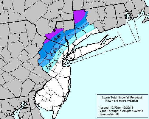
Snow: Many areas could begin with some snow flakes, but the storm will certainly be characterized by a changeover to rain. This change will occur gradually, and will be faster to occur near the shore and in the city and slower to occur inland especially in the higher elevations. For a few hours, the immediate suburbs could see a flip from snow to sleet before the changeover to rain. As is the case with amny systems like this one, the mid level warm air advection will win out before the low levels cool. So precipitation will likely flip to sleet across many areas before turning to all rain. Inland, across the high elevations of Northwest NJ, Southeast NY and Connecticut, a more prolonged period of snow and sleet could lead to light to moderate snowfall accumulations. Precipitation is eventually expected to flip to all rain throughout the areas, becoming heavy at times. To the left, we’ve attached our storm total snowfall forecast which is valid from this evening through Thursday Night.

Rain: The potential exists for periods of heavy rain, especially near the coast during the height of the storm. Forecast models are indicating the potential for over 2 inches of precipitation throughout much of the area by the time all is said and done. Some localized flooding cannot be ruled out, especially as these totals could come in a relatively brief period of time.

Wind: Forecast guidance also indicates the potential for strong winds and dangerous wind gusts, especially near the coast. As the low pressure passes close to the forecast area Wednesday Night into Thursday, a very strong low level jet will pass nearby bringing with it strong southeast winds. The winds in the low levels of the atmosphere, just above the surface, will be especially strong thanks to this low level jet. If lapse rates can steepen and these winds can mix down, the potential exists for gusts over 60 miles per hour. The strongest winds appear likely near the New Jersey, New York, and Connecticut coasts…especially the Jersey Shore, Long Island, and New York Harbor.

We encourage you to stay tuned for the latest updates on this storm system as it approaches the area. Our Facebook and Twitter accounts will have the latest up to the minute information as well.


Light wintry mix expected Christmas Eve and morning

NAM model forecasting an inch or so of snow Christmas Eve into Christmas morning across interior locations of New Jersey, New York, and Connecticut.

NAM model forecasting an inch or so of snow Christmas Eve into Christmas morning across interior locations of New Jersey, New York, and Connecticut.

A weak disturbance in the mid levels of the atmosphere is approaching the area this afternoon and evening, and touching off light to moderate precipitation across the Mid-Atlantic states. The weak surface low will continue to move north and east, to a position off the coast of Long Island tonight. Light snow will overspread the region between 7 and 9 pm, likely beginning as snow (albeit briefly) in most areas. Most locations near the coast and city should see a transition to rain, while areas farther inland could see a prolonged period of snow or sleet. Regardless, flakes will be flying in the NYC area this Christmas Eve, and will continue into the early morning hours of Christmas Morning.

Total snowfall accumulations are expected to be light, with the greatest amounts of an inch or so across the interior areas of Northwest New Jersey, Southeast New York, and non-coastal Connecticut. A trace or dusting is possible in the city and along the coast, but generally no accumulations are expected there. Clearing is expected by later Christmas morning, and the sun may even briefly return before high clouds start to build in, in advance of the next system.

More on that system tomorrow — have a wonderful and blessed Christmas Eve!

Strong cold front could bring heavy rain, high wind early Friday

NAM Model showing a line of showers and embedded heavy rain crossing the area early Friday along a strong cold front.

NAM Model showing a line of showers and embedded heavy rain crossing the area early Friday along a strong cold front.

A very strong cold front is expected to pass through the area this evening into early Friday morning, and could bring heavy rain and strong gusty winds with it. In addition, a sharp drop in temperatures and shift in wind direction will occur behind it as a briefly warmer and more humid airmass is washed away to the east. Forecast models indicate the potential for a low-topped line of heavy rain and possibly even an embedded storm or two. A very strong low level jet (winds in the lower levels in the atmosphere, but above the surface) will pass over the region, juxtaposed with this area of potential heavy rain/storms. Despite an inversion, if any heavy rain/storms can mix down these winds effectively, the potential for strong gusts of wind exists. The temperature drop should be dramatic as well — with forecast models indicating a period of time where temperatures are in the 50’s in NYC (ahead of the front) and in the 20’s over Central PA (behind the front). After the front passes on Friday morning, strong and blustery west winds should continue throughout the day despite clearing conditions. By Friday afternoon, some snow showers are possible throughout the area as the strong winds both at the surface and aloft advect in a new, cold airmass.

Rest of Today: Mostly cloudy, temperatures topping out in the mid 40’s. Southeast winds increasing by evening.

Tonight into Friday Morning: Showers likely, with a period of very heavy rain after midnight into the early morning hours. Temperatures should rise overnight into the 50’s by the early AM hours. Then, heavy rain and strong gusty winds are possible with the passage of the front. Overnight low near 44.

Friday: Showers early, then clearing somewhat by late morning. Clouds should return by afternoon, with cool temperatures and strong westerly winds. A chance of snow showers by afternoon. West winds gusting over 20 mph.


A Brief Overview of the Weather for the Next Few Days

After the storm we had on Tuesday moved out of the area, we saw sunny skies and chilly weather on Wednesday as cold air filtered into the area behind the storm system. Today and Friday will have quite similar conditions, as a zonal flow across the county will not allow for any major dips in the jet stream to support strong storms.

A strong high pressure system has moved into the eastern half of the country, just to our south. This will provide our area with sunny skies and westerly winds for today, with temperatures in the mid 40s for most of the area. Tonight/Friday morning’s low temperature should be in the upper 20s in most of the region, with low 30s in more urban locales.

The 00z GFS forecast at 500mb, valid for Friday at 2pm. The pattern across the country is zonal, leading to no major storm systems for our area.

For Friday’s forecast, I’m going to show a couple of visuals. At 500mb, you can see the zonal flow across most of the country, which is helping to keep things quiet, for the most part. There is a ridge of warmth in the Central Plains which is heading eastward, which will warm us up a tad for Saturday and especially for Sunday and the days after that. Also, you can see a very weak area of vorticity in Michigan associated with a small shortwave trough that is heading eastward. This, combined with the fact that the warm air to the south and west will be overrunning the chillier airmass to the north and east will help to provide clouds and showers to the region for Saturday. The rain, if any, though, should be quite light and not cause too many problems.

Read more