What the stratosphere and tropical Pacific can tell us about December

For the better part of the last three weeks, our forecasters have been discussing and monitoring the potential for a pattern change throughout the hemisphere. Medium range model guidance has often been gung-ho with the pattern changing within 7 days. As is often the case, forecast models were too quick to change the pattern. Much of this has to do with poor forecasting of the stratosphere and tropical Pacific ocean. Not coincidentally, these two features can give us clues as to where the pattern is heading in the weeks ahead.

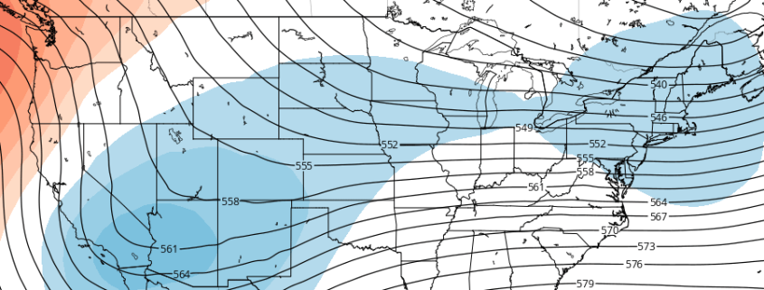
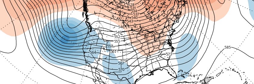
As it stands this afternoon, model guidance and ensembles are in good agreement that a -NAO (North Atlantic Oscillation) pattern will develop over the next two weeks. This pattern is often defined by large ridges or higher than normal heights in the atmosphere over Greenland and the North Atlantic Ocean. -NAO patterns can allow cold air to be displaced farther south into the Northern 1/3 of the United States, particularly the Central and Eastern United States.

Read more

Premium: Late month pattern change likely to be gradual

As discussed in the winter forecast, the stratospheric polar vortex has been weakened since late October. A wave-breaking event, mainly induced by a large ridge in the Kara Sea, has resulted in 100mb heat fluxes remaining above average. We still believe the polar vortex is likely to be weaker and more disturbed going into this winter, especially compared to the past several years.  However, some resistance from the polar vortex and tropical forcing influences will likely result in more gradual step down into pattern changes over next several weeks.

While westerly zonal winds have decreased to below average levels, a wind reversal or easterly winds aren’t being forecasted, particularly around 10mb and 60N. EPV at 10hpa also appears to shift from being poleward to more equatorward by the third week of November. Despite being severely disrupted; these winds allow for the polar vortex to remain quite large and profound over the high-latitudes. This will likely result in more neutral modality with the AO/NAO over next few weeks.

Read more

Hurricane Matthew’s Potential Impacts on the Caribbean and United States

Matthew unexpectedly underwent rapid intensification to category 5 hurricane on Friday. This is despite between 20-30kts southwesterly shear over the eye. Today, Matthew has slightly weakened down to category 4  hurricane. But still remains a very powerful and dangerous hurricane.  Matthew has been moving very slowly west-southwestward over the Central Caribbean. But is expected to make gradual turn northward later tonight and Sunday. This will take the eye somewhere between Jamaica, Eastern Cuba and Haiti Bahamas by Monday. Then somewhere over the Bahamas by Tuesday and Wednesday. So will Matthew turn towards the United States or will go out to sea? Well alot depends how it interacts with incoming trough and how strong the ridge is over the Western Atlantic.

Read more

Premium Weekly Outlook: A cut-off low brings unsettled weather and rainfall

So far this month, while there have been cool shots, we’ve seen warmer than normal temperatures dominate for a longer period. It has also been quite dry. But more seasonable temperatures and unsettled weather is looking likely for this weekly period overall. So much-needed rainfall may also be on the way, especially for Long Island which is currently under a severe drought.

Today has gotten of to a chilly start with temperatures in the 40s over most of the region. Some interior locations and the Pine Barrens dropped down into the middle to upper 30s with some pockets of frost. Sunshine will dominate much of the day and it will be pleasant Autumn afternoon overall. But some clouds will begin increasing later this afternoon, as a frontal boundary associated with a closed upper-level over Great Lakes begins approaching the region. Temperatures will still reach the upper 60s to lower 70s across most of the region.

Read more