The meteorology behind Hurricane Sandy’s very low pressure

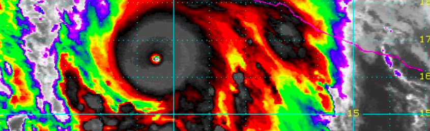
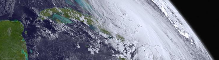
Nearly three years since Hurricane Sandy, many of her visual scars have faded. The memories of the storm, for many, have not. Meteorologically, Sandy remains just as incredible now as she was then — an unbelievable display of atmospheric power. One of the most fascinating aspects of Sandy was how strong she was, despite entering cooler waters. The meteorology behind her pressure is powerful and intricate, still, three years later.

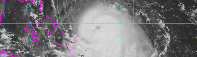
Hurricanes have a strong warm core at the surface, weaken with height, and are barotropic — meaning there are no temperature or density gradients in their environment. This means that they are symmetric — their warm core is entirely surrounded by slightly cooler, but still abundantly warm air. The combination leads to hurricanes being vertically stacked (not tilted with height). Thus, hurricanes need warm water and weak upper-level winds in order to strengthen. Strong upper-level winds can choke a hurricane’s outflow channel, and advect in new airmasses of different temperatures — providing temperature gradients that hinder their development.

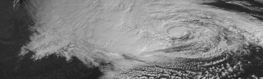
In further south latitudes, waters tend to be warmer, and the jet stream tends to be weak. As you head further north, however, the water becomes colder and the jet stream strengthens, leading to stronger upper-level winds. This helps to weaken a hurricane’s warm core at the surface, and tilt its vertically stacked structure, weakening the storm. However, as Sandy headed north, she was able to maintain category one hurricane strength with abnormally low pressures and eventually went on to cause widespread devastation. Why?

Read more

Patricia becomes strongest hurricane ever in satellite era

Hurricane Patricia, located in the Eastern Pacific and in the midst of a catastrophic turn toward Mexico, strengthened this morning, becoming the strongest hurricane on record in the Western Hemisphere. With maximum sustained winds of 200 miles per hour, gusting to 245 miles per hour, and minimum central pressure of 880mb, Patricia is also the strongest hurricane since the satellite era began.

The incredible hurricane has strengthened dramatically — at a near record breaking pace — over the past 24 to 48 hours. The hurricanes maximum sustained winds increased 100 knots within a 24 hour period from 4am CDT on Thursday to 4am CDT on Friday. This morning, Patricia strengthened additionally, becoming the strongest Hurricane ever measured within the National Hurricane Center’s area of responsibility.

Read more

Joaquin strengthens, models shift dramatically seaward with track

As it moved through the very warm ocean waters near the Bahamas on Thursday, Hurricane Joaquin strengthened further, reaching Category 4 status on Thursday afternoon. Maximum sustained winds reached 130 miles per hour. The National Hurricane Center suggests additional strengthening is possible, with maximum sustained winds approaching 140 miles per hour.

Computer models have continued their immense struggles with the track and intensity of Joaquin. A storm which was modeled by only a select few to become a major hurricane just days ago, has strengthened far beyond additional expectations. One of the major reasons for this is a farther south track — into warmer waters — which also was not anticipated by modeling until 36-48 hours ago when the ECMWF was the first to suggest a southward jog.

Read more

Joaquin likely to impact US East Coast, local impacts uncertain

Hurricane Joaquin strengthened this morning, with maximum sustained winds of 80 miles per hour, in the Caribbean. The hurricane is expected to strengthen further over the next few days as it meanders in the Southwest Atlantic. Warm waters and minimal shear will continue to support storm organization. Thereafter, Joaquin is expected to make a turn northward, moving into the Southwest Atlantic Ocean. As it does so, an energetic disturbance over the Southeast States will race toward the storm. As the two phase, Joaquin is expected to accelerate and make a rapid turn west toward the Mid-Atlantic coast.

Exactly where the storm tracks, and how strong it is, remains highly uncertain at the present time. Forecast models are struggling with intricate details of the atmospheric setup. Unsurprisingly, small changes in the atmospheric interactions will have big changes on the eventual outcome and effects along the East Coast. The potential envelope of solutions remains extremely large — and so this post will attempt to explain the atmospheric setup, potential scenarios, and possible hazards in our area

Read more