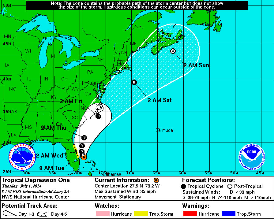
A developing tropical system is expected to shift northwestward toward the Southeast US coast over the next 24 hours, strengthening from a Tropical Depression into a Tropical Storm at some point during this week. This, almost all forecast models agree upon. What happens thereafter is another story. From Thursday morning forward, there is a considerable amount of spread amongst usually reliable guidance, as the tropical system will shift northeastward along the Mid-Atlantic states of the East Coast. Eventually, an incoming trough and shortwave will kick the tropical system to the north and east, but the timing of this depends highly on the positioning of said feature during the latter half of this week.
This means that our fourth of July forecast is up in the air — and at risk of being spoiled by tropical rains. Adding to the issue is the potential for rain along the front, even if the Tropical Storm is hundreds of miles to our east. We can thank extra lift from the incoming troughing system for this, and many models are picking up on the potential for heavy rain along this band of lift from Thursday Night into Friday. After that, the track of the exact low pressure center would obviously have more significant impacts on our weather.
https://www.nymetroweather.com/wp-content/uploads/2024/02/Empire-2000-x-300-px-2.png00John Homenukhttps://www.nymetroweather.com/wp-content/uploads/2024/02/Empire-2000-x-300-px-2.pngJohn Homenuk2014-07-01 08:13:392014-07-01 08:13:39TD1 expected to skirt East Coast on Independence Day
One year ago today, Hurricane Sandy made landfall on the New Jersey Coast. The storm, although well predicted several days in advance, caused billions of dollars in damage as well as significant loss of life and property. In addition to our Hurricane Sandy Anniversary Archive, our forecasters have chosen ten of the most shocking images that still remain incredible a year later — showing the size, strength and impact of Sandy in our area.
One of the most fascinating aspects of Sandy was how strong she was, despite entering cooler waters. Hurricanes have a strong warm core at the surface, weaken with height, and are barotropic — meaning there are no temperature or density gradients in their environment. This means that they are symmetric — their warm core is entirely surrounded by slightly cooler, but still abundantly warm air. The combination leads to them being vertically stacked (not tilted with height). Thus, hurricanes need warm water and weak upper-level winds in order to strengthen. Strong upper-level winds can choke a hurricane’s outflow channel, and advect new airmasses of different temperatures — providing temperature gradients that hinder their development. In further south latitudes, waters tend to be warmer, and the jet stream tends to be weak. As you head further north, however, the water becomes colder and the jet stream strengthens, leading to stronger upper-level winds. This helps to weaken a hurricane’s warm core at the surface, and tilt its vertically stacked structure, weakening the storm. However, as Sandy headed north, she was able to maintain category one hurricane strength with abnormally low pressures and eventually went on to cause widespread devastation. Why?
Sandy was able to maintain strength and deepen as she became a hybrid of a tropical low and an extratropical low. Strong extratropical lows, such as nor’easters, have cold cores at the surface. Instead of being vertically stacked, they tilted towards cold air with height. This means that they are baroclinic; thermal and density gradients exist in their environment, including frontal systems. More specifically, they are asymmetric — with cold air on the west side of the circulation, and warm air on the east side (by definition, a temperature gradient). Sandy was a hybrid in that she had a warm core of strong winds, but was also asymmetrical, meaning her strength was aided by strong upper-level winds and thermal gradients, instead of being hindered by them.
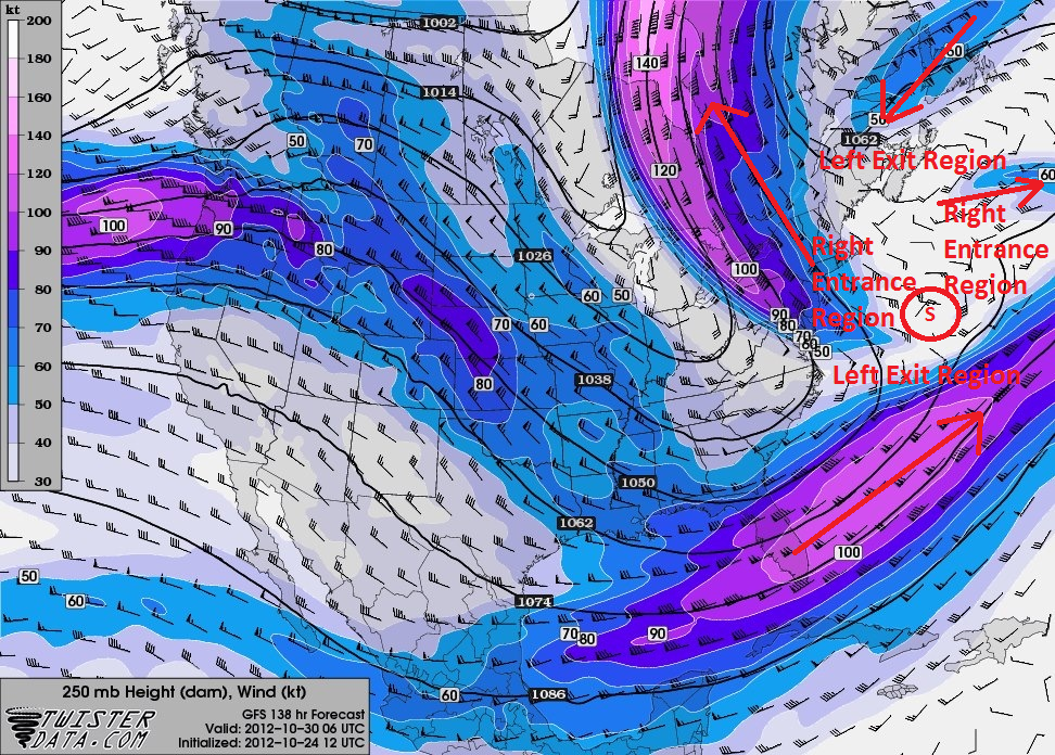
The large trough that phased with and turned Sandy to the west had an abundant source of cold air and strong upper-level winds. There were actually reports of 2-3 feet of snow in West Virginia! That cold air was able to clash with the warmer, tropical air, creating a steep thermal gradient, helping Sandy’s pressures to deepen, despite heading towards colder waters. Additionally, there were several sources of strong upper-level winds that were all co-located in a perfectposition for serious strengthening. When forecasters saw these localized areas of strong upper-level winds (also called jet streaks), it was pretty evident that the model solutions which took Sandy to pressures around 940mb at landfall were not off the wall, and were very much possible.
A GFS forecast showed that Sandy was located in the presence of four different jet steaks — each one favoring a strengthening storm. Sandy is denoted with the circle and the “S” inside. The jet streak regions are drawn and labeled as well.
Warmer temperatures have been the trend over the past few days — and the pleasant streak of weather we have experienced over the last few weeks now looks to take a brief respite as we head into the weekend and the early part of next week. Increasing humidity today, coupled with a nearby boundary and mid-level atmospheric disturbance will mean increasing clouds and the chance for showers and an isolated thunderstorm. Showers and storms haven’t been around in a while — in fact, almost two weeks (more in some spots). Today will bring isolated to scattered showers and storms throughout the area from west to east, but the main story will be the humid feeling air and presence of more clouds than sun.
US Water Vapor satellite imagery, frontal positions, and SPC severe weather outlook from the morning of October 4 2013. A disorganized T.S Karen is seen in the Gulf of Mexico.
The unsettled weather will continue through later tonight, but only scattered showers are expected this weekend. The main story will then be the remnants of Tropical Storm Karen, and whether they track close enough to our area up the East Coast early next week to provide tropical rains. Forecast models have diverged in solutions, with some showing tropical rains and some wind while others now shunt the remnants of the system eastward out to sea.
Hi friends! Our website uses cookies to provide an optimal browsing experience for you. New "Cookie Consent" laws mandate us to inform you of this. As long as you're cool with it, just hit OK. You'll only see this message once.
We may request cookies to be set on your device. We use cookies to let us know when you visit our websites, how you interact with us, to enrich your user experience, and to customize your relationship with our website.
Click on the different category headings to find out more. You can also change some of your preferences. Note that blocking some types of cookies may impact your experience on our websites and the services we are able to offer.
Essential Website Cookies
These cookies are strictly necessary to provide you with services available through our website and to use some of its features.
Because these cookies are strictly necessary to deliver the website, refusing them will have impact how our site functions. You always can block or delete cookies by changing your browser settings and force blocking all cookies on this website. But this will always prompt you to accept/refuse cookies when revisiting our site.
We fully respect if you want to refuse cookies but to avoid asking you again and again kindly allow us to store a cookie for that. You are free to opt out any time or opt in for other cookies to get a better experience. If you refuse cookies we will remove all set cookies in our domain.
We provide you with a list of stored cookies on your computer in our domain so you can check what we stored. Due to security reasons we are not able to show or modify cookies from other domains. You can check these in your browser security settings.
Other external services
We also use different external services like Google Webfonts, Google Maps, and external Video providers. Since these providers may collect personal data like your IP address we allow you to block them here. Please be aware that this might heavily reduce the functionality and appearance of our site. Changes will take effect once you reload the page.
-2")