PM Update: Pleasant evening, clouds on the increase

A gorgeous Wednesday is wrapping up throughout the NYC Area with temperatures in the middle 70’s and light southerly winds — a true gem of a day which featured low humidity and enjoyable conditions for early June. The pleasant weather is on the way out by later this week, however, with clouds increasing on Thursday and chances for rain increasing as well. Periods of steady rain are possible with tropical moisture surging into the area this weekend.

Rest of Tonight: Pleasant evening, with temperatures in the middle 70’s, falling into the upper 50’s. A bit cooler, as usual, near the shore and in the suburbs. Clouds could increase by later in the overnight period towards early morning.

Thursday: Partly to mostly cloudy in the morning with some breaks in the clouds during the afternoon. The showers should hold off until late — so it appears that Thursday could be salvaged. Highs in the lower 70’s throughout the area with a southeast breeze. It will be a little cooler near the shore.

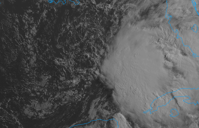
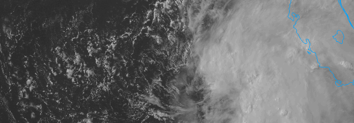
Tropical Storm Andrea forms, remnants likely to impact the area: NWS Recon planes found Tropical Storm force winds and a closed center in a tropical entity in the Gulf of Mexico this evening — and will begin issuing advisories on Tropical Storm Andrea tonight. More importantly for our area, the tropical system will be scooped up by a progressive trough over the Ohio Valley late this week.

Forecast models are in good agreement on the fact that a surface low will eventually make its way up the east coast — with periods of heavy rain likely near and to the west of the surface low. The exact track of the surface low remains somewhat uncertain, and will determine where the heaviest rain falls. Regardless, it looks like a cloudy and rainy forecast from Thursday Night through Saturday.

Cicadas peaking in the suburbs: Just three weeks after they first appeared, the 17 year Brood II Magiciadas are causing a dramatic ruckus in the suburbs of NYC including New Jersey, Southeast NY and Connecticut. Many areas in Northeast NJ (specifically Union. Morris and Essex counties) have reported millions per square mile. The sound of the cicadas mating call is one of the loudest sounds in nature.

The cicadas will make a ton of noise over the next few days — but after mating will begin to die off as quickly as they came. After the females lay eggs in the branches, the cicadas will die off completely. The nymphs will hatch from the branches later this summer, and drop to the ground. Soon after they will bury underground, and won’t be seen again for another 17 years.

GOES 13 will return tomorrow: The “broken” weather satellite GOES-13 is expected to return to service on June 6th, 2013. The satellite has been out of service since May 22nd, 2013 after suffering from an unknown disturbance. Our friends at Climate Central have all the details.


Tropical moisture could spoil weekend

The pleasant, dry and less humid weather which has settled into the area during the middle of this week, however enjoyable, looks to be short lived. Forecast models have been consistent in taking a weak (possibly tropical) system with an impressive amount of low level moisture, and tracking it from the Gulf of Mexico up along the East Coast. With the weak shortwave being scooped up by a progressive trough over the Ohio Valley, a surface low is forecast to develop and move up the East Coast beginning Thursday and continuing into early Saturday.

The system in the Gulf of Mexico, which is forecast to develop into a tropical entity by some models, is struggling amidst strong upper level winds. But it still may develop into a weak system before ejecting north and east and being absorbed into the mid level flow. The National Hurricane Center suggests the system has a 50% chance of developing into a tropical system.

Visible satellite imagery of a tropical disturbance in the Gulf of Mexico on the morning of June 5th, 2013.

Visible satellite imagery of a tropical disturbance in the Gulf of Mexico on the morning of June 5th, 2013.

The result, in terms of sensible weather for our area, will be clouds and showers beginning late Thursday and continuing through at least the first part of the weekend. The exact track of the surface low and interactions aloft will determine where the heaviest rain falls, but needless to say periods of rain are likely with the potential for some thunderstorms as well. Late Thursday into early Saturday in particular look to feature the most unsettled weather. Things look to clear out a bit during the day on Saturday, so Sunday could be salvaged if the timing holds up.

Be sure to follow our social media accounts on both Facebook and Twitter for up to the minute information and interaction.

Dangerous Hurricane Sandy set to slam into the area

Hurricane Sandy in the Western Atlantic on the afternoon of Sunday October 28th, 2012. Notice the front to her west, which she will phase with tomorrow.

A storm of record breaking size will take an unprecedented track from the Western Atlantic Ocean back to the US East Coast, likely making landfall on the New Jersey Shore late Monday Night into early Tuesday Morning. None of us have seen a storm similar to the one we are set to experience over the next few days. While our objective is to not sound like alarmists, our job is also to inform the public of the potential hazards. In this case, the potential hazards are more dangerous than usual. Over the next few days, hazards will include hurricane force winds, record setting storm surge, and widespread flooding rains. Below, we highlight today’s new developments, bring you our first event timeline and hazard overview. If you haven’t yet, check out our last article for a detailed look at why the threat is developing.

Brief: What are the major developments/changes over the last 12-24 hours? Not many in terms of the storms expectations, but lots of news from government officials. The National Hurricane Center is still expecting the storm to make landfall along the Central NJ Coast. Storm surge estimates have been updated to 6-11 feet. For perspective, general storm surge from Hurricane Irene was 4 feet. The NYC Mayors Office announced all Public Schools are closed on Monday, and the MTA announced that all public transportation will stop running at 7pm Sunday. In addition, mandatory evacuations are in effect for Zone A (low lying areas) of NYC. Mandatory evacuations continue for barrier islands of both New York and New Jersey with voluntary evacuations along most of the NJ/NY shores.

What are the main threats with Sandy?

  • Storm Surge: Sandy is the largest tropical cyclone in the Atlantic Ocean (yes, in history). She is piling up a ton of water and as she phases with the upper level trough to our west and recurves towards us, it will come directly at the east coast. The NWS is forecasting a storm surge of over 6 feet and a maximum of 11 feet. If you live a storm surge prone area, evacuate.
  • Flooding: Heavy rain and high winds plus storm surge will cause significant amounts of coastal flooding. If you live on a barrier island, near the ocean, or near a body of water, we recommend evacuating as well. Flooding is also likely inland from heavy rain. If you live in an inland flood prone area, move to a higher ground or prepare for the flooding.
  • High Winds: Sandy will merge with another upper level storm and become a very powerful low pressure area. The jet streams will feature some very strong wind fields just above and at the surface. Tropical storm force winds are likely throughout the area, and hurricane force wind gusts are also possible. This is especially true near the coasts. Prepare for the potential for widespread wind damage.

Have you been able to narrow down an expected timeline of events? Yes. Our team of meteorologists has worked out the following spread of expected timing of hazards to help you remain prepared.

Sunday Night

  • Showers becoming widespread throughout most of the are from southeast to northwest. Winds will begin to increase. This is your last chance for final preparations. It’s better to be safe than sorry — so be prepared.
  • Winds will increase but there will still be periods of calm winds…with gusts increasing in intensity and frequency by the overnight period.

Monday

  • Morning: Things will rapidly go downhill during the day on Monday. In the morning, expect a moderate breeze at almost all times with gusts higher than that. This will be especially true along the shore. Rain increasing in intensity and becoming widespread. The first signs of storm surge and coastal flooding along the shores and storm surge prone areas.
  • Afternoon: Very heavy rain throughout most of the area. Winds rapidly becoming sustained near Tropical Storm Force. Hurricane force wind gusts along the shore and possible inland as well. Storm surge and high waves begins to pound the NJ Shore and Long Island Sound.
  • Evening: The worst of the storm system. The surface low will be swinging towards the NJ Shore and will eventually make landfall. As it does, winds will abruptly shift southeast in almost all of the area’s coastal locations. The storm surge will be at its worst. Very heavy rain, widespread flooding, tropical storm force sustained winds with gust over hurricane force are likely throughout the area. Do not travel Monday Night unless it is absolutely necessary. Leave the roads open for emergency services and do not travel simply for your own safety.

Tuesday

  • Morning: The worst of the storm continues for a few hours into Tuesday morning (could end slightly earlier depending on storm timing). Southeast gale force winds will continue to hammer the New Jersey shore, and will bring significant amounts of storm surge into NY Harbor and the South facing shores of Long Island and the LI Sound. Winds continuing with Tropical Storm force sustained and Hurricane Force gusts.
  • Afternoon: The worst of the winds will begin to die down with strong gusts still possible and sustained winds still over 25 miles per hour along the shores. Showers will remain in the forecast throughout the day despite a decrease in moisture.
  • Evening: The storm begins weakening over land and the atmospheric setup becomes less favorable for strong winds and heavy precipitation. Isolated showers will still continue, however, through most of the area.

At this point, what can I do to be best prepared? Today is the last day to make preparations. If you haven’t yet, for whatever reason, you should do so now. This is a potentially life-threatening storm system. No, this does not mean that your life will be at stake the entire event as you cower in a corner. But don’t take the chance of not being properly prepared. Here are the recommended pre-storm preparations..

If you live on the beach, near the shore, or on a barrier island and are not under a mandatory evacuation:

  • Board up windows
  • Secure boats and docks
  • Remove outdoor decorations or loose objects
  • Clear gutters and drains of leaves and debris
  • Have flashlights, batteries, and essentials available.
  • If possible, have a backup power source available.
  • Charge your cell phone and fill up your car with gas prior to the storm.
  • Have an NOAA weather radio readily available.

If you live inland, in a city or suburb and are not under a mandatory evacuation:

  • Bring in all loose objects outdoors that may fly away
  • Clear gutters and drains of leaves and debris
  • Charge your cell phone and fill up your car with gas prior to the storm.
  • If possible, have a backup power source available.
  • Have flashlights, batteries, and essentials available.
  • Trim loose branches from trees.
  • Have an NOAA weather radio readily available.

You say to prepare for the worst. What if the worst doesn’t happen? Then its better that you were prepared anyway. Storms like this will always end up with us getting angry emails about how some people’s exact location didn’t get severe damage. And ultimately, that’s what is difficult about the weather. Conditions can vary so dramatically — so in this case, for instance, someone is going to see significant flooding and 80mph gusts and somebody isn’t. But the point of the entire thing, this time, is that the hazardous conditions will be much more widespread than usual. So we urge you to prepare, regardless of whether or not you end up seeing severe weather, lose power, or have damage to your home.

Bottom Line: A significant, high impact storm system is set to impact the entire area. Conditions will differ depend on your exact location, but we urge you to prepare for the worst. This is a serious storm system, do not take it lightly. Whether or not you see damage or severe weather, you glad that you were prepared..we can guarantee you that. We remind you to stay with us for future updates on both our Facebook and Twitter accounts. Also, if you have storm reports, submit them to us via email or social media. We need them more than ever during Hurricane Sandy. Stay safe.

Hurricane Sandy to bring widespread impacts to our area

European model showing Hurricane Sandy near landfall on the New Jersey coast this coming Tuesday morning. The purple area indicates hurricane force sustained winds.

Over the last 24 hours, forecast models have come into much better agreement on the eventual track of Hurricane Sandy. Now that she is near the latitude of the Southeast states, there is much less discrepancy amongst forecast models, although there still remains a relatively large spread of solutions for the time frame we are in. Models have honed in on a potential landfall from the Northern tip of the NJ shore (Sandy Hook) to the Delaware beaches or far Southern New Jersey. There are still some outlier models on either side. Regardless of the track, Hurricane Sandy is expected to be a historically strong storm in the Northeast US and will bring a myriad of threats to the NYC and NJ areas. Expect heavy rain, strong wind, dangerous storm surge and wave heights, and the potential for widespread power outages. We detail the threat below in advance of the system.

What’s happening with Sandy now? Sandy is a Category 1 Hurricane off the Southeast Coast this afternoon. Although a Category 1 Hurricane usually doesn’t sound too menacing, sustained winds over 75 miles per hour can cause damage. In addition, the storm is expected to strengthen over the next day or so as she phases with an upper level trough over the Eastern United States. A phasing process and favorable jet stream alignment will set the stage for rapid deepening of Sandy’s pressure — and although the winds won’t match up, Sandy could have a low pressure usually found in Major Hurricanes.

How exactly is Sandy going to turn west to come back to the coast? In a rare turn of events, Sandy is expected to phase (or merge/interact) with another disturbance over the East Coast. Both disturbances are strong, and as they phase the storm will deepen. Usually, even with a phase, the storm could escape to the north and east. But in this rare situation, strong atmospheric blocking high pressure to the north will block Sandy and force her to turn west and back towards the US East Coast.

Do we have a good idea where Sandy is going to make landfall? Yes and no. On a regional scale, we know she’ll make making landfall in the Northern Mid-Atlantic, which is bad news for us because that places her from Delaware to Long Island. But on a local scale, some uncertainty remains. There are two scenarios on the table.

  • Scenario 1: Sandy makes landfall along the New Jersey Shore. This would be a worst case scenario for all of New Jersey, New York, Long Island, and Connecticut. The storm would be retrograding towards the area from the west, meaning a large storm surge would be advecting in from the southeast. In addition, this would place our area in the strongest quadrant of the storms wind field. Heavy rain, flooding, high winds, rain, beach erosion, storm surge would all be threats. Power outages would likely be widespread.
  • Scenario 2: Sandy makes landfall farther south over Delaware or Maryland, or farther Northeast over Long Island/ Southern New England. The area would still be hit hard by the effects of the storm, but to a varying degree. If it tracked south over MD/DE, we would still see strong southeast winds and storm surge. If it tracks to the north over Long Island, widespread heavy flooding rains would be a more of a concern, but the wind direction would shift to the northwest because of the cyclones position to our north and east. This could mitigate the storm surge somewhat.

Okay, so it looks like Sandy is coming. What should I do now? You should immediately begin hurricane preparations if you haven’t already, and this especially applies to everyone who is living along the shore. If you are ordered to evacuate, evacuate. Your well being is at risk in a storm like this. For those of you who are not told to evacuate, there are several steps in hurricane preparation.

If you live on the beach, near the shore, or on a barrier island and are not under a mandatory evacuation:

  • Board up windows
  • Secure boats and docks
  • Remove outdoor decorations or loose objects
  • Clear gutters and drains of leaves and debris
  • Have flashlights, batteries, and essentials available.
  • Charge your cell phone and fill up your car with gas prior to the storm.
  • Have an NOAA weather radio readily available.

If you live inland, in a city or suburb and are not under a mandatory evacuation:

  • Bring in all loose objects outdoors that may fly away
  • Clear gutters and drains of leaves and debris
  • Charge your cell phone and fill up your car with gas prior to the storm.
  • If possible, have a backup power source available.
  • Trim loose branches from trees.
  • Have flashlights, batteries, and essentials available.

Storm Timing: We expect the effects from the storm to begin on Sunday evening, but the worst part of the rain and heavy wind as well as storm surge/etc will come overnight Monday Night into Tuesday morning. During this time, do not travel unless absolutely necessary. The storm is expected to wind down by Tuesday evening.

Where, if at all, could the storm be less ferocious? One thing we are carefully analyzing as meteorologists is the potential for the strongest winds to be relegated to the coasts and beaches. This could spare inland areas the hurricane force winds, but tropical storm force winds would still be likely. Not much of a change, but something worth noting. High wind gusts and high impact from the system is expected area-wide.

We remind you to stay with us for future updates on both our Facebook and Twitter accounts. Also, if you have storm reports, submit them to us via email or social media. We need them more than ever during Hurricane Sandy. Stay safe.