-2")
Overview
Briefing
Hot and humid conditions will continue through Tuesday. Chances for showers and t-storms will increase as a cold front approaches on Wednesday. More comfortable warmth and humidity is expected late week.
Forecaster’s Discussion
Last Updated: 9:30am Thursday, July 26th 2019 by MP
Near Term (through tonight)
High pressure will provide mostly sunny skies today. 850mb temperatures around 12-13 C with deep mixing and light northwest downslope winds will support high temperatures closer to normal-in the middle 80s throughout much of the region. Humidity will still be relatively low, which will make for another beautiful mid-summer day.
Tonight, will remain mostly clear with light winds. This will result in more radiation cooling. Low temperatures are likely to in the mid 60s many of suburbs and in upper 60s to near 70 degrees in NYC and urban areas. Some of the far northern Interior valleys will likely drop into the upper 50s to lower 60s.
Hello
NYC Area Forecast: Michael impacts Thursday, improving weekend
As a potentially catastrophic Hurricane Michael churns in the Northern Gulf of Mexico, the weather in the Northeast remains relatively quaint. Low clouds and fog are again present in the NYC Metro area this morning, a common theme over the past few days. What’s been causing it? An inversion – basically, a temperature change in […]
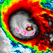
Hurricane Michael a Category 4, still strengthening this morning
Update 8:15am: The National Hurricane Center says that Michael has strengthened again this morning, with maximum sustained winds now 145mph. Hurricane Michael strengthened again overnight, and is now approaching the Florida Gulf Coast as a life-threatening Category Four hurricane with maximum sustained winds of 145mph. The National Hurricane Center is now suggesting that the storm […]
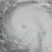
Hurricane Michael strengthens, aims toward Florida Gulf Coast
Hurricane Michael strengthened again this morning, reaching a Category 2 on the Saffir-Simpson scale with maximum sustained winds of 110mph. The storm also deepened to 965hPa as it continues to organize itself in the Southeastern Gulf of Mexico. The intensifying storm is predicted to make landfall on Wednesday as a Category 3 Major Hurricane, the most […]