-2")
Overview
Briefing
Hot and humid conditions will continue through Tuesday. Chances for showers and t-storms will increase as a cold front approaches on Wednesday. More comfortable warmth and humidity is expected late week.
Forecaster’s Discussion
Last Updated: 9:30am Thursday, July 26th 2019 by MP
Near Term (through tonight)
High pressure will provide mostly sunny skies today. 850mb temperatures around 12-13 C with deep mixing and light northwest downslope winds will support high temperatures closer to normal-in the middle 80s throughout much of the region. Humidity will still be relatively low, which will make for another beautiful mid-summer day.
Tonight, will remain mostly clear with light winds. This will result in more radiation cooling. Low temperatures are likely to in the mid 60s many of suburbs and in upper 60s to near 70 degrees in NYC and urban areas. Some of the far northern Interior valleys will likely drop into the upper 50s to lower 60s.
Hello
NYC Forecast: After the heat, strong storms possible Friday
Update [500pm]: The SPC has upgraded Friday’s severe weather threat to a Slight Risk (Level 2 on a scale of 5) in parts of New England including Northern NJ and Southeast NY. The main threats with severe storms will be lightning, gusty winds and heavy rain. We’ve got more below. Previous post follows: Another day, another Heat […]
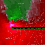
Not just scud: It was a wall cloud over Nassau county Tuesday
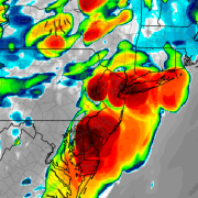
Tuesday evening, strong to severe thunderstorms moved through Eastern New Jersey and towards New York City. In fairly typical fashion, they also proceeded eastward toward Western Long Island before emerging into the Atlantic waters and weakening. The storms were particularly intense in terms of lightning, and even produced some strong wind gusts throughout the New York City […]
NYC Area Forecast: Additional strong storms possible later today
Strong and severe thunderstorms moved through parts of the Northeast states on Tuesday evening, producing frequent and dangerous lightning as well as strong, gusty winds and torrential rain. There was even a wall cloud spotted in Queens and Nassau counties, as an area of distinct rotation appeared on terminal doppler radar out of Kennedy Airport. This […]