Posts

Transient warmup expected this weekend

After a frontal passage which brought the return of arctic air earlier this week, temperatures plummeted and winds picked up fairly dramatically leading to unpleasant conditions with much below normal temperatures. Highs in the 20’s and 30’s have been common for the past few days, with wind chill values below that and the air feeling more like it typically would in mid January as opposed to mid March. The warmup which we experienced this past weekend has become a distant memory of sorts.

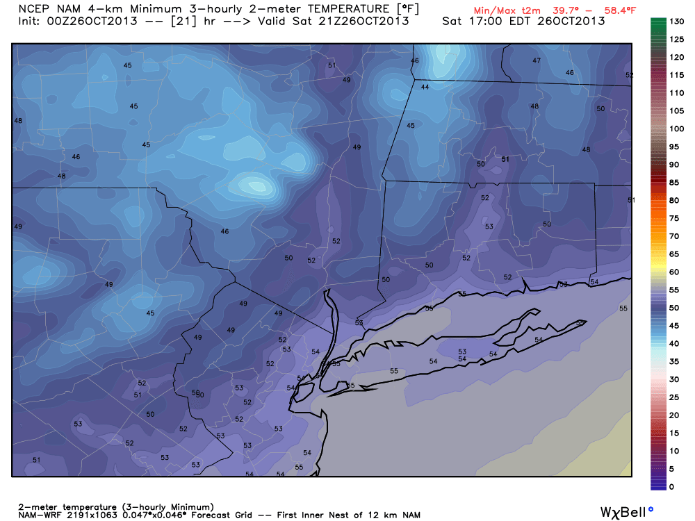
This weekend, luckily, will feature another warmup however brief it may be. Temperatures on Friday will rebound underneath increasing temperatures aloft and plenty of sun. And while a potential winter storm looms early next week, the moderation will continue into Saturday as high temperatures will move into the 50’s. The changing sun angle will make it feel refreshingly warm — but the warmup will be short lived.

NAM model showing highs in the 50's on Saturday just behind a cold front. Notice the winds picking up out of the west, ushering in a colder airmass for late this weekend.

NAM model showing highs in the 50’s on Saturday just behind a cold front. Notice the winds picking up out of the west, ushering in a colder airmass for late this weekend.

Read more

Warm weekend, severe weather to our west

Warmer weather settled into the area this morning behind a warm front, which moved northward as a result of a strong system over the Central United States. The warm weather comes on the heels of some of the coldest weather so far this season, which swept through the Northeast on Tuesday. The snow and cold seems like an afterthought at this point, with temperatures well into the 60’s and plenty of sun. But a progressive pattern in the mid and upper level of the atmosphere means the changes will continue.

For the remainder of Saturday, the main idea will be pleasant and dry. Temperatures will undoubtedly cool down with sunset (which is starting to come at an even earlier hour as we approach later November). But southwest winds, which will become increasingly apparent ahead of a cold front on Sunday, will keep the air much warmer than it has been over the past several nights. Lows will only fall into the 50’s in urban areas — and we’ll dodge a few scattered showers as well.

NAM model showing a significant mid and upper level disturbance moving through the Central US on Sunday.

NAM model showing a significant mid and upper level disturbance moving through the Central US on Sunday.

Read more

Forecast: Pleasant, crisp weekend

Another cold morning throughout the area on Saturday began what will turn out to be a pleasant — albeit cool — weekend. The cold Canadian airmass which settled into the area a few days ago has since modified a bit, but remains stout. Temperatures plummeted for the third straight night into the 20’s and 30’s across the interior, and upper 30’s to lower 40’s in urban areas. Clear skies and light winds made for favorable radiational cooling conditions. Saturday looks to feature pleasant weather, despite a noticeable wind shift from west-northwest to southwest. Winds could be a bit gustier than the past few days by afternoon.

NAM model, forecasting high temperatures in the middle 50's (cooler inland) on Saturday afternoon.

NAM model, forecasting high temperatures in the middle 50’s (cooler inland) on Saturday afternoon.

Read more

Tropical moisture could spoil weekend

The pleasant, dry and less humid weather which has settled into the area during the middle of this week, however enjoyable, looks to be short lived. Forecast models have been consistent in taking a weak (possibly tropical) system with an impressive amount of low level moisture, and tracking it from the Gulf of Mexico up along the East Coast. With the weak shortwave being scooped up by a progressive trough over the Ohio Valley, a surface low is forecast to develop and move up the East Coast beginning Thursday and continuing into early Saturday.

The system in the Gulf of Mexico, which is forecast to develop into a tropical entity by some models, is struggling amidst strong upper level winds. But it still may develop into a weak system before ejecting north and east and being absorbed into the mid level flow. The National Hurricane Center suggests the system has a 50% chance of developing into a tropical system.

Visible satellite imagery of a tropical disturbance in the Gulf of Mexico on the morning of June 5th, 2013.

Visible satellite imagery of a tropical disturbance in the Gulf of Mexico on the morning of June 5th, 2013.

The result, in terms of sensible weather for our area, will be clouds and showers beginning late Thursday and continuing through at least the first part of the weekend. The exact track of the surface low and interactions aloft will determine where the heaviest rain falls, but needless to say periods of rain are likely with the potential for some thunderstorms as well. Late Thursday into early Saturday in particular look to feature the most unsettled weather. Things look to clear out a bit during the day on Saturday, so Sunday could be salvaged if the timing holds up.

Be sure to follow our social media accounts on both Facebook and Twitter for up to the minute information and interaction.