PM Update: Chilly evening on the way

Pleasant weather had gripped the area over the last few days, until clouds moved in early this morning and showers affected the area until about noon. The dreary and rainy conditions of this morning weren’t a result of a weak or irrelevant disturbance, however. Instead, they were associated with a reinforcing shot of cold air which comes just 5 days after high temperatures reached the upper 90’s in many locations. Temperatures at the 850mb level of the atmosphere can often be a good indication as to where the weather pattern is situated temperature and sensible-weather wise, and this time around is no different. Comparing 850mb temperatures to 5 days ago yields an eye opening change: 850mb temperatures reached 22 C last Wednesday, and will fall to near 2 C overnight tonight.

Read more

Late afternoon temperature surge today, 90s tomorrow, thunderstorms Thursday

Good afternoon! As I write this article, most of the region is under mostly cloudy skies with humid conditions, as dewpoints have surged to around 70 degrees. Temperatures are primarily in the upper 70s to around 80. However, over the next few hours, temperatures should rapidly surge into the mid and upper 80s. An isolated hot spot could even hit 90.

Currently, there are showers moving through Connecticut, associated with a warm front that surged to our north. This warm frontal passage is what has brought us warmer temperatures with increasing humidity. As that system moves off the coast, skies will begin to clear from southwest to northeast. Considering how warm our 850mb temperatures are, the sunshine will allow for mixing through the surface, which leads to compression and warmth.

850mb temperatures are expected to spike to between 16-18 Celsius later this afternoon. This could yield surface temperatures in the upper 80s.

850mb temperatures are expected to spike to between 16-18 Celsius later this afternoon. This could yield surface temperatures in the upper 80s.

Above is a map of the projected 850mb temperatures, valid for 4 p.m. this afternoon. The warm front helped to spike them up to between 16-18 Celsius. On a sunny day, it is typical to add between 13 and 15 Celsius during the summer months to the 850mb temperature, to predict the high temperature at the surface. For example, if the current 850mb temperature is 17 Celsius, and enough sunshine has occurred, or is expected to occur, then adding 15 Celsius to that yields 32 Celsius — translating to 89.6 degrees Fahrenheit at the surface. The basic explanation for doing this is that if you have enough sunshine, an air parcel at 850mb can be mixed with the surface, and compress and warm dry adiabatically — through “sinking” to the surface. Without sunshine and mixing, these parcels cannot “sink” to the surface, and thus will not warm via compression. But with sunshine later this afternoon, many areas can expect mid to upper 80s, with perhaps an isolated spot hitting 90 degrees!

Read more

NASA rocket launch to the Moon will be visible from NYC tonight

A historic rocket launch will take place tonight from the NASA Wallops site in the eastern shores of Virginia. This will be first rocket launch out of the Earth from this site.

Although the best views will be in Virginia, Delaware, and Maryland, the entire NYC Metro area will still be close enough to get a great view of it. The best view is expected to be around 11:27 p.m. tonight, which is when the rocket will launch. This will be the time to look to the south.

An image illustrating the viewing scheme of the rocket, taken from the perspective of someone on the Empire State Building viewing deck. Image credit goes to universetoday.com

An image illustrating the viewing scheme of the rocket, taken from the perspective of someone on the Empire State Building viewing deck. Image credit goes to universetoday.com

Some of you may be concerned about the tall buildings obscuring the view of the rocket. However, that should not be an issue, given the close proximity of NYC. The rocket will be high enough above the horizon for all to see. Additionally, skies look to be clear tonight, making for great conditions to see the rocket.

The first sighting will be to the south, near the horizon, around fifty seconds after the launch. The rocket will then appear higher above the horizon shortly after, and then continue to get higher above the horizon, but at a slower rate (a logarithmic curve).

nyc rocket 2

An image illustrating the viewing scheme of the rocket, taken from the perspective of someone in Battery Park. Image credit goes to universetoday.com

After a few minutes, the rocket will be out of our field of view. Once again, anyone who wants to see it will need to be prepared at promptly 11:27 p.m., and look to the south!

For more detailed information on the rocket launch, check out this link. It turns out that almost all of the northeast will have some sort of view of the rocket.

Enjoy your night, everyone!


Evening update: Chilly tonight, beautiful Friday and weekend

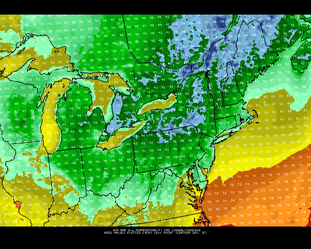
Get ready for a chilly night tonight! A Canadian High Pressure system will build into the region tonight, leading to plummeting temperatures. Lows in NYC and coastal sections will generally be in the low to mid 50s, but most non-coastal suburbs can expect lows in the upper 40s! 40s can also be expected in the Pine Barrens of Long Island. Areas well inland may even see low 40s. A very chilly wake-up tomorrow morning will yield great conditions for a long, refreshing morning run.


The high resolution NAM model showing very chilly overnight temperatures -- many areas will drop into the 40s.

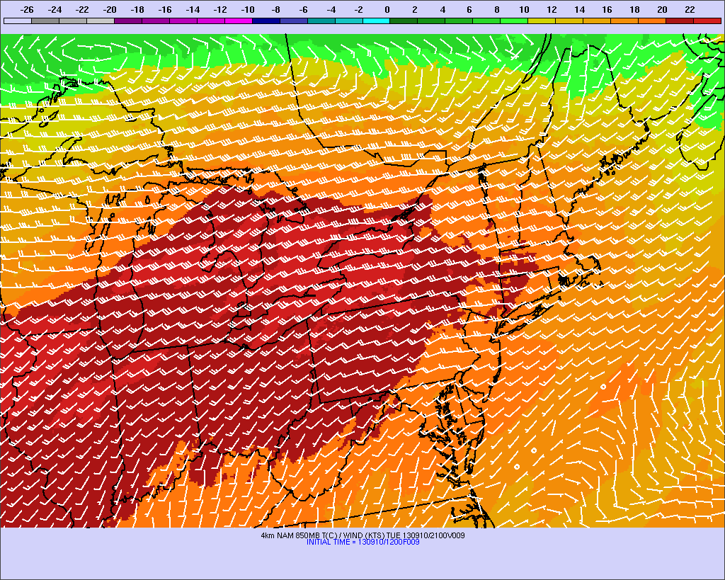
The high resolution NAM model showing very chilly overnight temperatures — many areas will drop into the 40s.

Tomorrow looks to be a beautiful autumn-like day, as temperatures will only rise into the low 70s, with a dry, northerly wind, and sunny skies. Just a great day in general for any outdoor activity, as there will be a refreshing feel to the air.

Another cool night is on tap for tomorrow night, especially in areas that are prone to radiational cooling (valleys, Pine Barrens, NW suburbs, for example) as calm winds and clear skies will lead to falling temperatures. Urban areas will probably be a tad warmer tomorrow night than tonight, but most other areas will have similarly chilly temperatures.

Saturday looks to be a bit warmer, as temperatures will rise into the upper 70s under sunny skies, with still low humidity.

There may be a few more clouds on Sunday, as another cold front approaches. Any showers should be relegated to our north, as temperatures will also rise into the upper 70s. Humidity will be up a tad as well, but nothing too uncomfortable.

Another chilly night is on expected for Sunday night, as a Canadian High Pressure system builds back in. Monday will have highs in the low to mid 70s with dry, sunny conditions.

As we head towards the middle of next week, temperatures look to warm into the 80s along with increasing humidity, and perhaps a few thunderstorm chances.

But before that arrives, enjoy the lovely upcoming weather!