Could a changing climate mean more Sandy tracks?

The effects of a changing climate on our weather have been debated for years. With each extreme weather event, more people are left wondering whether it can be attributed to climate change or not. After all, many scientists have stated that a changing climate would mean more extreme weather events. However, it is irresponsible to say that every extreme weather event can be attributed to climate change, because that would imply that there was no extreme weather before climate change began.  Remember, the weather is inherently “extreme”, and our daily averages and means are derived from extremes on both sides of the spectrum: hot and cold, wet and dry, and windy and calm. We do not hover around our average highs and lows every single day.

That being said, there may be a link to a changing climate and more extreme weather phenomena, such as the extreme track that “Sandy” took in late October, 2012 — which devastated the lives of many people, and with whom many shoreline communities are still recovering from.

Read more

PM Update: Plenty of sun, low humidity

The sun is setting this evening on a gorgeous late-summer day (or early autumn if you’re using the meteorological calendar), and the main change in terms of sensible weather has been the drop in humidity. The past several days had featured rising dew points and increasing clouds with unsettled weather. But a cold front which moved through on Tuesday set the stage for a gorgeous Wednesday — and a persistent pleasant pattern which looks to settle into the area over the next several days. Light westerly winds and clear skies were the theme Wednesday, and look to be the theme through the weekend. A reinforcing shot of cold air, arriving just ahead of a mid level atmospheric disturbance on Thursday, will make things borderline chilly on Friday morning.

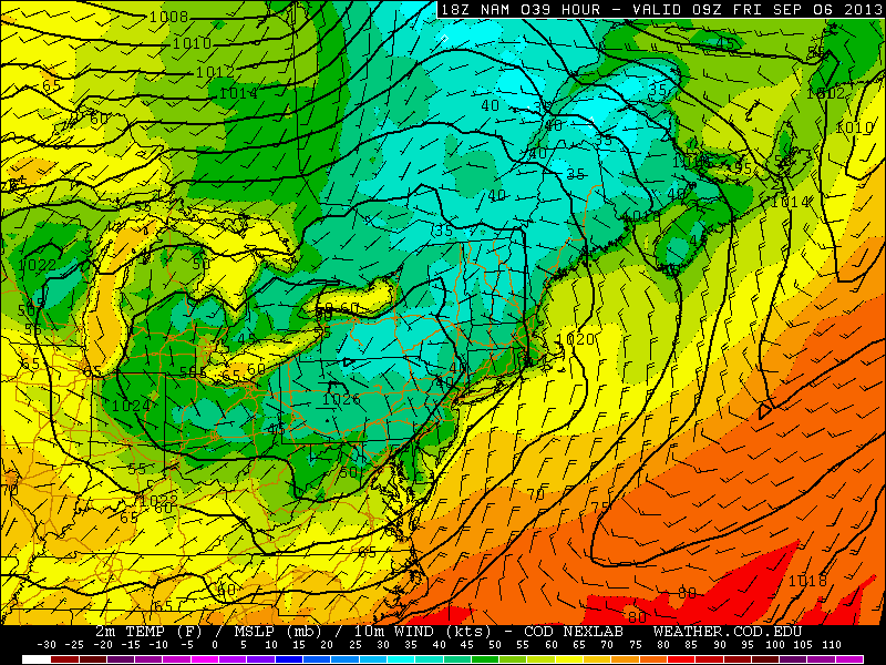
NAM model showing forecast low temperatures from Thursday Night into Friday morning. Upper 30's and 40's are common in the suburban areas of New England.

NAM model showing forecast low temperatures from Thursday Night into Friday morning. Upper 30’s and 40’s are common in the suburban areas of New England.

Forecast models show a disturbance moving through New England from Thursday into Friday, dragging a cold front south of our area into the Mid-Atlantic. The airmass from Canada which it brings along for the ride will only graze the area for a brief time, but 850mb temperatures will fall to the single digits (near zero in New England) with clear skies and light winds expected Thursday into Friday. Accordingly, forecast models show low temperatures falling into the 40’s in the interior suburbs, and 30’s in parts of New England.

Daytime highs on Friday could struggle to reach the lower 70’s — so it will certainly be feeling more like Autumn. Things recover a bit into the weekend, but the general theme of pleasant conditions with temperatures in the 70’s and perfect sleeping weather overnight will continue.


Are predictions of an active hurricane season in danger?

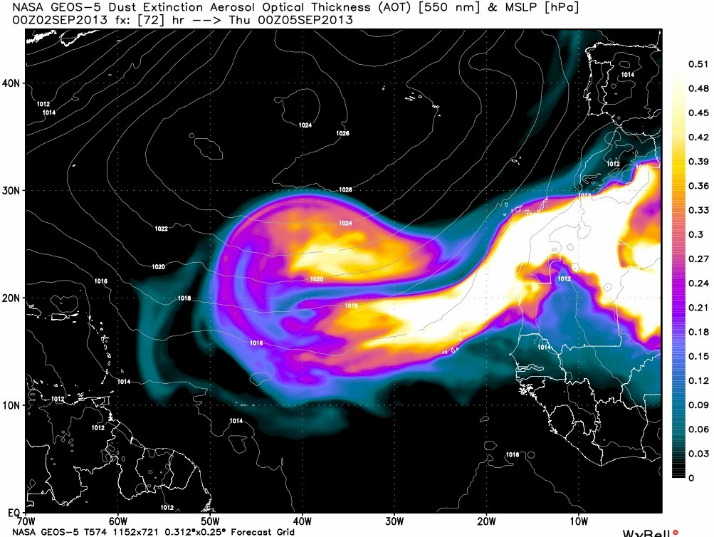
We haven’t seen a single Atlantic hurricane yet this season. This is a fact. It isn’t one that should cause a terrible amount of panic for those who predicted an active hurricane season this year, however. What should cause significant concern is the impending outbreak of African Dust in the Tropical Atlantic which should effectively inhibit the development of any hurricanes or well organized tropical systems coming off the African coast in the next week.  That will bring us into the middle of September without a single hurricane, barring a Western Atlantic or Gulf development which also seems highly unlikely during that time frame.

Forecast models are indicating another massive outbreak of African dust traveling across the tropical Atlantic this week.

Forecast models are indicating another massive outbreak of African dust traveling across the tropical Atlantic this week. Image courtesy weatherbell.

Why exactly is this African dust important? The dust is more commonly known as SAL (Saharan Air Layer), and outbreaks often occur with changing atmospheric patterns in Africa.  The SAL is known for its extremely dry air and dust content, which more often than not inhibits the development of organized thunderstorms/convection, leading to a complete lack of tropical cyclones.

Larger concentrations of dust in the air can also act as a “blanket” which restricts the sun from reaching the surface. The dust can cool temperatures of the surface, and even the sea by up to 0.5 to 1 degree cooler than average. Although some studies point to dust contributing to additional cloud development, the dry air layer often negates this development.

With the massive dust storm forecast in the Tropical Atlantic over the next few days, it seems that an above average Atlantic hurricane season is becoming less and less likely. It is hard to rule anything out in the world of meteorology nowadays, but if an above average 2013 Atlantic hurricane occurs, it will certainly be a late bloomer.


Tuesday begins transition into cooler pattern

Meteorological Autumn began September 1st with a warm, humid and unsettled weather pattern. Now, after just a few days, some significant changes are on the way. A cold front is shifting eastward off the Mid Atlantic and Northeast coast early this Tuesday morning, with some isolated showers and thunderstorms (one severe-warned storm on Long Island) possible on the Island and into Southern New England. For the rest of the area, a cloudy and drizzly start will give way to clearing skies by later this afternoon, as well as lowering humidity. The front is being driven off the coast by a mid level disturbance over the Great Lakes, which will be shunted eastward by another stronger disturbance over Southeast Canada. This feature will become important for us by later this week, as it ushers in a very cool airmass.

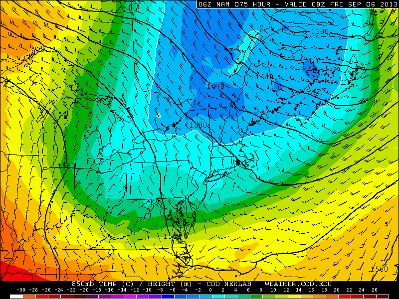
NAM model's forecast temperatures at the 850mb level in the Northeast US this coming Friday morning. Notice the values near or below zero over New England, and cold values extending as far south as NYC.

NAM model’s forecast temperatures at the 850mb level in the Northeast US this coming Friday morning. Notice the values near or below zero over New England, and cold values extending as far south as NYC.

A mid level ridge spike over the West-Central United States will allow a cutoff low over Eastern Canada to drop east-southeast, and the core of a cool airmass will clip the Northeast US later this week. Forecast models are indicative of 850mb temperatures dropping into the single digits by Thursday and Friday, with near or below 0 C readings over New England. Pleasant weather is expected, with plenty of sun, but it will certainly feel like autumn late this week.

Forecast high temperatures this week begin in the 80’s (Tuesday), but fall into the 70’s by Thursday and Friday, with overnight lows falling dramatically Thursday Night and early Friday morning, when some interior locations could fall well into the lower 40’s. With that said, the forecast looks pleasant with minimal rain chances moving forward.