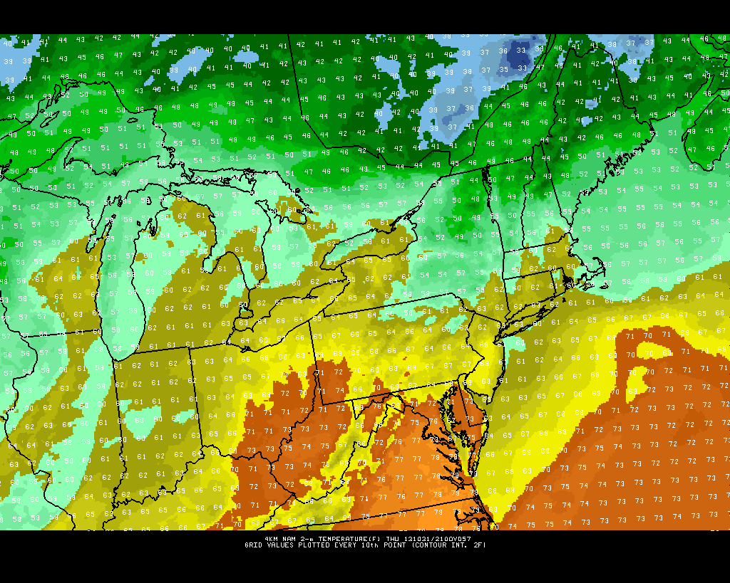
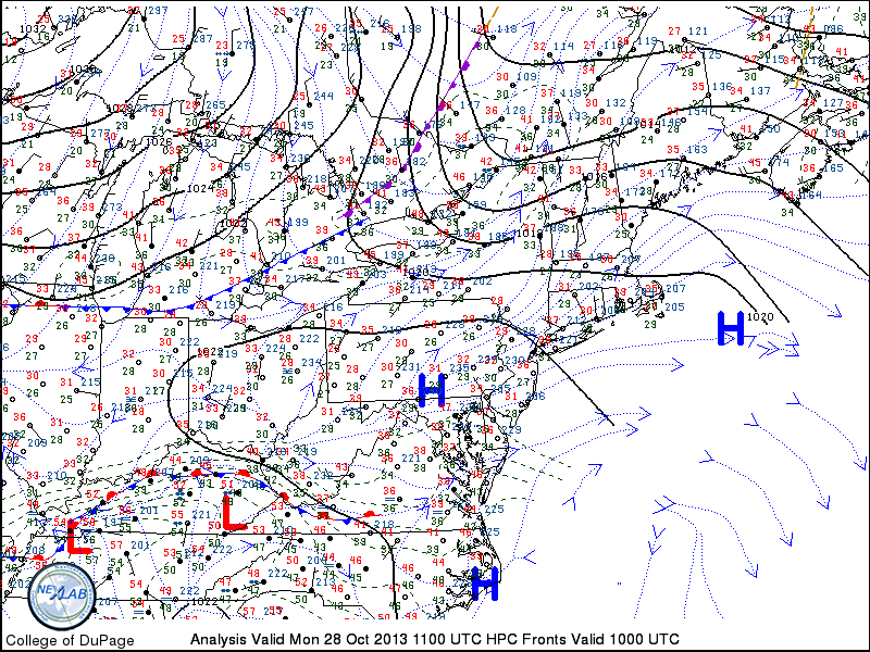
For the first Halloween in three years, the weather hazards in our area will be kept to a minimum. After a damaging snowstorm in 2011, and the recovery from Hurricane Sandy in 2012, today’s weather will feel like a major relief. Additionally, it will feel like the top of a week-long roller coaster of temperatures. Highs today will top out in the upper 60s to lower 70s, but the humidity will make it feel muggier than it has been in several weeks. A few showers are possible across the north and western suburbs later this evening.
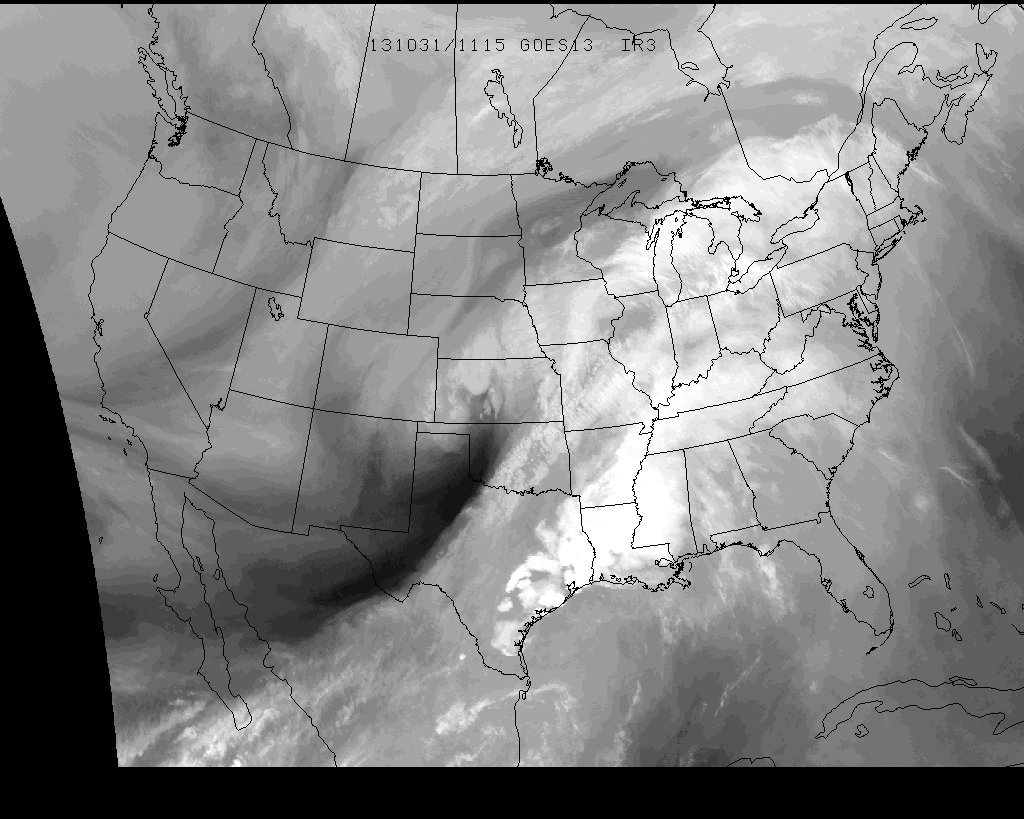
Water Vapor Satellite imagery from the morning of 10/31/13, showing moisture streaming towards the area ahead of a storm over the Central US.
The cooler than normal weather which has dominated the pattern over the past week or so will take a brief respite over the next few days, as a storm system surges towards the Central US and brings a warm front towards the region. In the meantime, pleasant weather is expected tonight — with temperatures falling from the middle 50s into the 40s overnight.
NAM model showing high temperatures in the middle to upper 60’s throughout the area on Halloween (Thursday).
One year ago today, Hurricane Sandy made landfall on the New Jersey Coast. The storm, although well predicted several days in advance, caused billions of dollars in damage as well as significant loss of life and property. In addition to our Hurricane Sandy Anniversary Archive, our forecasters have chosen ten of the most shocking images that still remain incredible a year later — showing the size, strength and impact of Sandy in our area.
The new work week began with another in a series of colder than normal mornings, as low temperatures fell into the upper 20s and lower 30s across much of the interior on Monday morning. The city and urban areas remained a bit warmer, although still chilly, with lows dropping near 40 degrees. Monday will turn out to be a pleasant autumn day, as temperatures warm into the upper 50’s to lower 60’s by afternoon. A light southwest breeze will make it feel plenty comfortable, and less chilly than the past several days which featured windier and cooler conditions.
Northeast US Surface Analysis and observations from the morning of October 28, 2013 showing high pressure in control and a cold front approaching.
A cold front dropping southward through New England, however, will provide a reinforcing shot of cooler air by later Monday. Associated with a disturbance over Southeast Canada, the front isn’t expected to feature any precipitation. The wind shift, however, will be noticeable. By Tuesday, winds will have swung around once again behind the front, and will be blowing out of the north. High temperatures will once again struggle into the lower to middle 50’s — making Monday seem like a much warmer day in comparison.
Hi friends! Our website uses cookies to provide an optimal browsing experience for you. New "Cookie Consent" laws mandate us to inform you of this. As long as you're cool with it, just hit OK. You'll only see this message once.
We may request cookies to be set on your device. We use cookies to let us know when you visit our websites, how you interact with us, to enrich your user experience, and to customize your relationship with our website.
Click on the different category headings to find out more. You can also change some of your preferences. Note that blocking some types of cookies may impact your experience on our websites and the services we are able to offer.
Essential Website Cookies
These cookies are strictly necessary to provide you with services available through our website and to use some of its features.
Because these cookies are strictly necessary to deliver the website, refusing them will have impact how our site functions. You always can block or delete cookies by changing your browser settings and force blocking all cookies on this website. But this will always prompt you to accept/refuse cookies when revisiting our site.
We fully respect if you want to refuse cookies but to avoid asking you again and again kindly allow us to store a cookie for that. You are free to opt out any time or opt in for other cookies to get a better experience. If you refuse cookies we will remove all set cookies in our domain.
We provide you with a list of stored cookies on your computer in our domain so you can check what we stored. Due to security reasons we are not able to show or modify cookies from other domains. You can check these in your browser security settings.
Other external services
We also use different external services like Google Webfonts, Google Maps, and external Video providers. Since these providers may collect personal data like your IP address we allow you to block them here. Please be aware that this might heavily reduce the functionality and appearance of our site. Changes will take effect once you reload the page.