Nor’easter to bring rain, wind over next several days

Sunny, warm and pleasant conditions will become a distant memory during the second half of this work week. A coastal system, or Nor’easter, will develop off the Mid-Atlantic coast today and shift slowly northward. The developing system is actually the weak remnants of Tropical Storm Karen, now a mid level disturbance shifting up the Eastern Seaboard. Although not featuring a very strong center of low pressure, the system will push north with a tight gradient developing between the low pressure area and the high pressure holding firm to the north. The result will be east/northeasterly winds (an onshore flow) for a prolonged period of time, as well as gusty winds and periods of rain.

Gale Warnings and Coastal Flood Statements have been issued by the National Weather Service in advance of the system.

Read more

Comet ISON, expected to thrill, may be dying

What was once heralded as the potential “Comet of the Century” may be an equally large disappointment. Although previous reports of the comets demise may have been significantly exaggerated, new information reveals that not only is the comet underwhelming as it races towards the sun — it is also smaller than expected, and tracking in a very dangerous area for comets that wish to survive.

The comet recently passed near Mars, where NASA utilized several imaging tools to view it. It was this imaging, coupled with thousands of others which have been taken over the last several months, which revealed that Comet ISON may not be what it was initially perceived to be. The comet, which was discovered over a year ago and began brightening ahead of schedule, would have eventually reached a magnitude of -17 if it had continued to brighten at such a rate. But, over the last 4-6 months, the comets brightening has “stalled”. And this is bad, bad news for those who are hoping for a bright comet this autumn and winter.

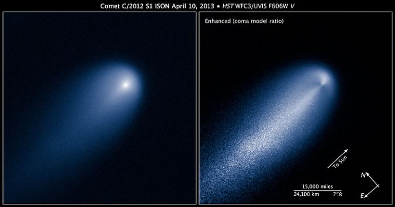
Comet ISON as observed by the Hubble Space Telescop, near Jupiter, in April of 2013.

Comet ISON as observed by the Hubble Space Telescope near Jupiter, in April of 2013.

Read more

Front passes, coastal low threatens late week

Cooler, less humid and more crisp air settled into the area on Tuesday behind a strong cold front which steamed through on Monday evening. The humidity and instability on Monday, which helped lead to strong to severe thunderstorms and a few damaging wind reports in New Jersey and New York, was a distant memory as it was swept seaward with the frontal passage. The new airmass is characterized by a large high pressure system, which stretches from the Mississippi Valley to Northern Maine and into parts of Canada. Pleasant, fall-like weather is expected on both Tuesday and Wednesday with highs in the upper 60’s to near 70 and chilly evenings and mornings.

A wrinkle in the forecast later this week is the development of a coastal storm system, which forecast models have been hinting at for several days. A weak mid level disturbance (the remnants of TS Karen) shifting northeastward will eventually track near the Mid-Atlantic Coast, developing a weak surface low offshore. The north/northwestward extent of the storm system, and associated precipitation shield, remains in question — and has significant impacts on our areas forecast. A farther northwest track would mean the potential for more significant rain in our area, while a weaker or farther southwest track (as a result of the strong high pressure holding its ground over New England), would mean unsettled weather but no heavy flooding rains.

NAM model showing an offshore coastal low producing unsettled weather and periods of rain throughout the area on Friday.

NAM model showing an offshore coastal low producing unsettled weather and periods of rain throughout the area on Friday

Regardless of the systems eventual track, unsettled weather looks likely to return by the tail end of this week beginning on Thursday with increasing clouds and a chance of showers. Periods of rain are likely, especially along the coast, from Thursday through Saturday — and depending on the northward progression of the system, the rain may be steady or heavy at times. Stay tuned for further details, and refining of the forecast, as we approach the event.

Live Thread: Tornado Watch until 5pm

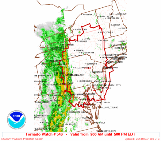
Ahead of an expected severe weather threat including the potential for strong winds, the Storm Prediction Center has issued a Tornado Watch this morning for all of New Jersey, Southeast New York and the NYC Metro Area. The Tornado Watch is in effect from 9:00 am this morning until 5:00pm this afternoon.  A tornado watch means conditions are are favorable for severe thunderstorms capable of producing tornadoes in and around the watch area. Although not immediately likely, a higher than normal chance exists for gusty winds and isolated tornadoes this afternoon.

The Storm Prediction Center issued a Tornado Watch for much of the area this morning, in effect until 5:00pm. The area within the red box is included in the watch area.

The Storm Prediction Center issued a Tornado Watch for much of the area this morning, in effect until 5:00pm. The area within the red box is included in the watch area.

Earlier this morning, our article discussed the potential for severe weather this afternoon. A strong cold front approaching a very warm and moist airmass will be the focal point for the development of storms. However, more importantly, strong shear exists in multiple levels of the atmosphere near the approaching cold front. This will aid in storm organization, and amplify concern for strong winds mixing down to the surface later today. Although not likely to be widespread, an additional threat may exist for isolated tornadoes within an expected line of strong to severe storms.

Stay tuned this afternoon to this post, which will be automatically updated by our forecasters. Additionally, we will relay all additional watches and warnings via social media accounts on Facebook and Twitter.

Read more