-2")
Update: October NAO and what it means for winter
As we have alluded to in previous articles, the weather pattern across the globe is currently undergoing changes. A lot of this has to do with recurving Typhoon Wipha, as the large storm generated a trigger to produce a large ridge ahead of it. This helps to create a more amplified pattern, slowing things down. A slower global pattern is what tends to lead to more blocking, and the blocking that we are seeing this month could be a very important player as we head towards winter.
The reason it’s important is because there is a significant correlation — especially recently — between a -NAO in October and a -NAO during the following winter. One reason among many for this is because a -NAO pattern will often establish itself in October, relax a bit during November, and then re-establish itself during the winter. Our previous article highlights the detailed research and correlations, which will help you contextualize what is being written in this article.
The prudent question to ask now would be how the NAO has been doing so far, and if it will stay negative for the rest of the month.
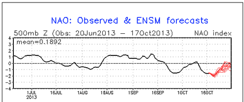
The NAO has been negative this month, and should continue to remain negative for the rest of the month. The black line represents the observed values, and the red lines represent the forecast values from the GFS ensembles.