PM Update: Milder this week, more wintry by weekend

The trend towards milder temperatures continues this week, as high temperatures rose into the upper 40’s and the 50’s throughout the area on Tuesday. The modifying airmass and stagnant high pressure are initially to blame this week, with no reinforced source of cold arctic air. But by Wednesday into Thursday, the warm air will be forced northward by a surging warm front and associated storm system moving through the Great Lakes.

The warm front moving northward on Thursday will bring an unseasonably warm airmass with it. Southerly winds will pump in very mild air, with temperatures rising into the 60’s by Thursday afternoon. But the warmth will be short lived, as a cold front moving through the area on Friday will mark the beginning of another infiltration of arctic air.

NAM model showing high temperatures in the lower to middle 60's in parts of the area on Thursday afternoon.

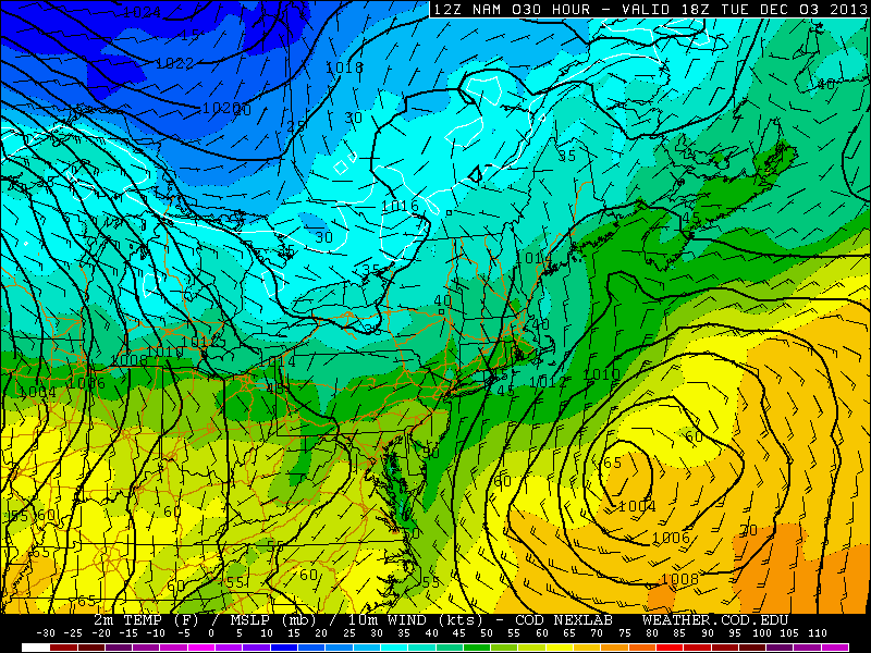
NAM model showing high temperatures in the lower to middle 60’s in parts of the area on Thursday afternoon.

Read more

The forecast headache that is next week

Arctic air will be pouring into the Rockies, Pacific NW, and Northern Plains over the next several days as the mid level ridge centered near Alaska energizes. Whenever we see the Alaskan ridge, it suggests that cross polar flow has initiated from Siberia to North America due to the clockwise flow around that mid level high. This pattern is polar opposite of what we saw the past two winters over Alaska. Remember the stories of yards of snow and endless bitter cold in AK? That has not been the case as of late due to the strong positive height anomaly at the 500mb (18,000ft) level of the atmosphere.

The composite for November 2013 illustrates the ridging that has been taking place in the northeastern Pacific and AK, exactly where a trough pattern dominated in 2012.


comphour_69_119_111_128_335_15_44_29

Read more

PM Update: Increasing clouds, becoming milder

Low clouds and fog were the main story early on Monday morning, with plenty of areas reporting low visibility. The cloudiness also kept temperatures a bit cooler to start. But by Monday afternoon, the low clouds had lifted and most areas were reporting sunshine. Temperatures warmed into the upper 40’s to near 50, which felt especially refreshing after several days of cold weather. The warmth will continue to slowly build this week.

However, with the building warmth will come a variable increase in cloudiness. With a weak storm system offshore, low clouds will increase again early from late Monday night into early Tuesday morning, with the potential for fog in the morning once again. Temperatures are expected to top out in the 50’s — but not until the late afternoon when the clouds burn off a bit.

NAM model showing high temperatures reaching near 50 degrees on Tuesday afternoon, with a storm system offshore.

NAM model showing high temperatures reaching near 50 degrees on Tuesday afternoon, with a storm system offshore.

Read more

NYC Forecast: Slow warming trend this week

Cold weather has become a staple in the area forecast over the past several days, with the only warmup coming during a significant storm system — which produced the first rainfall of over 1″ since September in New York City. Otherwise, though, it has been a cold and dry pattern which has dominated the past several weeks. Some changes are in order during this week, but the start will be characterized by a slight warmup. Monday will be the first of a few “warmer” feeling days, with highs in the 40’s to near 50 in many spots as well as plenty of sun.

During the week, the airmass will slowly modify as a high pressure continues to control the pattern. High temperatures will reach into the upper 40’s and lower 50’s by the middle to second half of the work week. With the warmup, will come a chance of precipitation and the likelihood of clouds, which will move into the area as a warm front moves nears on Thursday.

NAM model, forecasting high temperatures in the upper 40's to lower 50's on Monday.

NAM model, forecasting high temperatures in the upper 40’s to lower 50’s on Monday.

Read more