Clouds, showers to begin the new week

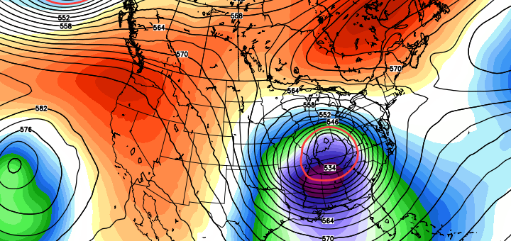
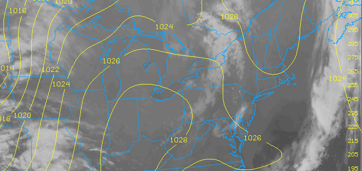
Plenty of sun, and warm temperatures, dominated the areas weather late last week into this past weekend. But late Sunday, mid and high clouds took over owing to an approaching disturbance to the west. This disturbance is over the area today — nestled between a tight mid level atmospheric flow and bringing clouds and showers with it. The unsettled weather will also bring cooler temperatures — topping out in the upper 50’s to lower 60’s. The air will feel cooler and damp, however, with winds off the cooler ocean waters.

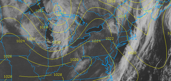
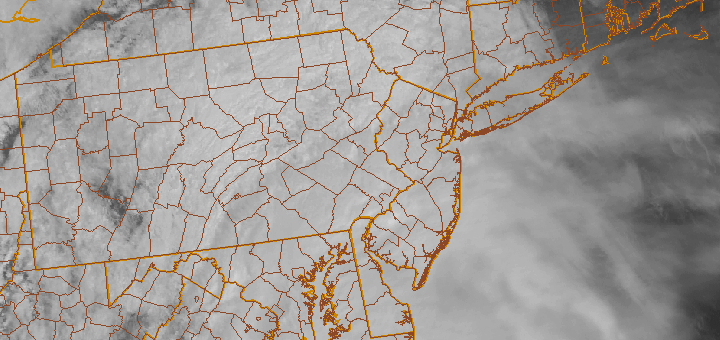
The showery and cloudy conditions are expected to persist through the early week, but will become less numerous on Tuesday and taper off completely by Wednesday. By mid week, the sun should make a return. Winds will remain out of the east, so the air will still have a bit of a chill to it, but the sun and temperatures in the 60’s will be pleasant compared to the damp and dreary conditions that the week began with.

Today: Cloudy with showers likely. Highs in the upper 50’s to lower 60’s. Southeast winds around 15 miles per hour. Chance of precipitation 80 percent.

Tonight: Cloudy with showers likely. Lows in the upper 40’s to lower 50’s. Southeast winds around 15 miles per hour. Chance of precipitation 60 percent.

Tuesday: Mostly cloudy with a chance of showers. Highs in the upper 50’s to lower 60’s. Southeast winds around 15 miles per hour. Chance of precipitation 40 percent.

Wednesday: Partly cloudy. Highs in the mid 60’s. Southeast winds around 10 miles per hour.

Blocking episode may create forecast headache

Blocking, both over Eastern Canada and in the high latitudes, more often than not means a forecast headache for our forecast area. We’ve seen it on many occasions with winter storms — as the strong blocking highs create anomalous weather patterns. We saw it with Hurricane Sandy, and the Nor’Easter that followed. And it seems that we may see it again, as we head towards the first week of May.

Forecast models are coming into agreement on the potential for an anomalous blocking pattern to develop over Eastern Canada and the Northwest Atlantic towards Newfoundland. With a shortwave trough predicted to be over Central Canada at that time, the trough may be forced underneath the block into the Ohio Valley and the Mid-Atlantic/East Coast. This would create the opportunity for a “cutoff low” and possibly even a coastal storm — with widespread below normal temperature anomalies wherever the cutoff low and upper level trough tracks.

At this range, the question becomes: How strong will the blocking be, and where will it develop? The positioning of the block, as well as its strength, will have a great deal of impact in determining where the cutoff low will eventually track. This will, in turn, have major impacts on the sensible weather forecast for our area. Needless to say, the potential is there for a prolonged period of showers and unsettled weather — as well as a coastal storm — if the cutoff tracks near our area. If it remains farther south, we may be spared the worst effects.

Forecast models are still struggling with the positioning of the block and positioning of the cutoff low. The Euro (or ECMWF), for example, has the cutoff low staying well to our south while the GFS and Canadian models bring it closer to our area with a prolonged period of rain in the Mid-Atlantic states.

In situations like this one, forecasters can utilize ensembles to see the variance amongst forecast models. In this case, we can check out the GFS Ensembles — which show the average height anomalies at 500mb (mid levels of the atmoshpere) on the left, and the “spaghetti” plot of each ensemble on the right. It is easy to see that most ensembles agree on the strong block developing over Newfoundland and Eastern Canada, but the exact positioning of the upper level trough over the Central US is less certain.

Forecasters will certainly be monitoring the models over the next several days, so be sure to stay tuned for updates on the potential unsettled pattern as we head towards next week. For now, enjoy the pleasant weather through the weekend!


Pleasant weather through the weekend

For once, we have actually had sustained spring-like weather, as opposed to jumping rapidly from winter to summer, like we have in past years. This trend should continue today and through the weekend, as the entire area will experience sunny skies and temperatures into the 60s, and maybe hitting 70 in warmer inland locations this weekend. There is no threat of precipitation for the next several days.

The 1028mb high pressure system to our southwest will initially provide northerly winds for the morning hours, as clockwise flow around the high in the Ohio Valley yields northerly winds. However, once the high pressure moves eastward, the same clockwise flow around that high will instead yield westerly winds as we approach the afternoon hours. This will allow for a dry, downsloping flow, keeping skies clear, as downsloping yields sinking motion and thus no lift for clouds. The westerly winds will also help to keep the seabreeze to a minimum, so coastal locations will also get into the 60s and stay there for the whole afternoon. This bodes well for people who enjoy going to the beach during the sunset.

As we head into Saturday, that high pressure will continue to move eastward, so that the clockwise flow around it will actually help to turn the winds towards the southwest as the afternoon progresses. This will help warm many areas from NYC and westward to readings near 70. Coastal regions will also have a nice initial burst of warmth, but later in the afternoon once the southwest flow becomes more prevalent, the seabreeze and onshore flow will be allowed to have a bit more of an influence, thus cooling temperatures on Long Island in the late afternoon hours. Fortunately, the initial warmth should prevent the cooling temperatures from meeting their dewpoint, thus eliminating the fog threat that ruined the afternoon for coastal sections on Wednesday.

Sunday should expect much of the same conditions as we had on Saturday, except for the fact that the winds might be more due southerly, perhaps increasing cloudiness and knocking down temperatures into the upper 50s for coastal regions in the afternoon hours with the marine layer threat. Other than this possibility for coastal sections, all locations west of NYC should hit the 70 degree mark and perhaps exceed it.

Today: Sunny with a high near 65. Light northerly winds will shift to the west between 5-10mph.

Tonight: Clear skies with a low around 45 and light west-northwest winds between 5-10mph.

Saturday: Sunny with a high near 71. Light west and northwest winds will shift to the southwest during the afternoon.

Sunday: Partly sunny with a high near 68 and light southerly winds.

Prolonged stretch of pleasant weather expected

Spring started off cooler than normal, but since has been a roller coaster ride with temperatures fluctuating between above normal and below normal. Rather typical for Spring — with cold fronts and swings in temperatures. Missing, however, has been the presence of any widespread heavy precipitation. This April, so far, falls under the top 10 driest of all time in New York City. Over the next week, we will make a run for history..and likely will reach it given the forecast for pleasant and dry weather.

A high pressure system will take control of the weather pattern beginning on Thursday — and will hold a firm grip into the early and middle part of next week (no, that’s not a typo). Temperatures will rise into the lower to middle 60’s for highs — but will moderate each day moving forward. For example, by Sunday, many areas could see highs into the 70’s. Light winds and the lack of any precipitation will make this one of the more prolonged stretches of pleasant weather in recent memory. Isolated showers and thunderstorms will begin to become a possibility during the afternoon (typical pop-up storms) this weekend into early next week, but no widespread rain threats are expected in the near future.

Today: Sunny with a high near 64. Northwest winds around 10 miles per hour.

Tonight: Mostly clear with a low in the lower to middle 40’s. Light west-southwesterly winds.

Friday: Sunny with a high near 66. Northwest winds around 5 miles per hour.

Saturday: Mostly sunny with a high approaching 70. Light west-northwest winds.