Gradually improving, slightly warmer weather

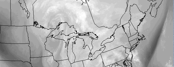
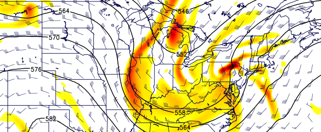
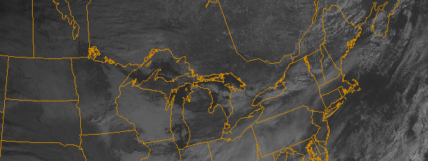
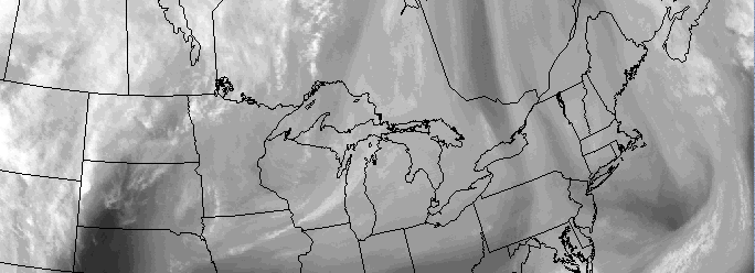
The same mid-level cutoff low that helped bring the heavy rain and strong winds on Tuesday, as well as multiple days of snow showers since, is still meandering in the vicinity of the Northeast US today. This has helped to keep an island of cold in an otherwise sea of warmth across much of the US, as well as instability and moisture to produce wrap-around snow showers.

Impressive lapse rates have remained over the region over the past few days, allowing for the continuation of snow showers and squalls. They’ll be much more isolated on Friday, however, as the upper level low finally begins to pull away. As it does so, it will remove our area from the pocket of stronger instability. So, we expect highs in the upper 30’s to near 40 on Friday with a much lower chance of snow showers — in fact, cloudy to partly cloudy skies should be the general rule.

Read more

Multi-hazard Nor’Easter expected Tuesday

A significant storm system, characterized by a deepening low pressure with prolific moisture, will move from the Western Atlantic to a position very near New York City on Tuesday. As a result of a mid level atmospheric phase, the storm system will feature intense mid and upper level dynamics. The system is forecast to strengthen with a minimal central pressure near 1012mb today, falling into the mid 990’s mb by Tuesday. With a storm track near our area, and the dynamics involved in the system, multiple weather hazards are anticipated both near our area shores and even inland throughout the interior portions of the area.

Precipitation could begin as early as Monday morning along the coasts of New Jersey and New York as moisture streams inland, owing to an onshore flow. But as the storm system is tugged inland from the Western Atlantic, as a result of the phase in the mid levels of the atmosphere, warm air advection and increased moisture will surge heavier and steadier precipitation toward the coast and eventually into New York City, New Jersey, Southeast New York and Connecticut. Enough low level cold air could hold on across the higher elevations of the interior to allow precipitation to begin as snow, sleet or freezing rain — but this will only be brief as mid level and low level warming transitions precipitation to rain quickly.

The event will create multiple potential hazards throughout our area on Tuesday as the low pressure system tracks nearby. We’ve broken them down here.

Read more

Coastal storm likely early next week

Although it may seem like we’re beating the same old drum, here we are again — a significant coastal storm looks increasing likely early next week. Forecast models have come into much better agreement on the evolution of the mid and upper level atmospheric pattern across the Continental United States from late this week into this weekend. After a weekend rain event and weak disturbance, two additional disturbances in the mid levels of the atmosphere will move eastward from the West Coast. The first will settle into the Southeast States, while the second will be dropping southeastward from the Northern Plains into the Mississippi Valley. The two disturbances will interact, and possibly phase, early next week — and the end result will be a strengthening Nor’Easter on Tuesday.

The questions, now, become more related to specifics and the sensible weather that these features will bring. The strengthening coastal storm is likely to feature tremendous amounts of moisture and impressive dynamics aloft, but the exact track and intensity of the storm system will obviously significant impact what we see in our area. At this time, the potential is heightened for a multi-hazard Nor’Easter to impact our area from Tuesday into Wednesday, but our confidence in the areas impacted highest and the hazardous weather that our entire area experiences is low.

Read more

Rainy, unsettled weekend expected

Although the pattern we have settled into may not necessarily be a “cold” one, it certainly is active. And after a Nor’Easter not much more than a week ago, we’ll deal with another low pressure system this weekend after making our way through a few weaker ones over the past 7 days as well. The low pressure system over the next few days will feature warmer air, southeasterly winds with marine influence, and plenty of rain — all of which will come on Friday and Saturday, much to the despair of those who were ready to head out on the town at the end of this work week. Not that some rain should stop you, really.

Initially, warmer air and partly cloudy skies will rule the day on Thursday. That general theme may even remain in control on Friday morning. But during the mid morning hours, winds will flip to southeasterly drawing in more moist ocean air. Low clouds will increase, winds will become a bit more blustery, and drizzle will work its way into the area. This damp, drizzly and showery weather will continue on and off during the day on Friday. Temperatures, meanwhile, will rise into the upper 40’s throughout the area. Steadier precipitation will likely begin to approach the area later in the afternoon on Friday.

Read more