Friday Forecast: East winds briefly take over

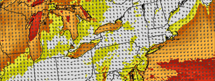
It’s finally Friday! Temperatures started out a good bit cooler today than they have the past several, with lows in the 40’s across the interior and temperatures in the low 50’s even in the city and urban areas of Northeast New Jersey. They will, of course, rise this afternoon — but not as much as the typically would. Highs will only top out in the 60’s throughout much of the area. The reason? The east winds are at it again. Low level winds will flip to easterly, an onshore flow, this morning — and put a lid on temperatures while keeping the air cool.

Forecast models are fairly adamant on the idea that there won’t be much in the way of low clouds initially, so we won’t be sitting in fog and dreary weather all day today. These clouds will likely develop mid-day near the area beaches and shores, as they almost always do when there is an onshore flow. But even where the sun is out,  it will feel quite cool — especially given the fact that temperatures were hot and humid just over a week ago. The brisk, cool weather won’t dominate the weekend, however. The winds, which flip to easterly today, will continue turning to southerly on Saturday and Sunday — ushering in warmer and slightly more humid air ahead of a frontal system.

Read more

What if the 1821 Long Island Hurricane happened today?

The details of this storm remain fuzzy. Based on first hand accounts and somewhat spotty meteorological data, we can only know one thing — the Long Island Hurricane of 1821 was a big deal. It was one of only four known tropical cyclones to make landfall in New York City. It made landfall just several hours prior, near Cape May, New Jersey as what would now be defined a strong Category 3 Hurricane. And then, it tracked northward essentially along the Garden State Parkway, briefly back out into open water and then through New York Harbor. The storm struck at low tide, but still produced a near-30 foot storm surge along much of the New Jersey Coast, obliterating any development there and causing significant overwash past the shores.

Obviously, this storm occurred in 1821 — way, way before any major development by modern standards. Areas which were hammered with unprecedented wind, rain and storm surge from the Hurricane of 1821 now are populated by the millions — with incredible development and modernization. A new report, from the ReInsurance behemoth SwissRe, details what would happen if a storm similar to the Hurricane of 1821 occurred today. And the results are not good.

Read more

NOAA announces Summer 2014 was warmest ever on Earth

2014 has been officially announced as the warmest summer on Earth, since records began in 1880. The newest climate report published by the National Climate Data Center at NOAA released the information today as well as other in-depth information from around the world for this summer and its individual months. In addition to the summer as a whole being the warmest on record, August 2014 was also the warmest August ever recorded on Earth, finishing 0.75 degrees Celsius above the 20th century average.

While the summer in our area was relatively average, if not cool, the ocean waters throughout the globe and different land areas worldwide led to the wildly above-average temperatures. The summer as a whole finished 0.71 degrees Celsius above the 20th century average. The ocean temperatures set a record high anomaly for all months.

Read more

PM Update: Gorgeous weather continues, 80 degrees Sunday

While the first day of Fall is technically not until Tuesday, September 23rd, we have already had a lovely taste of fall and this should continue for the foreseeable future. In the wake of yesterday’s rain, an area of high pressure has filtered in, leading to sunny skies and temperatures in the low 70s. Some cumulus clouds are forming to the west as evidenced in the latest satellite — but those will not be producing any rain.

With clear skies and calm winds tonight, temperatures should fall quickly into the 50s, and perhaps into the 40s in the coldest spots.

Moving forward to tomorrow, the weather looks very similar today — but with perhaps a few more clouds and a touch warmer — with temperatures in the mid 70s. Winds shifting a bit more northwesterly as a high pressure system approaches will allow for a tad more downsloping flow, explaining the warming. On Thursday night, the high pressure will pass directly to our north, shifting the winds to the north and then the northeast, which will help to make conditions relatively chilly on Thursday night and Friday.

Read more