Cold air filters in, light snow likely this week

Temperatures fell back towards normal on Monday (it wasn’t hard to notice the lack of warmth and return of colder wind), with highs generally only reaching the mid to upper 30’s throughout the area. While this certainly felt more chilly than what we experienced this weekend, the real chill is still on the way this coming Tuesday and is expected to continue through the week. More interestingly, a parade of disturbances is likely to traverse the country from the Pacific northwest towards the East Coast, providing multiple opportunities for wintry precipitation in the area.

The main difficulty in the forecast will be the exact track of these systems, owing to the positioning of the Polar Vortex which is forecast to remain parked over Southeast Canada. This positioning allows for plentiful cold air, but also suppresses the baroclinic zone and favored storm track to our south. Forecast models, picking up on this and the southward sag of the arctic front, have trended farther south and east with the storm system forecast to track near the East Coast on Wednesday — the first in the parade. Currently, light snow still seems likely due to favorable jet streak positioning, but the heaviest precipitation is expected to remain offshore.

GFS model showing Wednesday's potential system passing mostly seaward.

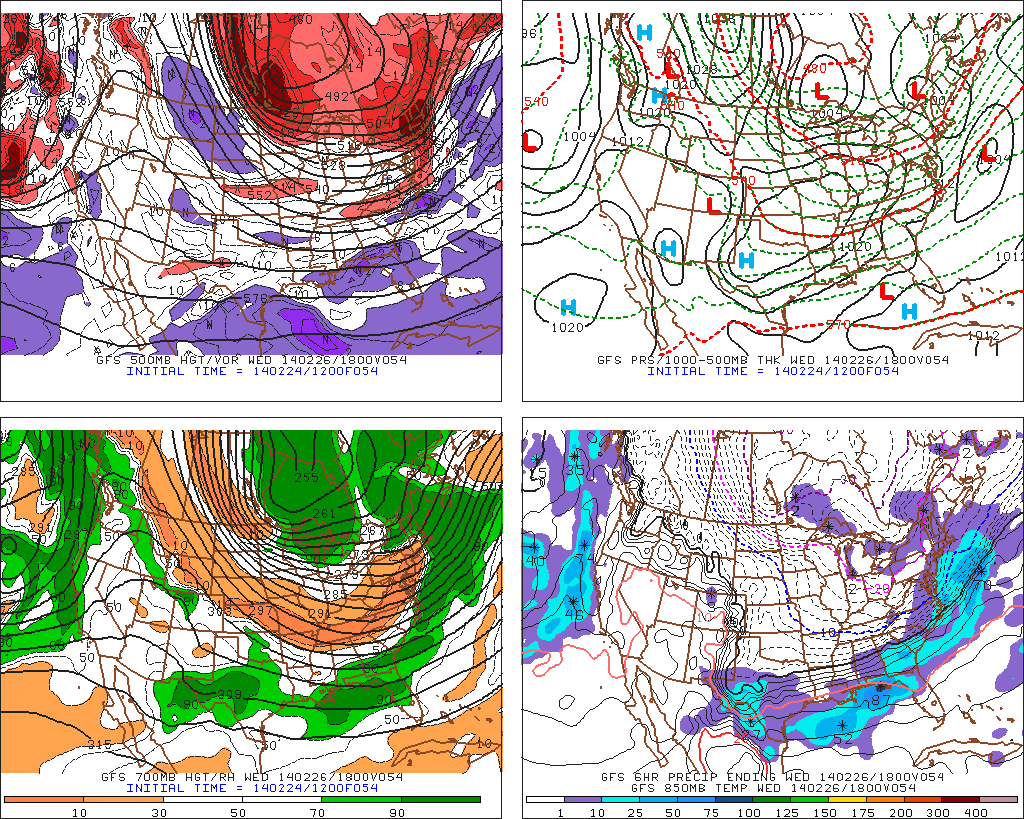
GFS model showing Wednesday’s potential system passing mostly seaward.

Read more

Colder, more wintry weather set to return

It was a wonderful Saturday. High temperatures in the 50’s, plenty of sun and no precipitation to speak of. The first “winner” of a day in several weeks, in fact. The unfortunate news is that it won’t last long, and in fact the weather from Saturday will become a distant memory by the middle of the upcoming work week. The winter pattern, which dominated for the last month or two, will return — and remain relatively relentless.

Colder temperatures will begin filtering into the area by Sunday, as a frontal boundary nears the area. All won’t be lost, still, as high temperatures will reach back into the 40’s and 50’s just ahead of the front. But as the front nears, temperatures will begin to drop — and winds turn to a much cooler direction. By late Sunday Night into Monday, forecast models are in agreement that light precipitation will begin to develop just behind the cold front, beginning as rain and likely ending as snow in some locations away from the coast.

NAM model forecasting precipitation along a frontal boundary on Monday morning.

NAM model forecasting precipitation along a frontal boundary on Monday morning.

Read more

Milder air will give way to rain, storm threat

A relentlessly active pattern continues as we make our way into the latter half of February. Despite warmer air moving into the area on Thursday and Friday, a significant storm system in the Central United States will move northeastward towards the Great Lakes and drag a cold front through the area later on Friday. The weather on Thursday, in sensible terms, will be much milder than usual with temperatures both aloft and at the surface increasing and plenty of sun expected. We’ll consider it a bit of a consolation prize for the volatility of the pattern over the last several weeks. High temperatures are expected to reach close to 50 degrees in many locations (although cooler near the shore, as usual for this time of year) which will feel almost balmy compared to what we’ve become accustomed to.

Friday, however, looks to be another active weather day in the area with multiple hazards. First and foremost, the Storm Prediction Center has placed parts of Central and Southern NJ in a Slight Risk for severe thunderstorms. As mentioned above, a cold front will move through the area later on Friday. Increased forcing/lift along this front will act as an impressive trigger for storms — and southerly flow ahead of the front will likely provide adequate instability for at least elevated thunderstorms in those areas. A very impressive mid and low level jet just above our heads provides the potential for strong winds to mix down to the surface in any thunderstorms. Although widespread strong/damaging winds aren’t expected, a few severe gusts seem likely but will remain isolated. The threat drops off farther north where instability is less, although rumbles of thunder and heavy rain are still likely along the front.

Hazards overview for Friday, February 21 2014.

Hazards overview for Friday, February 21 2014.

Read more

Active Pattern To Reload For Late February and Continue Into March…

The transient relaxation in the energizer bunny winter of 2013-14 is occurring this week, with temperatures liable to soar through the 40s and possibly 50s for Friday. However, like all warm periods this winter, we have been able to see the beginning of the next cold outbreak as the warmth moves in. And so the coming 10 day period is a microcosm of our winter’s progression to date, one which featured strong polar/arctic outbreaks interspersed with sharp yet temporary spells of mild weather.

The reload is actually occurring during the thaw, as global indicators once again resume their base state of the winter. Those who were hoping for the current shot of warmer temps to carry over into spring will be disappointed, but don’t fret, spring will come eventually (the question is when exactly). Since November, the EPO has been strongly negative, and we’ve seen the results of that with a powerful Alaskan block which effectively shuts-off the Pacific-maritime flow into the CONUS. As discussed from earlier in the season, the negative EPO would provide the impetus for driving Siberian air into North America regardless of the magnitude of blocking (lack thereof) on the Atlantic side. We’ve clearly seen how the EPO has been able to dominate the pattern even with a +NAO, much like we saw in 1993-94, 2008-09, and 1983-84, a few of the main analog years for this winter.

Going forward, there is strong model consensus on a tanking EPO by February 25th. Every time we’ve seen a significant dip in EPO values to -2 to -3 standard deviations or greater, an arctic outbreak ensues for the USA. This case will be no different. Over the next 5 days during our thaw, the mid level ridge in the north pacific will burgeon northeastward into the NW Territories of Canada, building atmospheric pressure there, and initiating the process of seeding southern Canada with bitterly cold air. That air is poised to enter the CONUS this weekend, and by early next week, will encompass the entire northern USA. That arctic air will set the stage for potential short waves to eject and attack the airmass (by mid to late next week).

First, the EPO negative plunge:

eps_epo_bias

Read more