Light snow event becoming more likely for Tuesday and Tuesday night

In a pattern with a growing PNA ridge and a polar vortex sitting in SE Canada, many shortwaves travel down the downstream side of the ridge as they get squeezed between the ridge and the vortex and forced southward into the United States. Often times, computer models are not good at picking up the strength of these disturbances until we get closer to the event. This time around, that seems to be the case, as many computer models are slowly showing a strengthening system.

Let’s take a look at the GFS model:

Today's 12z GFS model shows some favorable, and some unfavorable factors for snow along the East Coast come Tuesday. (NCEP)

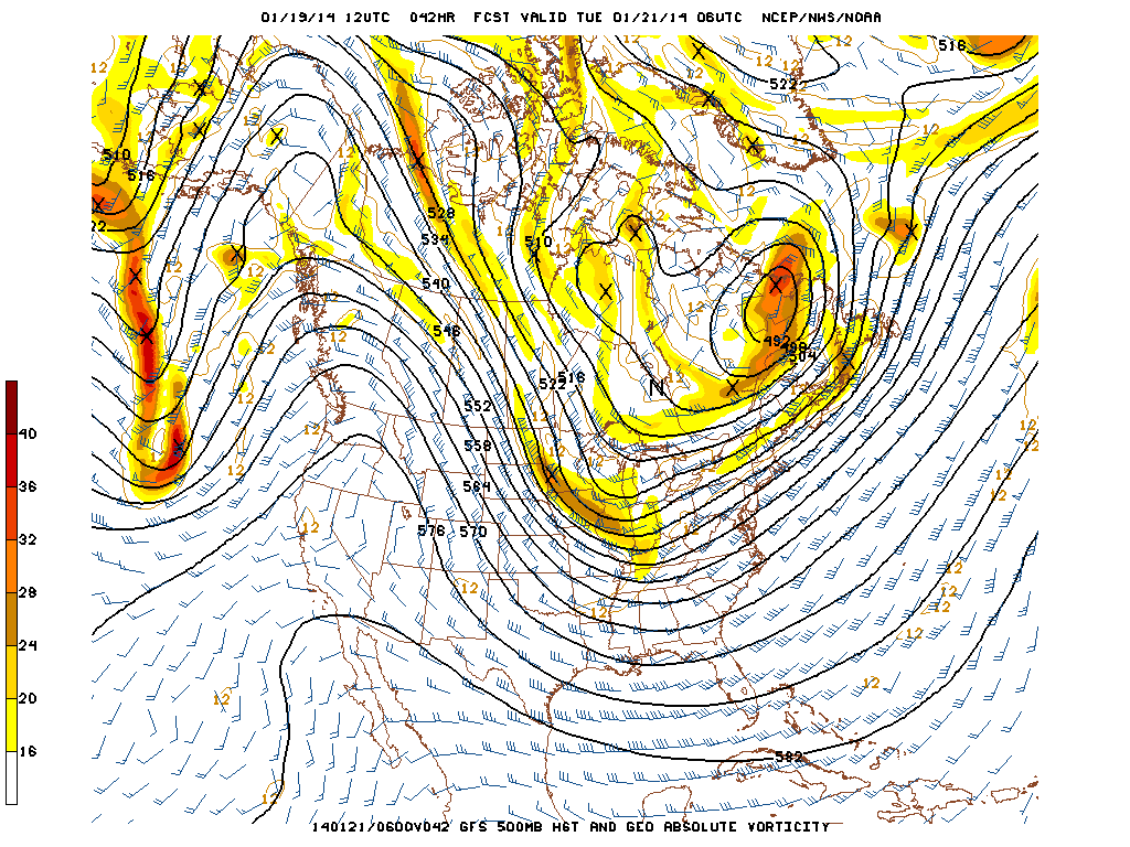
Today’s 12z GFS model shows some favorable, and some unfavorable factors for snow along the East Coast come Tuesday. (NCEP)

Above is today’s 12z GFS 500mb and vorticity forecast, valid for Monday night. We see a strong PNA ridge to the west, providing some amplitude to the pattern and supporting a trough in the East. It also helps to displace a big chunk of the Polar Vortex in SE Canada, further providing cold and supplying the trough in the East. As a result, a shortwave disturbance can be seen in the Plains and Midwest, as it is getting squeezed between the ridge and vortex, and is forced to amplify somewhat. This all sounds good for a snow event so far, but there are still several caveats.

Read more

Transition to colder, snowier pattern becoming likely

Forecast models in the medium to long range,continue to show a pattern change throughout the northern hemisphere — characterized by a west coast ridge and a large, anomalous trough in the Eastern United States. This has been mentioned several times over the last week as our forecasters have suggested the pattern change by the end of January. Exactly how the pattern plays out remains a mystery at this juncture, especially as some continue to overanalyze and interpret operational model guidance — which is never smart. The individual nuances of the pattern are going to take days to iron out.

The first development of note is that the ECMWF has finally caved to the GFS and GEFS interpretation of tropical forcing which will increase later this week and help the development of some major pattern changes. The ECMWF had previously been very stubborn in insisting against this development and keeping the impulse quite week. This cave is very important for the eventual changes in the Pacific including the development of a +PNA regime (i.e the west coast ridge).

MJO forecast from the ECMWF model.

MJO forecast from the ECMWF model.

Read more

Dense fog takes over NYC, in photos

The story of the morning, undoubtedly, was the development of dense fog which initially began in only patchy areas of the suburbs early this morning. But by sunrise the fog had lowered and thickened, in addition to spreading throughout the area — including into lower manhattan. The sunrise and aforementioned development of dense, low fog created a terrific (and somewhat rare) picture opportunity as the tops of building and bridges stuck out of the low cloud deck.

Often misunderstood, fog forms as water vapor condenses into tiny water droplets in the lower levels of the atmosphere. Fog is not water vapor itself (Water vapor cannot be seen), nor is it “smog”, a variation of the word which is used to describe lowered visibilities that occur as a result of pollution. But this morning was a more classic case of low fog, more typical in London or San Francisco. The occurrence was a terrific photo opportunity for some of New York City’s best photographers (and webcams). We’ve included some of the best shots below.

The National Weather Service continues a Dense Fog Advisory through noon today, and also urges caution for those who are traveling. Visibilities near zero are possible in some areas, and the fog is expected to cause delays not only on the roads but also at the area airports. The fog is expected to lift by this afternoon, with a chance of scattered showers and high temperatures generally in the mid to upper 40’s.

NYC in fog this morning. Image via Earthcam, twitter.

NYC in fog this morning. Image via Earthcam, twitter.

Read more

SPC set to add two new risk categories in 2014

The Storm Prediction Center has used the same risk categories for a large part of most of our meteorological careers. Although they have adjusted the probabilities, percentages, and yes even the colors — the categorical risk areas have remained the same. In Spring 2014, that will change. The Storm Prediction Center currently uses a simple categorical risk system which highlights the potential for severe thunderstorms across the country. The risk areas of Slight, Moderate and High are triggered by percentage chance of a type of severe weather within 25 miles of any point. And while the newer outlooks also highlight the potential for general non-severe thunderstorms across the country, Spring 2014 will mark a dramatic change in the outlooks.

The main change will be the addition of two risk levels, both falling on opposite sides of the “Slight” risk of severe thunderstorms. “Marginal”, a new risk category, will highlight the potential for severe thunderstorms that includes a 5-10″ chance of wind and hail and a 2-5% chance of tornadoes — but does not trigger a slight risk. “Enhanced” falls on the other side of “Slight”; in other words the risk levels are enhanced (30-45% risk) but not organized or widespread enough to trigger a Moderate Risk. Below, the Storm Prediction Center has released a new probability to categorical description table to help understand the changes.

The new SPC risk categories expected to be implemented in 2014.

The new SPC risk categories expected to be implemented in 2014.

Read more