Chances for cold and snow are significantly increasing to close the month

As we are currently in the midst of a January thaw, many people are looking ahead to find out when this thaw will end and when snow chances will begin. Some rumors had been spreading about a snowfall event on Wednesday/Thursday, and again around Saturday, but both of these threats appear unlikely to produce much in the way of snow. It is not until next week and beyond when we expect the pattern to become more favorable for snow.

Taking look at the threat, or lack-there-of, for Wednesday into Thursday, the main problems stem from a progressive pattern and one that is still in flux.

Today's 12z European model shows an unfavorable look for a snowstorm on Wednesday night with a very progressive pattern. Image credit goes to the WSI Model Lab.

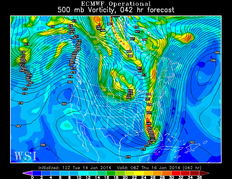
Today’s 12z European model shows an unfavorable look for a snowstorm on Wednesday night with a very progressive pattern. Image credit goes to the WSI Model Lab.

The above image is the 500mb pattern and vorticity that is forecast by the European model for Wednesday night. There is a large area of vorticity in the southeast states, but notice how it is very elongated and not consolidated. Also notice how there is another disturbance right on its heels in the Northern Plains and Midwest. This leads to shortwave ridging in the Ohio and Tennessee Valley, which penetrates the trough and forces it to be very narrow and progressive. Also working against the potential for a bigger system is the lack Atlantic blocking to help the pattern to buckle. Instead, the entire country has a NW to SE axis to the heights, instead of a more meridional north to south flow. Thus, there is no room for the trough to grow and amplify. So this disturbance slides out to sea, and does not impact the area. There may not be any precipitation at all in the Wednesday night into Thursday time period.

The same general theme holds true for the threat on Saturday.

Today's 12z European Model valid for Friday night shows a slightly improved pattern for snowfall, but still not one that ultimately supports a snow event. Image credit goes to the WSI Model Lab.

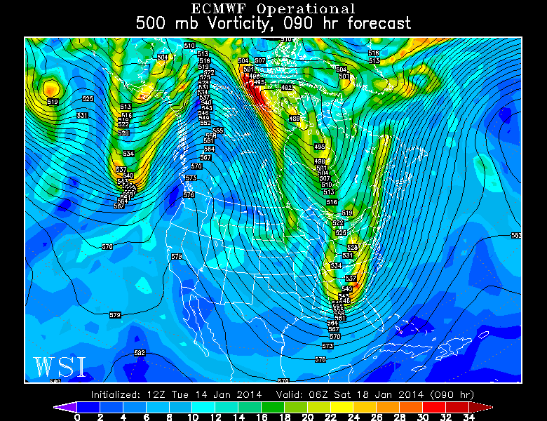
Today’s 12z European Model valid for Friday night shows a slightly improved pattern for snowfall, but still not one that ultimately supports a snow event. Image credit goes to the WSI Model Lab.

Moving forward to Friday night, we can notice a few important features. First of all, there is still a strong PNA ridge out west, which promotes a tough in the East, and could theoretically favor snowstorm chances. That being said, the Atlantic and Arctic blocking are still nowhere to be found, so the trough cannot buckle. It’s still a progressive pattern — one with a NW to SE height orientation throughout most of the country, which leaves no room for major trough amplification. We have a trough in the East, but once again, the vorticity is relatively disjointed and the trough is being pushed eastward. There is another disturbance right on its heels again in Minnesota, which forces weak shortwave ridging in Illinois, further preventing major amplification of any trough. By the time the trough is finally able to amplify and consolidate, it is already out to sea, with maybe a few passing snow showers. Eastern New England could potentially receive a couple of inches of snow, however.

Read more

Week begins with transient weather

It’s almost as if “roller coaster” has become an insufficient way to describe the pattern changes that our area has observed over the past several weeks. This past 5-7 day period was no different, as we transitioned from the Polar Vortex with sub-zero wind chills to a strong southerly flow and temperatures in the 60’s. After a cold frontal passage on Saturday evening, however, things have settled down a bit. Monday will end up relatively benign with temperatures slightly above average — and minimal precipitation.

The changes begin by late Monday, however, as increasingly thick clouds will begin to stream into the area from the southwest. A mid level disturbance approaching the area from the Mississippi Valley will be moving quickly off to the northeast, and minimal amplification is expected with no significant low pressure system. Nevertheless, unsettled weather with clouds and showers will grab the reigns of the forecast from Monday Night into Tuesday. Above normal temperatures will eventually be shunted east of the area once again as more wintry air moves in behind the system by midweek.

NAM model showing the development of widespread showers and clouds throughout the area late Monday Night into Tuesday.

NAM model showing the development of widespread showers and clouds throughout the area late Monday Night into Tuesday.

Read more

Cooler, drier weather behind cold front

Warm, humid air with showers and thunderstorms were the main characteristics of the airmass on Saturday — but a distinct cold front moved through the area later on Saturday evening and the airmass has changed dramatically since then. Winds shifted from southerly to west-northwesterly by late Saturday evening into Sunday morning, and temperatures in the mid levels will drop even more considerably Sunday morning. Although overnight temperatures won’ t be frigid (especially in comparison to what we were dealing with 5 days ago), highs on Sunday will only reach into the mid 40’s, considerably cooler than Saturday.

Fair weather will be the main weather story through early week, despite the potential for a few showers on Monday. Sunday looks quiet, with around average temperatures and a westerly breeze. With no precipitation or hazards expected, it will be a sufficient close to a weekend which had only featured unsettled and dreary conditions to this point.

NAM model forecasting high temperatures in the mid 40's on Sunday afternoon.

NAM model forecasting high temperatures in the mid 40’s on Sunday afternoon.

Read more

Heavy rain, strong winds, and potentially thunder highlight Saturday

The snow and freezing rain this morning has left the immediate area, and gave most areas a coating to 1″ of snow, and also very treacherous roads. Now that the warm front has passed the area, temperatures have risen above freezing, moisture has increased, and dense fog is beginning to develop. An extremely saturated low-level profile will continue to promote an increase in fog as the night goes on, so all motorists should be extremely careful when traveling tonight, as visibilities will be below 1/4 of a mile at times.

However, a freezing rain advisory still exists for interior Central and Northern NJ, interior southern NY, and interior southern CT, as cold air has still remained at the surface. Areas close to NYC should change over to plain rain by midnight with less than a tenth of an inch of ice, and areas a bit further inland may remain below freezing until 4:00am, as a tenth of an inch of freezing rain could fall. Travel especially carefully in these areas. For more information on these advisories, see the embedded links. 

Moving forward to tomorrow, the weather will continue to get worse. A storm system will be deepening and cutting into the Great Lakes, leaving a cold front in its wake — all the way down to the Gulf of Mexico.

Today's 18z NAM valid for tomorrow at 1:00pm shows a 988mb low in SE Canada with a cold front draped across the Appalachians.

Today’s 18z NAM valid for tomorrow at 1:00pm shows a 988mb low in SE Canada with a cold front draped across the Appalachians.

The NAM model shows the cold front quite well. East and southeast of the 988mb low in SE Canada, winds are generally southerly and southeasterly; whereas to the south, west, and southwest of that low, the winds are generally westerly and southwesterly. Additionally, a classic indicator of a cold front is a pressure trough. The isobars are the solid black lines. In the area where the different wind directions are converging, there is a very well-defined pressure trough in Ohio and Kentucky, further proving the location of the cold front. It perfectly matches the region where the wind is changing in direction.

Today's 18z NAM valid for 4:00pm tomorrow shows an area of very high precipitable water values streaming into the northern Mid Atlantic, an indicator of a significantly moist atmospheric column. This supports the potential for heavy downpours.

Today’s 18z NAM valid for 4:00pm tomorrow shows an area of very high precipitable water values streaming into the northern Mid Atlantic, an indicator of a significantly moist atmospheric column. This supports the potential for heavy downpours.

Although there is not a whole lot of cold air behind the front, the front is still powerful due to significant moisture differences, as well as an abundance of warm air and moisture out ahead of the front. The high preciptable water values shown above, as well as surface temperatures rising into the upper 50 and low 60s leads to low-density air that can easily be lifted. This warm and moist air being lifted by the cold front will help to trigger an area of heavy rain, and potentially enough convection to lead to a squall line with embedded thunderstorms.

Read more