Brutally cold weather set to grip the region

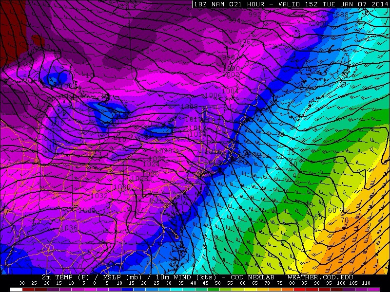
A wild swing in temperatures observed over the last 24-36 hours will end later on Monday as an arctic front approaches the region, and brings brutally cold air with it — for good. The past 24 hours or so have featured a dramatic roller-coaster of sorts in regards to temperature in the New York City region, beginning with overnight lows in the single digits to teens on Sunday. After a period of freezing rain, temperatures rose into the 40’s and 50’s overnight. Ahead of a cold front, warm and moist air streamed northward on Monday bringing temperatures into the upper 50’s with dense fog. Almost as if scripted, a thin line of thunderstorms surged eastward bringing heavy rain and gusty winds (51mph gust at Newark Airport) followed by a change in wind direction. Many NJ observers reported sleet on Monday afternoon as arctic air began seeping in behind the front. The 40-50 degree temperature swing in both directions will continue through Tuesday.

The National Weather Service has issued Wind Chill Advisories and Wind Advisories throughout a vast majority of the area beginning at 1am on Tuesday and continuing through the afternoon hours on Tuesday, as arctic air is expected to take over the airmass to a dramatic extent. Very low heights and extremely cold air aloft will bring high temperatures down into the single digits and teens on Tuesday, and when combined with strong and gusty westerly winds, will lead to wind chill values from 5 to 20 degrees below zero even during the afternoon hours. That type of cold air can prove dangerous, especially when prolonged exposure is involved. To prepare for the cold: wear layers, plan to be indoors as much as possible, and remember to pay close attention to your pets when they are outside.


20140106-152501.jpg

Read more

Mid January thaw a transient interruption in the pattern

The pattern over recent weeks has proven to be an interesting one across the majority of the United States, as the record cold temperatures and plentiful snow has visited folks from the Mid-west, Great Lakes, and the Northeast. Our significant snowstorm last week was due in large part to the negative EPO / positive PNA regime in concert with a well-timed Greenland block, allowing short wave amplification to occur on the mid atlantic coast. Since that time, the Greenland block has dissipated, and the western ridge will collapse in a few days, not before a near record / record cold airmass arrives Monday night.

(Log in to view this post, or purchase it for $.99 !)

[s2Member-PayPal-Button sp=”1″ ids=”4153″ exp=”72″ desc=”View this Premium Long Range Post for only $.99!” ps=”paypal” lc=”” cc=”USD” dg=”0″ ns=”1″ custom=”www.nymetroweather.com” ra=”0.99″ image=”default” output=”button” /]

Read more

Freezing rain, warmup prelude polar air intrusion

As crazy as it may currently sound, temperatures in the 40’s and 50’s are not far away. The teens and 20’s which settled into the area behind the significant snowstorm on Friday have essentially dominated the weekend, but an increasingly strong southerly flow will eventually push out the cold air in favor of warmer air surging northward. The cold air will be slow to scour out at the surface, however, which could create the potential for freezing rain across the interior.  Below, a forecast sounding from Northeast NJ shows the very cold air trapped at the surface — but warm air aloft. This kills the development of snowflakes, so precipitation falls as rain, but the rain can refreeze at the surface once it falls as temperatures remain a few degrees below the freezing mark of 32 F. By later Sunday into Sunday night, forecast models are in good agreement that precipitation will have changed to all rain across the forecast area.

The warmup will come to a crescendo on Monday morning and early afternoon, just ahead of an approaching cold front. A large and powerful system forming over the Central United States (more on that below) will drive extremely cold air into the Central and Eastern United states by Tuesday. But along and ahead of the front, increasing low level moisture and rising temperatures will be the cause for showers and temperatures into the 40’s to near 50 early on Monday. Behind the front, the coldest air in recent memory will begin surging into the area.

A forecast sounding from the NAM model in Northeast NJ on Sunday. Notice the cold air (below freezing) trapped near the surface while warm air dominates aloft.

A forecast sounding from the NAM model in Northeast NJ on Sunday. Notice the cold air (below freezing) trapped near the surface while warm air dominates aloft.

Read more

Snow lingers, but cold air becomes main story

After a significant winter storm blanketed the area overnight (snowfall totals and maps forthcoming later today once we gather more data), some snow still lingered across the area early this morning. The snow was falling mainly along the New Jersey shore and Long Island as a result of an inverted trough, or an area of lower pressure and forcing which extends away from the main low pressure system. In this case, the main surface low pressure is well east of our area, but the inverted trough extending westward towards the coast is allowing for some continued precipitation.

Filtered sun will give way to clearing by later this afternoon throughout much of the area as the storm system finally pulls away. But by tonight, cold air will become the dominant story. Forecast models are in good agreement on a very cold airmass and classic northerly winds settling into the area — but with the new snow pack,  temperatures could take a historic tumble. Forecast guidance is indicative of low temperatures dropping below 0 F during the overnight from Friday into Saturday, putting some low temperature records in jeopardy. The air will feel even colder due to the aforementioned winds, with wind chill values well below zero through the entire area.

NAM model forecasting low temperatures below zero through much of NJ and NYC tonight.

NAM model forecasting low temperatures below zero through much of NJ and NYC tonight.

Read more