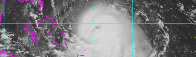
As it moved through the very warm ocean waters near the Bahamas on Thursday, Hurricane Joaquin strengthened further, reaching Category 4 status on Thursday afternoon. Maximum sustained winds reached 130 miles per hour. The National Hurricane Center suggests additional strengthening is possible, with maximum sustained winds approaching 140 miles per hour.
Computer models have continued their immense struggles with the track and intensity of Joaquin. A storm which was modeled by only a select few to become a major hurricane just days ago, has strengthened far beyond additional expectations. One of the major reasons for this is a farther south track — into warmer waters — which also was not anticipated by modeling until 36-48 hours ago when the ECMWF was the first to suggest a southward jog.
Hurricane Joaquin strengthened this morning, with maximum sustained winds of 80 miles per hour, in the Caribbean. The hurricane is expected to strengthen further over the next few days as it meanders in the Southwest Atlantic. Warm waters and minimal shear will continue to support storm organization. Thereafter, Joaquin is expected to make a turn northward, moving into the Southwest Atlantic Ocean. As it does so, an energetic disturbance over the Southeast States will race toward the storm. As the two phase, Joaquin is expected to accelerate and make a rapid turn west toward the Mid-Atlantic coast.
Exactly where the storm tracks, and how strong it is, remains highly uncertain at the present time. Forecast models are struggling with intricate details of the atmospheric setup. Unsurprisingly, small changes in the atmospheric interactions will have big changes on the eventual outcome and effects along the East Coast. The potential envelope of solutions remains extremely large — and so this post will attempt to explain the atmospheric setup, potential scenarios, and possible hazards in our area
https://www.nymetroweather.com/wp-content/uploads/2015/09/head1.png199682John Homenukhttps://www.nymetroweather.com/wp-content/uploads/2024/02/Empire-2000-x-300-px-2.pngJohn Homenuk2015-09-30 12:39:352015-09-30 12:39:35Joaquin likely to impact US East Coast, local impacts uncertain
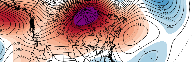
It has been a while since the meteorological community has had the chance to analyze the potential for higher latitude blocking. It has also been a while since we’ve had the opportunity to analyze a synoptic heavy rain event. Both of those look to come to fruition, in multiple facets, over the next five to seven days. A dramatic pattern change will unfold across North America this week, with anomalously strong ridging and surface high pressure building into Canada and the Northwestern Atlantic Ocean. Precariously timed with the formation of a tropical cyclone, this blocking high pressure will lead to a forecasting headache — and the potential for heavy rains and impacts from a Tropical Storm along the East Coast.
For those without a technical background, high latitude blocking is a broad term for higher then normal pressures/heights in the higher latitudes. These “blocking” ridges of high pressure to our north, sometimes over Canada and the Atlantic and sometimes as far north as parts of Greenland, slow down the weather pattern closer to our area. The slower weather pattern can allow disturbances to interact and phase — forming much larger, more powerful storms that otherwise would have continued on their own way if the pattern was moving at a normal progressive speed.
This week, forecast models are in agreement that higher latitude blocking will develop over much of Canada into the Northern Atlantic Ocean. Ridging builds into these areas in the mid levels of the atmosphere, and a very strong surface high pressure builds east and southeast into Canada and even parts of New England. This is one important piece to the forecast headache, and one reason why meteorologists are slightly more concerned than normal at this range: The tropical system, or storm system that forms, cannot simply escape north or northeast. The blocking will slow down the pattern considerably.
https://www.nymetroweather.com/wp-content/uploads/2015/09/Capture.png216662John Homenukhttps://www.nymetroweather.com/wp-content/uploads/2024/02/Empire-2000-x-300-px-2.pngJohn Homenuk2015-09-28 20:36:102015-09-28 20:36:10Tropical system, blocking will lead to forecasting headache
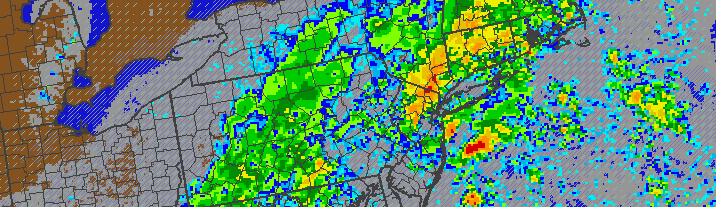
A stretch of pleasant weather over the past several weeks will finally come to an end, as tropical moisture and multiple coastal storm systems bring an increased likelihood of rain.
The pleasant weather, while welcomed, has brought upon Moderate Drought conditions throughout much of New Jersey and New York, with the Department of Environmental Protection recently issuing a Drought Watch. The rains this week will put a significant dent in the deficits we have built up since late-summer.
Forecast models are in good agreement that a frontal zone will sink toward the area on Tuesday, with enough forcing and lift for precipitation to develop. Making matters even more interesting, a southeasterly flow will aid in the expansion of tropical moisture along much of the East Coast. As all of this occurs, models suggest a low pressure system will develop near the front, aiding in heavier and more widespread rainfall on Wednesday.
Hi friends! Our website uses cookies to provide an optimal browsing experience for you. New "Cookie Consent" laws mandate us to inform you of this. As long as you're cool with it, just hit OK. You'll only see this message once.
We may request cookies to be set on your device. We use cookies to let us know when you visit our websites, how you interact with us, to enrich your user experience, and to customize your relationship with our website.
Click on the different category headings to find out more. You can also change some of your preferences. Note that blocking some types of cookies may impact your experience on our websites and the services we are able to offer.
Essential Website Cookies
These cookies are strictly necessary to provide you with services available through our website and to use some of its features.
Because these cookies are strictly necessary to deliver the website, refusing them will have impact how our site functions. You always can block or delete cookies by changing your browser settings and force blocking all cookies on this website. But this will always prompt you to accept/refuse cookies when revisiting our site.
We fully respect if you want to refuse cookies but to avoid asking you again and again kindly allow us to store a cookie for that. You are free to opt out any time or opt in for other cookies to get a better experience. If you refuse cookies we will remove all set cookies in our domain.
We provide you with a list of stored cookies on your computer in our domain so you can check what we stored. Due to security reasons we are not able to show or modify cookies from other domains. You can check these in your browser security settings.
Other external services
We also use different external services like Google Webfonts, Google Maps, and external Video providers. Since these providers may collect personal data like your IP address we allow you to block them here. Please be aware that this might heavily reduce the functionality and appearance of our site. Changes will take effect once you reload the page.
-2")