Monitoring the Stratosphere in November

Well, we’d be wrong not to mention that we are all rejuvenating from releasing our winter forecast for 2015-16. We hoped you all enjoyed reading it –whether or not it was what you were hoping to hear. It took a lot of collaboration, research, and efforts between all of us here to put it together.

In the upcoming days, we plan for a series of technical posts for our premium subscribers to explore more on important topics from the winter forecast. For this post,  we discuss more about Stratospheric Warming.

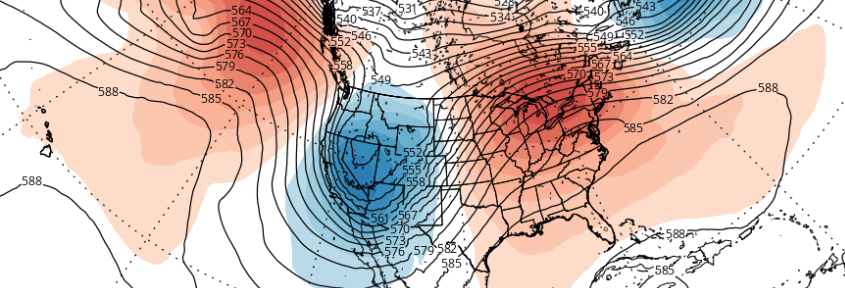
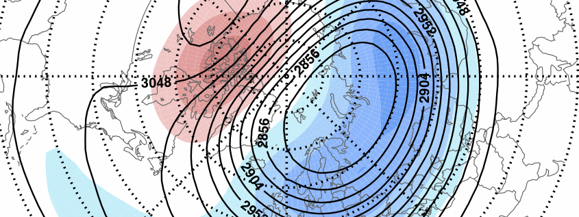
There’s been a high volume of discussion within the weather community regarding snow cover extent over Eurasia, and it’s potential foreshadowing of Sudden Stratospheric Warming (SSW) events, which may be correlated to a negative Artic Oscillation phase (-AO), 2 to 3 weeks thereafter.  According to the automated graph below, snow cover is now expanding and running close to 2009 at this time. As some of you may already know, the winter following that was featured colder than normal temperatures with above normal snowfall for December; and then same again in February. We also had a minor stratospheric warming in event in November, before a major SSW later in January and February.

Read more

Winter Forecast 2015-2016

You can view the entire 2015-2016 Winter Forecast in a PDF file by clicking here.

Primary Methodologies and Variables of Examination

  • El Nino Southern Oscillation (ENSO)
  • Arctic Oscillation (AO)
  • East Pacific Oscillation (EPO)
  • Pacific Decadal Oscillation (PDO)
  • North Atlantic Oscillation (NAO)
  • Siberian/Eurasian Snow cover and Stratospheric Warming
  • Solar Activity
  • Sea Surface Temperature Anomalies (SSTA)

Explanation of Variables

Over the past several months, our forecasters have monitored the above variables (plus others) and the trends in their behavior. We will be utilizing the above variables and indices, as well as their abbreviations, throughout the winter forecast. These variables reflect the atmospheric circulation patterns for certain geographical areas. For example, the AO refers to patterns within the Arctic Circle. The NAO refers to pattern characteristics in the North Atlantic, the PNA in the western part of North America, the PDO in the Pacific Ocean, and the EPO in the Northern and Eastern Pacific Ocean.

Typically, negative AO, NAO and EPO values correlate to enhanced high latitude blocking and high pressure to our north while lower pressure areas and troughs usually form underneath that high latitude ridging in the middle latitudes. In contrast, positive AO, NAO and EPO values generally yield lower pressure and less blocking to our north, while higher pressure and more ridging tends to build into the middle latitudes. There are exceptions to the rule, but generally the negative state of the above listed indices yields colder, more snowy weather in our area during the winter months.

Read more

November 2015 Outlook: Above Average Temperatures Likely

It’s that time of Autumn again, where weather enthusiasts start looking into the longer range forecasts for  telleconnections, pattern changes, and the first chance of snowfall; while everyone else who dreads winter will start shopping for new coats, boots and shovels. For now, it’s snow haters rejoice: It appears there will be very little wintry weather through most, if not all, of November.

Read more

PM Update: Cooler behind front, pleasant Halloween

Warm and moist air, which settled into the region on Wednesday Night, has been scoured out thanks to a cold frontal passage on Thursday afternoon. Sunny and warm conditions prevailed, thanks to lingering warm air near the surface, but temperatures in both the mid and low levels of the atmosphere will cool further overnight. Westerly winds took over for the southerly winds which had dominated beforehand, and will help to usher in the cooler airmass.

This trend will continue through Friday, with cooler air arriving throughout the Northeast United States. Highs will be several degrees colder than they were on Thursday. The air will feel crisp and, well, Autumn-like, with high temperatures topping out in the mid to upper 50’s with a westerly wind component.

Read more