A military aerostat (being commonly referred to as a blimp) tethered at a military facility in Maryland broke loose on Wednesday. The aircraft then floated over Pennsylvania, and was last spotted near Bloomsburg.
The craft detached from its moorings at Aberdeen Proving Ground around noon on Wednesday afternoon, and was immediately being tracked by authorities. But the blimp then started to drift north/northeastward into Pennsylvania. Authorities warned that “anyone who sees the aerostat is advised to contact 911 immediately”.
https://www.nymetroweather.com/wp-content/uploads/2015/10/blimp.png520800John Homenukhttps://www.nymetroweather.com/wp-content/uploads/2024/02/Empire-2000-x-300-px-2.pngJohn Homenuk2015-10-28 15:24:102015-10-28 15:39:52Military blimp detaches from tether, drifts over PA
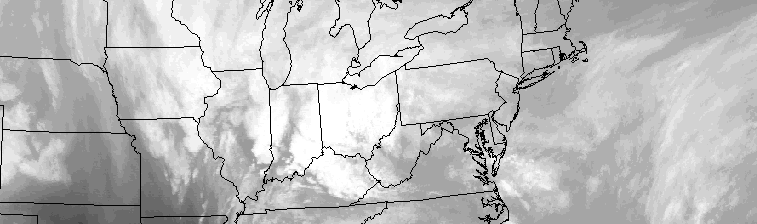
The interaction between tropical moisture — remnants of Hurricane Patricia — and a strong mid level atmospheric disturbance over the North Central US will aid in the development of steady rain on Wednesday. As forcing for precipitation increases during the morning hours, steady rains will develop from southwest to northeast throughout the area. Atmospheric moisture content will increase throughout the day, as a psuedo-warm front moves through New Jersey and New York.
Precipitable water values between 200 and 300 percent above average are a testament to the tropical moisture involved in Wednesday’s rains. During the late morning and afternoon, a low level jet stream is expected to strengthen, further aiding in the potential for heavy rains. While heavy rain isn’t expected to be constant, sporadic heavy rains could cause localized flooding, despite the moderate drought conditions in much of Northern New Jersey, New York and Connecticut.
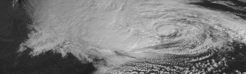
Nearly three years since Hurricane Sandy, many of her visual scars have faded. The memories of the storm, for many, have not. Meteorologically, Sandy remains just as incredible now as she was then — an unbelievable display of atmospheric power. One of the most fascinating aspects of Sandy was how strong she was, despite entering cooler waters. The meteorology behind her pressure is powerful and intricate, still, three years later.
Hurricanes have a strong warm core at the surface, weaken with height, and are barotropic — meaning there are no temperature or density gradients in their environment. This means that they are symmetric — their warm core is entirely surrounded by slightly cooler, but still abundantly warm air. The combination leads to hurricanes being vertically stacked (not tilted with height). Thus, hurricanes need warm water and weak upper-level winds in order to strengthen. Strong upper-level winds can choke a hurricane’s outflow channel, and advect in new airmasses of different temperatures — providing temperature gradients that hinder their development.
In further south latitudes, waters tend to be warmer, and the jet stream tends to be weak. As you head further north, however, the water becomes colder and the jet stream strengthens, leading to stronger upper-level winds. This helps to weaken a hurricane’s warm core at the surface, and tilt its vertically stacked structure, weakening the storm. However, as Sandy headed north, she was able to maintain category one hurricane strength with abnormally low pressures and eventually went on to cause widespread devastation. Why?
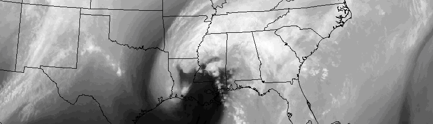
It has been quite some time since our area experienced an area-wide moderate rainfall event. That looks to change during the middle of this coming week, as the remnants of Hurricane Patricia interact with another atmospheric dsiturbance over the Central United States. The resulting low pressure system will develop through the Great Lakes and into Canada, allowing the northward surge of moisture along the East Coast and toward our area on Wednesday.
Interestingly enough, the indirect impacts from Patricia will be enough to bust a pattern which had been continuously dry in our area. Moderate drought conditions continued in much of Northern New Jersey, NYC, Long Island and Connecticut to start this week, still lingering from the very dry summer months. New York City is still running 8″ behind the average seasonal rainfall total. This weeks rainfall event, then, may be “welcomed”.
Hi friends! Our website uses cookies to provide an optimal browsing experience for you. New "Cookie Consent" laws mandate us to inform you of this. As long as you're cool with it, just hit OK. You'll only see this message once.
We may request cookies to be set on your device. We use cookies to let us know when you visit our websites, how you interact with us, to enrich your user experience, and to customize your relationship with our website.
Click on the different category headings to find out more. You can also change some of your preferences. Note that blocking some types of cookies may impact your experience on our websites and the services we are able to offer.
Essential Website Cookies
These cookies are strictly necessary to provide you with services available through our website and to use some of its features.
Because these cookies are strictly necessary to deliver the website, refusing them will have impact how our site functions. You always can block or delete cookies by changing your browser settings and force blocking all cookies on this website. But this will always prompt you to accept/refuse cookies when revisiting our site.
We fully respect if you want to refuse cookies but to avoid asking you again and again kindly allow us to store a cookie for that. You are free to opt out any time or opt in for other cookies to get a better experience. If you refuse cookies we will remove all set cookies in our domain.
We provide you with a list of stored cookies on your computer in our domain so you can check what we stored. Due to security reasons we are not able to show or modify cookies from other domains. You can check these in your browser security settings.
Other external services
We also use different external services like Google Webfonts, Google Maps, and external Video providers. Since these providers may collect personal data like your IP address we allow you to block them here. Please be aware that this might heavily reduce the functionality and appearance of our site. Changes will take effect once you reload the page.
-2")