(Premium) Long Range: Is the End of Winter in Sight?

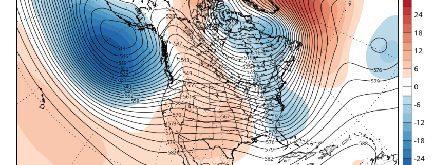
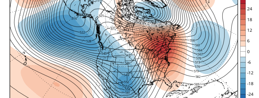
In the world of meteorology, Spring begins on March 1st. While the calendar doesn’t turn until the end of the month, meteorologists end winter statistics on the last day of February. Some winters, however, have featured major cold or snowstorms well into March and even April. Remember last year? Still, a year makes a big difference, as they say, and there are growing signs that after this week, cold and snow will become increasingly unlikely.

Looking back at February, temperatures will likely average above normal throughout the area. While we saw the first below zero temperatures in New York City in over two decades on Valentines Day, much of this month featured near or above average temperatures. Artic cold airmasses didn’t hang around for more than a few days. A couple of winter storms we saw earlier in the month tracked too far east to give the entire region of significant snowfall. And in the past two weeks, we have seen a storm track farther west with warmer air and heavy rainfall, as cold air moves in behind the storms.

Read more

(Premium) Will There Be An East Coast Snowstorm March 4th-5th?

After the midweek storm which is likely to be all rain, we are watching for the potential for storm system to develop near the Southeast US in the March 3-5 period.

Strong high pressure with much colder air will follow behind the midweek storm. Meanwhile, a shortwave will dig downstream off the West Coast ridge over the Rockies. This shortwave will become part of the southern stream and cause a low pressure storm system to develop over the Central or Southern Plains. Models indicate this storm will track towards Southeast or Lower Mid-Atlantic coast by Friday.

Read more

Warmer Temperatures Return Sunday and Early Next Week

Winter weather is with us through tonight, as temperatures remain quite cool. The good news? Some early spring-like weather is just around the corner, as temperatures will moderate and warm quite a bit on Sunday.

Mid-level height rises and deep southwest flow on Sunday, will help temperatures rise into at least middle to upper 50s with plenty of sunshine. It’s not out the question that some locations, particularly over Central New Jersey, will reach 60 degrees tomorrow afternoon. The southwest winds off the ocean or sound could keep temperatures cooler for parts of Long Island and Connecticut.

Read more

Heavy rainfall, thunderstorms, gusty winds possible tonight

A large deep low, which has been producing some severe weather and tornadoes over parts of Deep South over past few days, will be heading northward into Eastern Ohio Valley today. This storm will send a cold front northward through the Mid-Atlantic region this afternoon and evening.

Ahead of this front, positive vorticity advection, strong jet streak forcing and instability will be increasing. A convective or forced squall line is likely to develop over Central Pennsylvania southward into Virgina, with torrential downpours and gusty winds  near the low. Further south there is potential for more severe weather and tornadoes with greater instability. The Storm Prediction Center has issued large area of enhanced and moderate risks for parts of Virgina North Carolina, with slight and marginal risks further up and down the East Coast.

Read more