Thursday Overview: Watching Hermine for Labor Day Weekend

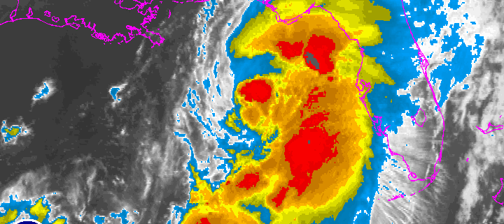
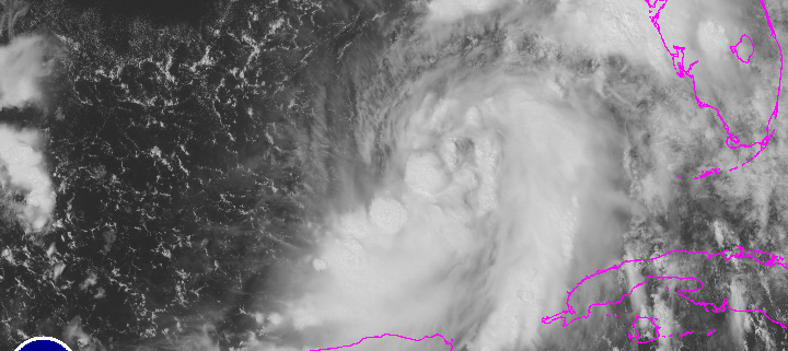
A wave of tropical moisture surging ahead of a cold front approaching the region, has led to periods of rain this morning. This is now beginning to taper off from west to east across the region. Clouds could break for some sunshine this afternoon. But there is still a chance of some isolated showers and thunderstorm popping up until the cold front moves through region late this afternoon. Temperatures will likely reach the upper 70s to lower 80s with enough sunshine this afternoon. Then tonight, skies will clear with high pressure building over the region. Friday will be mostly sunny with temperatures rising into upper 70s to lower 80s. Dry conditions will likely continue into Friday night. Then attention turns to Tropical Storm Hermine which is currently strengthening in the Gulf of Mexico and is forecast to make landfall as a minimal hurricane over the Florida panhandle late tonight.

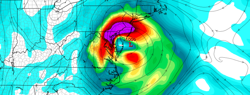
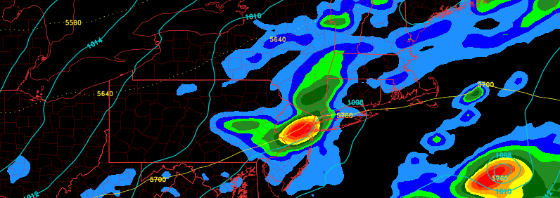
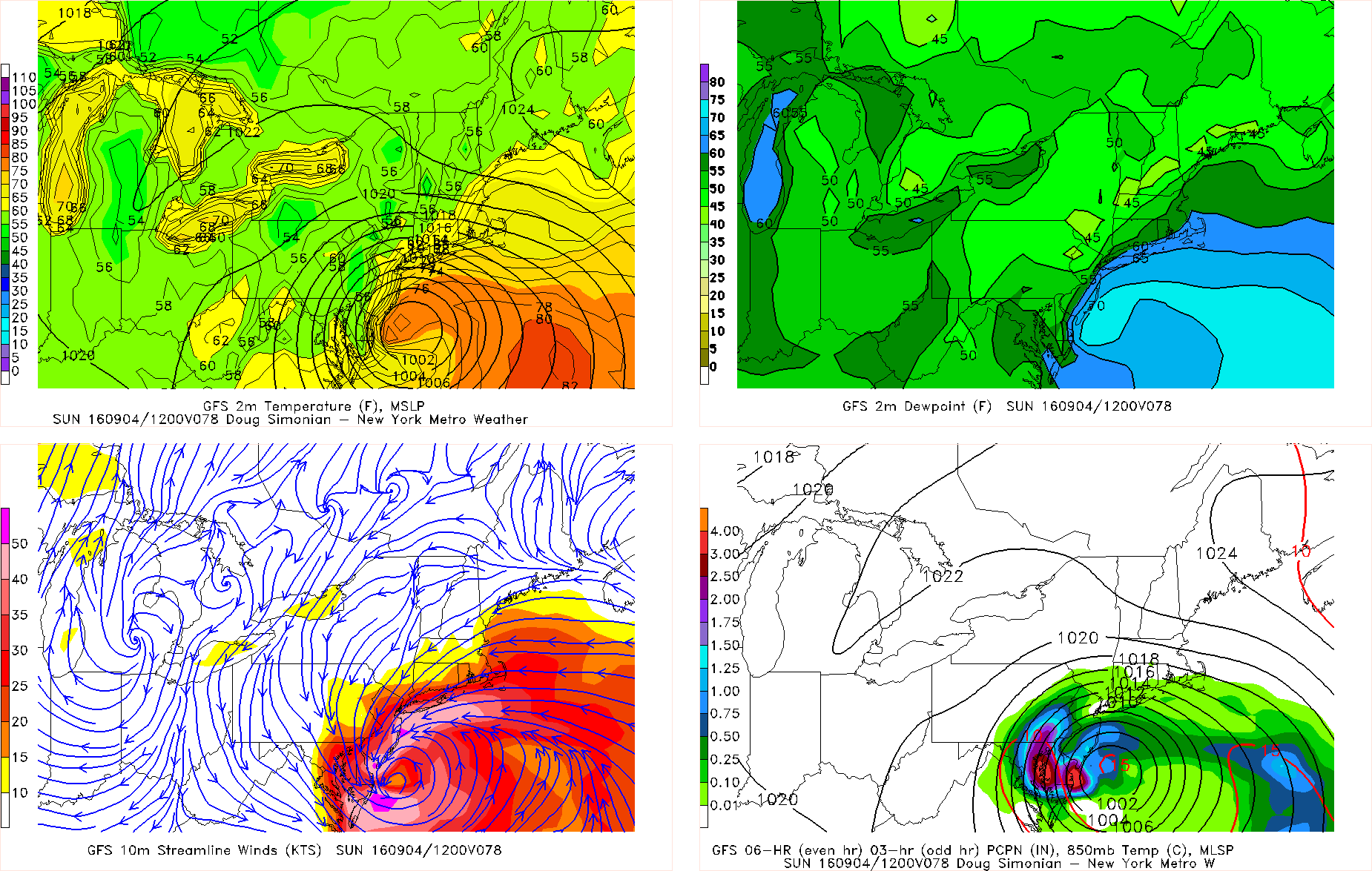
Much of the latest model guidance overnight has shifted further south and east with what remains of Hermine, reducing some impacts from heavy rain and high winds in parts of the area. However, models have not been too consistent with the track of this storm near our region, over the last few days. One of these models (the GFS) has also shifted west again during its early morning run, with heavy rainfall and strong winds for the New Jersey coast. The mid-morning and early-afternoon model runs have also shifted back northwest, bringing significant impacts back to the region. If Hermine tracks closer to region, the mostly likely time frame for significant impacts, appears to be on Saturday night and Sunday. .

Read more

What to know about Hermine and how it may affect the Northeast

Tropical Storm Hermine formed earlier today in the Central Gulf of Mexico, after several days of being tracked and obsessively monitored by meteorologists and weather hobbyists alike. Regardless, the storm has strengthened over the last 24 hours and is expected to continue to do so as it moves northeastward towards the Florida Peninsula. Thereafter, forecast models have taken a dramatic turn in their handling of the storm system.

Current forecast model guidance and ensemble data suggests that Hermine, after making landfall along the Florida Peninsula, will track northeastward along the Southeast Coast before re-emerging off the Mid Atlantic shoreline. As this occurs, the storm will begin to interact with an upper level system which is forecast to drop southward through the Ohio Valley and Mid Atlantic States. This interaction may pull Hermine westward back towards the Mid Atlantic and/or Northeast US coasts by late this weekend into Labor Day.

Read more

(Premium) Tropical Storm Hermine Increasingly Likely to Affect our Region

We continue to carefully monitor developments with tropical storm Hermine currently over the Gulf of Mexico. It is forecast to make landfall near around the Florida Big Bend area, as a tropical storm. But it could intensity more — into a Category 1 Hurricane — before making landfall. Therefore, a hurricane watch has also been issued for this region. The main threat will still be heavy rainfall and perhaps some coastal flooding and storm surge along the coast, due to the new moon cycle.

For our region, we watch for at least the remnants of this system to affect our area. Model guidance has been indicating that a northern stream shortwave will break off the upper-level trough that will passing through the Northeast tonight and tomorrow. This will trail the that trough and create a new, powerful shortwave trough in the Ohio Valley — similar to what we sometimes see during our strongest snowstorms. Then this shortwave trough and energy will amplify the downstream pattern, and thus interact with the shortwave energy from Tropical Storm Hermine, as it moves up somewhere near the Georgia and Carolina coasts on Friday.

Read more

Tuesday Overview: Nice Today, Showers/T-storms Possible by Wednesday night

Today is shaping up to be beautiful day with plenty of sunshine for most of the region. Temperatures this afternoon will warm into the middle 80s with humidity remaining comfortable. Some sea-breezes later this afternoon may keep areas near the shore a little cooler. Tonight, humidity will start to increase with light winds becoming more southeasterly. Clouds will also increase later tonight, which will keep temperatures from dropping as much as last night.

More southwest flow tomorrow, will cause humidity to increase. More clouds will be likely be around tomorrow, with a cold front and upper-level trough approaching from the west. If there is still enough sunshine, temperatures will likely reach the upper 80s to around 90, away from the shore.  Some isolated or widely scattered showers and thunderstorms are possible during the afternoon or evening. But are more likely later tomorrow night and into Thursday morning, with more tropical moisture coming northward along the front. Some heavy downpours are possible. Clearing will begin taking later Thursday afternoon as front moves east of region. Some other highlights for next several days.

Read more