Weekend Overview: Very Warm and Dry Weather Through Sunday

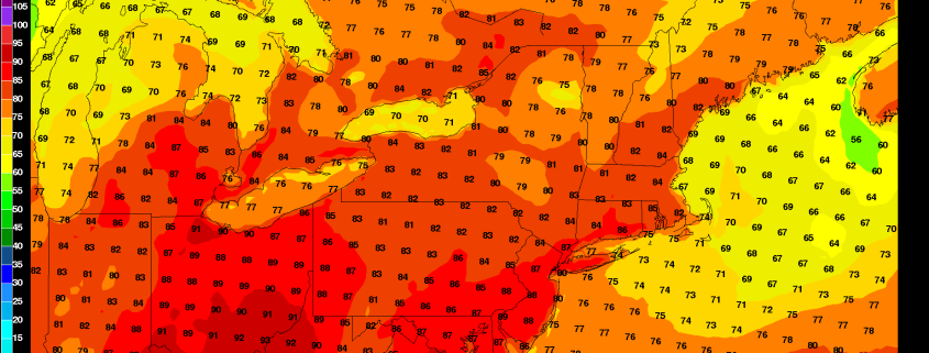
Beautiful, summery weather is store for this weekend with high pressure north and east of region in control.  Today will have plenty of sunshine with temperatures rising into upper 80s  around 90 this afternoon, especially inland. Light easterly winds may keep some areas near the shore a little cooler in the lower to middle 80s. These temperatures, are still several degrees warmer than average for this time year. But humidity will be more comfortable. Skies will remain mostly clear tonight with temperatures dropping into lower 70s over NYC metro and down into 60s in suburbs overnight.

Sunday will be mostly sunny again with high temperatures likely in middle to upper 80s, at least over inland sections. However, with high pressure further shifting northeast of the region, this will cause more southeast winds and sea-breezes to develop during the afternoon, especially over parts of Long Island and other south-facing shore. Which may see high temperatures only in the lower to middle 80s tomorrow. Which is still slightly above average. Some other highlights for the next few days:

Read more

The relentless ridge and its effect on 99L

When meteorologists looked at the medium range forecasts on the first of August, one thing was clear, it appeared: Troughiness would become more likely east of the Mississippi River by the tail end of the month. Brought on by a change in tropical forcing and an overall adjustment in the hemispheric wave pattern, this seemed like a moderate to high confidence forecast. Those ideas were wrong.

Instead, poor modeling and a changed pattern evolution has led to an entirely different outcome: The mid level ridging, which has become a staple of the East Coast weather pattern since early July, will return. Forecast model guidance has altered the hemispheric pattern evolution to support a -PNA (Pacific North American oscillation), or troughiness on the West Coast of the United States. This will only feed the development of a strong ridge from the Southeast United States into the Mid Atlantic.

Read more

Surge of cooler air likely to begin the week

A strong cold front, with an impressive thermal gradient, will push from the Ohio Valley through the Northeast late on Sunday evening. This cold front is associated with a larger mid and upper level system, which features an organized and deep trough emanating from Canada. The cooler air associated with this trough will be most prevalent in the Plains and Mississippi River Valley, but will also be noticeable in our area for a day or two behind the front.

This will be most recognizable on Monday and Tuesday, as atmospheric temperatures significantly cooler than the past several weeks settle overhead. Daytime highs will be cooler — and dew points will be much lower. Overnight lows may fall into the 50’s in the interior and 60’s even in the city and near the coast.

Read more

Weekend Overview: Warmth, scattered storm chances return

Worry not! When we say “warmth” we don’t mean the oppressive heat from last weekend. Instead, what will return this weekend are temperatures more typical of late summer. Highs in the upper 80’s will be commonplace throughout the area this weekend, especially away from the area shores. Showers and thunderstorms are possible on each day, most likely during the afternoon and evening, but aren’t expected to be severe. They’ll remain isolated to scattered throughout the area.

Winds will turn southeasterly by Saturday afternoon and evening, meaning the influence of the area waters will be felt a bit more near the beaches. A bit more of a breeze and cooler temperatures are likely near the coast on both Saturday and Sunday. This southeast flow comes ahead of a cold front, which is expected to bring a period of steady rain on Sunday Night. Here are your weekend weather highlights:

Read more