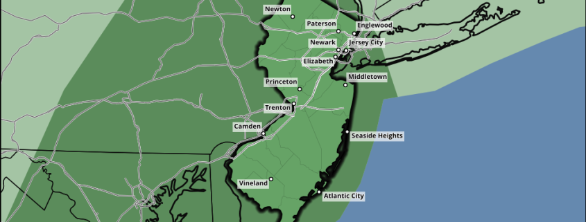
Coastal storm may bring heavy rain, wind on Saturday

Amazingly, we’re still talking about coastal storms during the middle weeks of May. A period long discussed as one that may favor a cutoff low or coastal storm seems to be coming to fruition, as forecast models have keyed in on a potential storm this weekend. Energy over the Ohio Valley will move eastward toward the Mid Atlantic, as additional shortwave energy drops southeastward from Canada toward the Mid Atlantic as well.

The resulting interaction will result in the development of a coastal storm, with a low pressure at the surface moving eastward towards the Mid Atlantic coast. But the exact track and intensity of the storm system will depend on the evolution in the mid and upper levels of the atmosphere. As the two pieces of energy interact and potentially phase, the surface low pressure will deepen — resulting in areas of heavy rain and strong winds developing to the north and northwest of the low pressure center.

Read more

Premium Weekly Outlook 5/16 – 5/22: Moderation to around average temperatures late week

After some cooler temperatures today and then some more unsettled weather for Tuesday and Wednesday, moderating temperatures to near normal with pleasant weather returns late this week. But there is a potential fly in the ointment for a warming trend to continue this weekend as a coastal storm may try to develop. For this weekly outlook, we’ll discuss some technical details and thoughts on the weather through this week and this coming weekend.

After a very chilly start with temperatures near record lows across the region, temperatures today should be a little warmer than Sunday’s high temperatures with slightly warmer mid-level temperatures, deep mixing and more sunshine in the afternoon. High temperatures should rise into the lower to middle 60s for much of the region today. A tight pressure gradient and winds around 40kts on top of a deep mixed layer will also cause west-northwest winds to gust between 30mph and 40mph again today. The west-northwest winds will also keep sea-breezes from developing this afternoon for coastal locations.

Read more

Premium: Tropical forcing likely to support warmer late May pattern

Cooler temperatures are on their way tomorrow and early next week with a large anomalous upper-level low moving over the Northeast. Some waves along a stalled frontal boundary may also affect the weather during the middle of next week. But we are still anticipating warmer temperatures in late May.  We have already discussed a number of reasons why we believe more warmth is on the way. But a major influence in this pattern shift will likely be tropical forcing from an active MJO event occurring over the Indian Ocean now.

First, the ensembles guidance still show the AO/NAO turning positive with more troughiness over Greenland/Davis Strait. This will not support as much troughiness, nor an upper-level low over the Northeast or Southeast Canada. Also a -PNA pattern will be developing with troughiness digging over the Southwest US. This will causes heights to build over much of the Central and Eastern United States.

Read more

Sunshine then strong t-storms with gusty winds possible by this evening

Mostly sunny skies will continue into early this afternoon, before  some clouds increase ahead of an approaching cold front and upper-level trough later today. Enough lift and ascent  will likely result in some showers and thunderstorms late this afternoon or this evening. High temperatures will reach the lower to middle 70s away from the coast by early this afternoon. Over Long Island and Connecticut coastal southerly winds will keep high temperatures in the middle to upper 60s.

Read more