Today will be another very warm and humid summery day for the Northeast with more widely scattered showers and thunderstorms popping up this afternoon and evening. Due to the stronger mid-level ridging, very weak wind fields and less instability with warmer mid-level temperatures, these storms will likely be less intense and fewer and father in between than on Wednesday. But will still be very slow-moving and capable of producing some heavy rainfall and flash flooding in some spots.
However, a shortwave energy embedded in a larger upper-level trough will be amplifying over the Great Lakes Friday and Saturday. This will cause low pressure to deepen and track northeast through the Great Lakes into Southeast Canada on Friday and Saturday. As it does so, it will drag a frontal boundary will be moving be slowly through the region, as ridging from the Western Atlantic gradually breaks down. Large scale ascent and lowering heights will support more numerous showers and thunderstorms over the Interior Northeast again.
https://www.nymetroweather.com/wp-content/uploads/2017/08/ne_f48.png8101260Miguel Pierrehttps://www.nymetroweather.com/wp-content/uploads/2024/02/Empire-2000-x-300-px-2.pngMiguel Pierre2017-08-03 10:11:002017-08-03 10:11:47Premium: Severe Weather Threat for the Interior Northeast Friday into Saturday
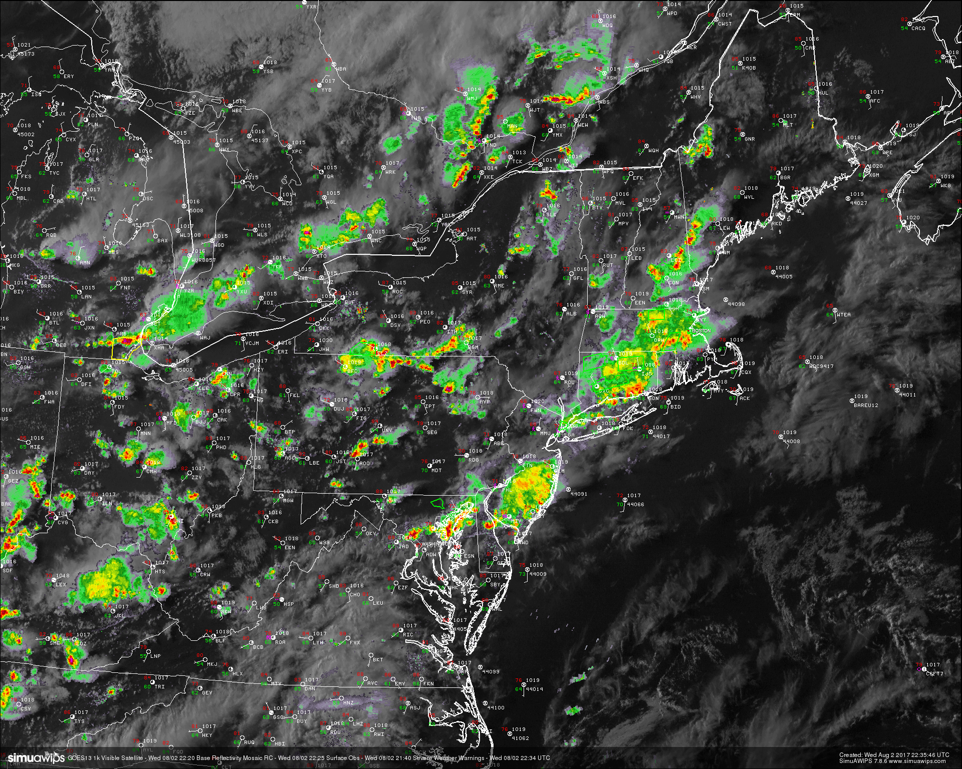
After a relatively hot and humid day across the entire Northeast and Mid Atlantic regions, we have seen large-scale thunderstorm development courtesy of the mid level shortwave that we discussed back on Monday. This shortwave was located to the west of the area, and with CAPE values of around 2000-3000 j/kg^2, PWATS near 1.5″, and strong low level lapse rates, the weak amount of energy associated with the disturbance was more than enough to set off numerous showers and thunderstorms around 2pm. Due to a significant lack of vertical wind shear, these storms were not able to move all that much from where the initial updrafts formed, and thus most cells rained themselves out over time. However, when these updrafts collapsed and the rain cooled air rapidly sunk to the surface, it created new boundaries which served to provide breeding grounds for renewed storm development. In some locations we saw this happen three to even four times over, which caused serious street flooding.
As of six o’clock this evening, most of the showers and thunderstorms that formed early this afternoon were finally beginning to wind down. Lightning activity over the area has greatly weakened over the past hour or so, and this also points towards a gradual dissipation of the rest of the thunderstorm activity. As this time, we think that the heaviest showers and thunderstorms should dissipate by sundown, with only a few lonely cells remaining thereafter. Some residual cloud cover is likely as we head into the overnight hours, and this will help to keep overnight lows rather mild, with temperatures dropping to around the low to middle 60’s.
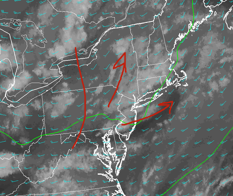
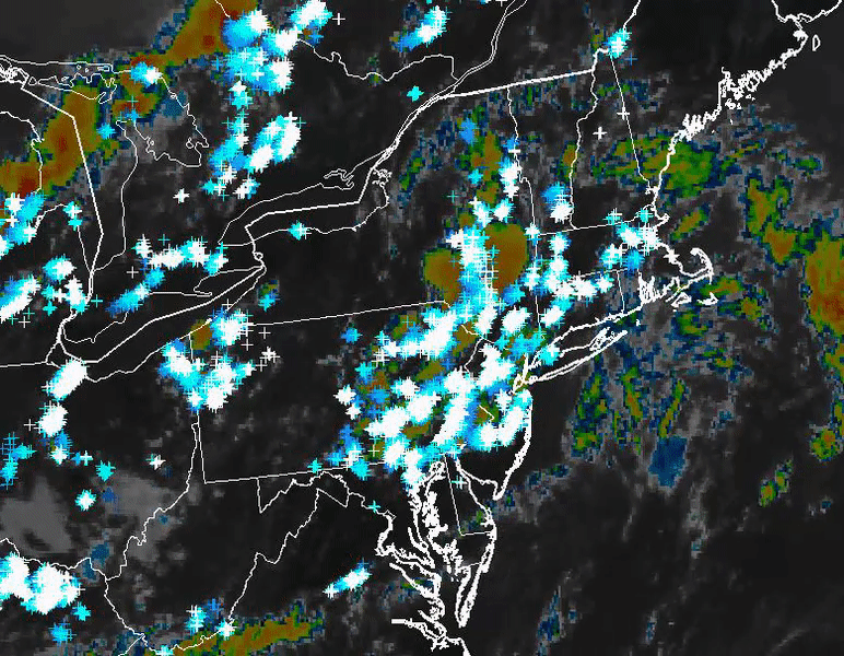
This evenings latest regional radar. high resolution visible satellite, surface observations. and severe warnings, showing the bulk of the heavy rain dying off. This trend should continue as we head deeper into the evening (Courtesy of Simuawips)
Thursday and Beyond
Thursday should start off just as the past few days have, with any low clouds quickly burning off by the mid to late afternoon hours. This will allow afternoon temperatures to climb significantly during the afternoon hours, with highs likely reaching the middle 80’s to lower 90’s across the area. With a moist airmass in place tomorrow, we should see the region destabilize once again by the mid to late afternoon hours, similar to as we saw today. The main difference will be that tomorrow does not look to have a coherent area of forcing to initiate thunderstorm development, so any thunderstorms tomorrow afternoon will likely have to rely on convergent boundaries from local sea breezes. This activity will likely be limited to a heavy rain and lightning threat given the lack of favorable parameters for anything outside of heavy thunderstorms. Storms should gradually fade tomorrow evening, leaving generally mild and humid conditions in their wake.
As we head into the first half of the weekend, a large shortwave trough diving out of Canada will provide a threat of heavy rain and possibly some thunderstorms over the area as moisture begins to surge north from the Gulf States. This system will be watched closely, as it does have a very favorable upper level jet streak which could potentially enhance a heavy rainfall threat over our area. A strong cold front looks to push through late Saturday and into Sunday, which should bring not only cooler temperatures to our area, but also much lower humidity compared to what we’ve been seeing-which should make for an enjoyable end to the weekend!
Now here’s a sample of what our Premium clients get with a special video discussion with Doug Simonian!
(Detailed Discussion With Doug Simonian)
For more information and posts like this one, make sure you sign up for Premium Forecasts — where multiple detailed articles, videos, and interactives are posted each day. Also, come interact with our staff and many other weather enthusiasts at 33andrain.com!
Have a great evening!
Steve Copertino & Doug Simonian
https://www.nymetroweather.com/wp-content/uploads/2017/08/header.png8351513Steven Copertinohttps://www.nymetroweather.com/wp-content/uploads/2024/02/Empire-2000-x-300-px-2.pngSteven Copertino2017-08-02 19:18:422017-08-02 19:18:42PM Rain Exits, Storms and Cooler Weather Possible This Weekend!
Good morning! More summer-like weather with more heat and humidity will continue for the rest of the week,with some scattered showers and thunderstorms possible each afternoon or evening. But it appears the Western Hemispheric pattern will undergo another more significant changes to support some cooler weather again for next week.
First changes, will start occurring over North Pacific as usual this week. An upper-level low will be near the Aleutian Islands or Southwest Alaska. This will cause a high-amplitude ridge to build over the West Coast by early next week. This will result in a larger trough digging and encompassing much of the Central and Eastern US over for next week. Then cooler airmasses from Canada will be invading the CONUS, with temperatures well below over the much of the Northern and Central Plains and into parts of Great Lakes and Ohio Valley.
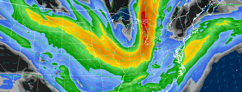
https://www.nymetroweather.com/wp-content/uploads/2017/08/gfs-ens_T2maMean_us_6.png6961024Miguel Pierrehttps://www.nymetroweather.com/wp-content/uploads/2024/02/Empire-2000-x-300-px-2.pngMiguel Pierre2017-08-02 09:00:582017-08-02 09:01:43Premium Long Range: Cooler, Active Pattern Next Week…More Changes Late Month?
Good evening! We hope you enjoyed this summery Tuesday. This article is going to just focus on the potential for thunderstorms on Wednesday afternoon — some of which could briefly pulse to strong to even severe status.
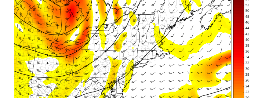
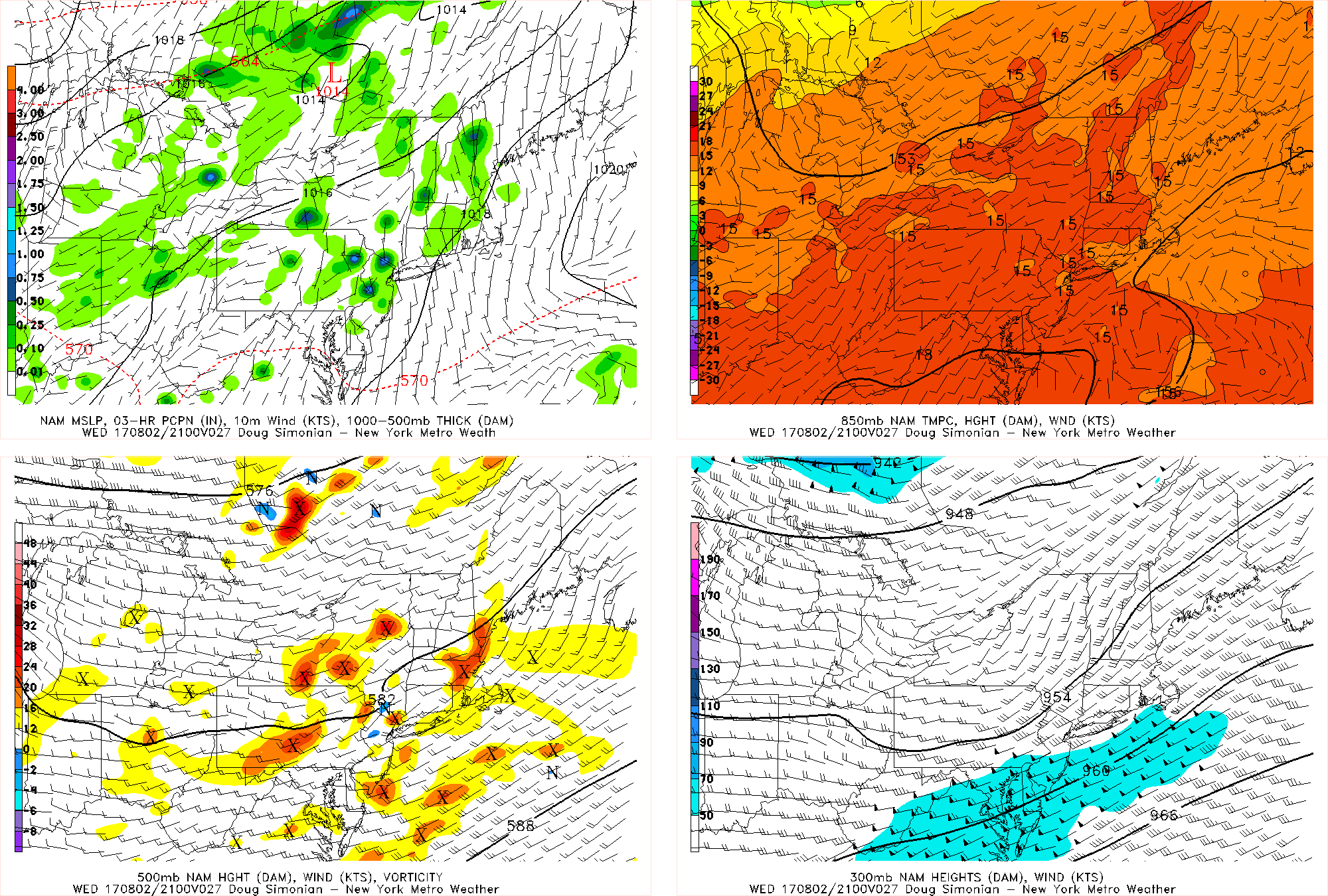
It all starts with a shortwave trough that will be moving into the area on Wednesday, bringing plenty of vorticity with it and thus lift. This is a true lifting mechanism that we have not had over the past couple of days, which should allow coverage of thunderstorms to be higher on Wednesday than on Monday and Tuesday.
Tuesday afternoon’s NAM model valid for Tuesday afternoon shows a shortwave trough with embedded vorticity helping to trigger some showers and thunderstorms in New Jersey.
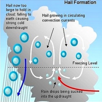
In the midst of this warm and humid airmass, surface-based instability should be pretty high already, but the fact that this shortwave trough will be lowering heights a bit but also not contaminating the airmass with too much moisture will help increase lapse rates somewhat significantly. This allows for updrafts to potentially be more robust and for more of the cumulonimbus cloud to be in dense, cold air aloft — both factors allow for more hail formation, the potential for downburst gusty winds, and somewhat vivid lightning.
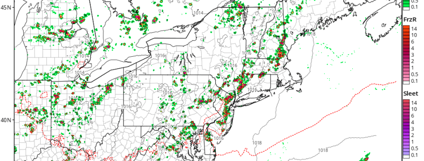
https://www.nymetroweather.com/wp-content/uploads/2017/08/nam3km_mslp_pcpn_frzn_neus_26.png7721024Doug Simonianhttps://www.nymetroweather.com/wp-content/uploads/2024/02/Empire-2000-x-300-px-2.pngDoug Simonian2017-08-01 19:32:272017-08-01 19:32:27Locally Strong Thunderstorms Possible on Wednesday
Hi friends! Our website uses cookies to provide an optimal browsing experience for you. New "Cookie Consent" laws mandate us to inform you of this. As long as you're cool with it, just hit OK. You'll only see this message once.
We may request cookies to be set on your device. We use cookies to let us know when you visit our websites, how you interact with us, to enrich your user experience, and to customize your relationship with our website.
Click on the different category headings to find out more. You can also change some of your preferences. Note that blocking some types of cookies may impact your experience on our websites and the services we are able to offer.
Essential Website Cookies
These cookies are strictly necessary to provide you with services available through our website and to use some of its features.
Because these cookies are strictly necessary to deliver the website, refusing them will have impact how our site functions. You always can block or delete cookies by changing your browser settings and force blocking all cookies on this website. But this will always prompt you to accept/refuse cookies when revisiting our site.
We fully respect if you want to refuse cookies but to avoid asking you again and again kindly allow us to store a cookie for that. You are free to opt out any time or opt in for other cookies to get a better experience. If you refuse cookies we will remove all set cookies in our domain.
We provide you with a list of stored cookies on your computer in our domain so you can check what we stored. Due to security reasons we are not able to show or modify cookies from other domains. You can check these in your browser security settings.
Other external services
We also use different external services like Google Webfonts, Google Maps, and external Video providers. Since these providers may collect personal data like your IP address we allow you to block them here. Please be aware that this might heavily reduce the functionality and appearance of our site. Changes will take effect once you reload the page.
-2")