Good afternoon! This afternoon will continue to be feature more pleasant weather. Sunshine will be mixed with clouds over parts of the region and winds will remain light out northwest. High temperatures should reach the upper 50s to lower 60s.
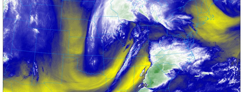
https://www.nymetroweather.com/wp-content/uploads/2017/04/WaterVapor.jpg9001600Miguel Pierrehttps://www.nymetroweather.com/wp-content/uploads/2024/02/Empire-2000-x-300-px-2.pngMiguel Pierre2017-04-05 14:00:542017-04-05 13:18:33FREE Public Analysis: Large Storm to Bring Heavy Rainfall Thursday
Happy Wednesday! Today will feature more pleasant weather with more sunshine and seasonable temperatures this afternoon. But another, larger storm system we’ve been talking about this week, will be bring more heavy rainfall tomorrow.
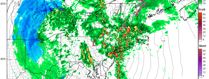
https://www.nymetroweather.com/wp-content/uploads/2017/04/nam3km_ref_frzn_neus_31.png7721024Miguel Pierrehttps://www.nymetroweather.com/wp-content/uploads/2024/02/Empire-2000-x-300-px-2.pngMiguel Pierre2017-04-05 11:26:352017-04-05 11:26:354/05 Late AM All Zones Update: Heavy Rainfall, Flooding, T-Storm Potential Thursday
Happy Tuesday! Heavy rains from overnight have moved out most of the region quickly this morning, as best forcing with a strong low-level has shifted northeast into New England. Thus flood watches for New Jersey and Lower Hudson Valley have been cancelled, with more significant flooding no longer anticipated for today. It will remain mostly cloudy with some showers, drizzle or patchy fog the rest of morning, as a the warm front remains to the south.
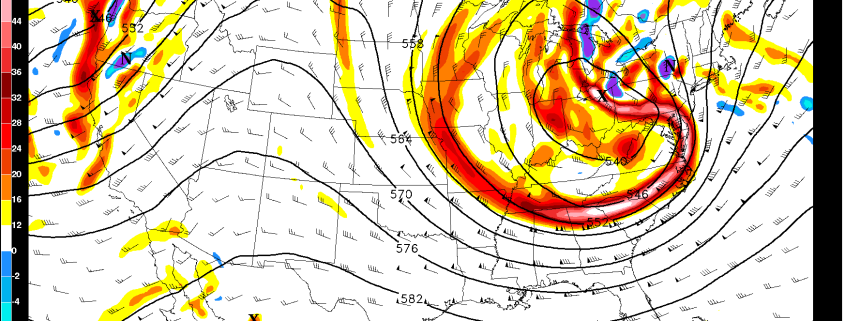
https://www.nymetroweather.com/wp-content/uploads/2017/04/GFS500mbvorticity60hr.png11241746Miguel Pierrehttps://www.nymetroweather.com/wp-content/uploads/2024/02/Empire-2000-x-300-px-2.pngMiguel Pierre2017-04-04 09:26:052017-04-04 09:26:054/04 All Zones AM Update: Strong T-Storms Possible This Afternoon, Larger Storm Likely Thursday
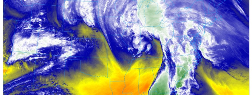
We hope you all enjoyed this lovely Monday! This nice weather will be very short-lived as a strong storm system is approaching and clouds will rapidly increase this evening, if they had not done so already. Heavy rain with this storm is likely after midnight tonight and into Tuesday morning, with perhaps a lull in the action followed by scattered thunderstorms in the afternoon.
This is the same storm that has brought tornadoes to the Southeast US and it has an extremely impressive moisture feed from the Gulf of Mexico and Caribbean. The core of the storm will be moving into the Central US and into the Great Lakes, but our placement well out ahead of the storm considering its expansive moisture feed actually places us in the area for heaviest rainfall. This is because the east side of these systems have the strongest wind fields; and in this case the strongest low-level jet for further moisture transport. Additionally, lift will be fueled by a warm front that will be pushing into our region ahead of the storm as well.
https://www.nymetroweather.com/wp-content/uploads/2017/04/10.jpg9001600Doug Simonianhttps://www.nymetroweather.com/wp-content/uploads/2024/02/Empire-2000-x-300-px-2.pngDoug Simonian2017-04-03 20:43:232018-05-01 12:56:39PM Zones Update: Heavy Rain and Embedded Thunderstorms on Tuesday
Hi friends! Our website uses cookies to provide an optimal browsing experience for you. New "Cookie Consent" laws mandate us to inform you of this. As long as you're cool with it, just hit OK. You'll only see this message once.
We may request cookies to be set on your device. We use cookies to let us know when you visit our websites, how you interact with us, to enrich your user experience, and to customize your relationship with our website.
Click on the different category headings to find out more. You can also change some of your preferences. Note that blocking some types of cookies may impact your experience on our websites and the services we are able to offer.
Essential Website Cookies
These cookies are strictly necessary to provide you with services available through our website and to use some of its features.
Because these cookies are strictly necessary to deliver the website, refusing them will have impact how our site functions. You always can block or delete cookies by changing your browser settings and force blocking all cookies on this website. But this will always prompt you to accept/refuse cookies when revisiting our site.
We fully respect if you want to refuse cookies but to avoid asking you again and again kindly allow us to store a cookie for that. You are free to opt out any time or opt in for other cookies to get a better experience. If you refuse cookies we will remove all set cookies in our domain.
We provide you with a list of stored cookies on your computer in our domain so you can check what we stored. Due to security reasons we are not able to show or modify cookies from other domains. You can check these in your browser security settings.
Other external services
We also use different external services like Google Webfonts, Google Maps, and external Video providers. Since these providers may collect personal data like your IP address we allow you to block them here. Please be aware that this might heavily reduce the functionality and appearance of our site. Changes will take effect once you reload the page.
-2")