-2")
The Tropical Atlantic is awake: Latest on Gordon and Florence
Happy Labor Day, friends! We hope you are able to enjoy it with family and friends. As expected for quite some time, the tropical Atlantic has emerged out of its slumber as we move into the early part of September. Long range forecast models and the synoptic pattern progression in the atmosphere did a great job of signaling this potential. Earlier this morning, Tropical Storm Gordon formed over the upper Florida Keys. Gordon is expected to move northwestward into the Gulf of Mexico in the coming days.
Meanwhile, Tropical Storm Florence continues on its slow and steady trek into the Atlantic Ocean. The initial suggestion that Florence would track harmlessly out to sea is, well, no longer the only suggestion. The storm system is set to encounter a very complicated path as it moves into the Atlantic – and it may find itself precariously close to the Eastern United States in a weeks time.
Gordon Forms, Strengthening a Major Question
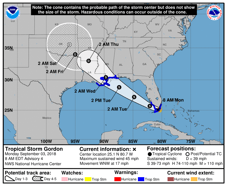
The National Hurricane Center upgraded PTC7 to Gordon this morning – a good decision based on the closed low level circulation via radar and observations in the Florida Keys. Forecast models have signaled Gordon’s formation for almost 6 days now, particularly the ECMWF EPS, which performed exceptionally well in indicating the potential for a Tropical Storm.
Gordon is forecast to track northwestward into the Gulf of Mexico over the next few days. The opportunity for strengthening is apparent, but the degree to which the storm intensifies remains in question and is not particularly “ideal”. Sea Surface Temperature over the potential track of Gordon remain near or slightly above normal using both 10 and 28 day averages. TC Heat Potential numbers are also moderately high.
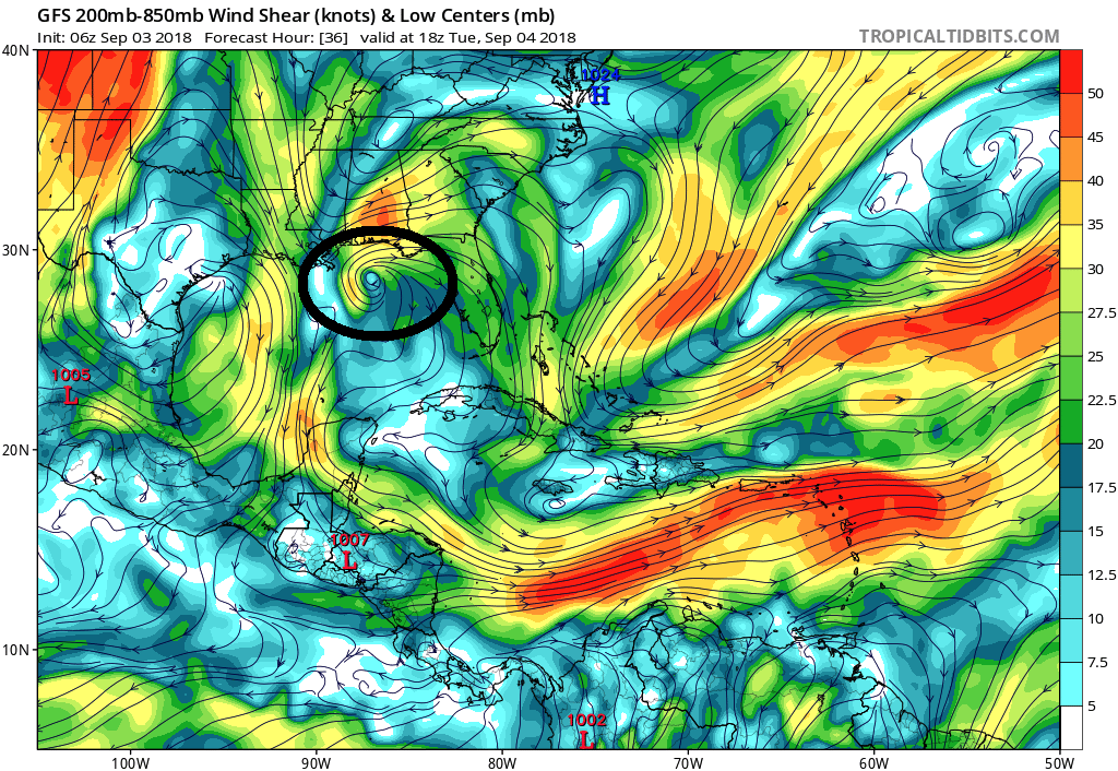
GFS suggesting Gordon may have the opportunity to strengthen amid lower shear and warm waters.
Meanwhile, short term forecast models suggest a favorable mid and upper level jet structure for Gordon. There is the potential for low shear and good venting in juxtaposition with the warm sea surface temperatures. This suggests the potential for additional strengthening – and while NHC suggests Gordon will strengthen into a more organized Tropical Storm, the feeling on our end is that there is a window for the storm to reach Hurricane status as well.
Interests along the Gulf Shores – particularly from Louisiana to Mississippi and Alabama, where Tropical Storm Warnings are in effect – should pay close attention to the status of Gordon over the next day or so. Always have a tropical storm plan in place if you live along these shorelines, and be prepared to use them over the next day or two if the storm does continue to strengthen and continue its northwest heading.
Further updates will be provided in the next 24 hours.
Florence continues slowly west – track a serious question
Tropical Storm Florence, meanwhile, remains a few thousand miles back to the east over the Eastern Tropical Atlantic. The system has plateaued in strengthening a bit, but remains generally organized as it moves steadily west/northwest into the Atlantic. Over the past few days, there have been major changes among forecast model guidance in regards to the systems potential track. These changes have stemmed from differences in how models are handling the mid and upper level pattern around Florence.
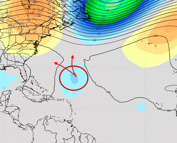
As Florence tracks northwestward, she will begin to encounter resistance from a mid and upper level ridge to her north. There will be a brief period where the storm will have the opportunity to track northward/eastward into the Atlantic Ocean – between two building mid level ridges (one over the Eastern Atlantic, and one over the Northwest Atlantic). However, models recently have shifted toward a solution that allows Florence to drift further west, then eventually trapping the system underneath a building ridge and shooting the system westward.
The “inflection point” with Florence – next week – as she approaches a gap in mid level ridging in the Atlantic Ocean.
This is obviously a more worrisome potential scenario for interests along the United States East Coast, as the storm system would essentially be barreling in that direction. However, the evolution of Florence remains incredibly uncertain at this time. There is an “inflection point” of sorts beginning to show up on model guidance, where Florence will either be far enough north to turn seaward, or too far southwest and forced to track underneath the mid/upper level ridge and surface high pressure.
The two major global model suites /ECMWF and GFS/ are split on how Florence will behave. The GFS is stronger and more organized initially, with Florence tracking further northward and then eventually seaward. The ECMWF and Ensembles are largely weaker and further south, eventually trapping Florence underneath ridging and forcing her to shift towards the United States next week.
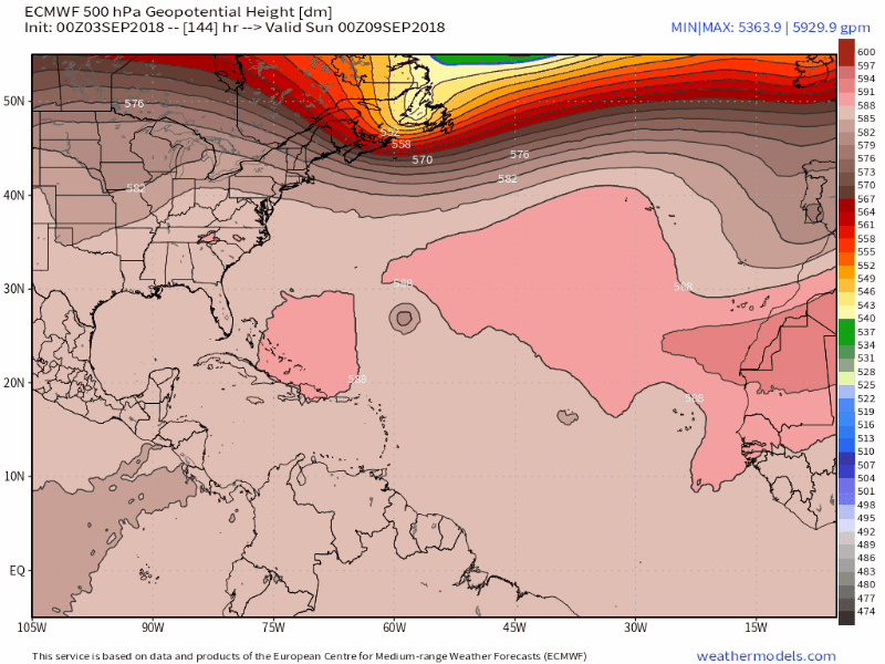
The ECMWF suggests that Florence will be trapped under mid level ridging and forced to turn westward towards the USA.
From a synoptic standpoint, there is no way to suggest that either model should be heavily favored at the present time. Florence is very far east in the Atlantic Ocean still – and medium range model guidance is still adjusting their handling of the pattern. However, if there was one solution to lean toward – it may be one which features stronger ridging over the Northwest Atlantic Ocean. This has been a recurring mid level pattern this season (over the past 2 months or so) and there is strong teleconnection support for it to continue during this time frame. With that in mind, there may be some credence toward leaning in the direction of the ECMWF’s idea.
Interests along the US East Coast should continue to closely monitor the track and forecast of Florence. While impacts from the storm are still 7 days away (if not more) the system’s track should begin to become more clear over the next 3-4 days. We will have further updates over the next 24 to 48 hours.
A Reminder: For official forecasts, please visit the National Hurricane Center.
Trackbacks & Pingbacks
1distillation
Leave a Reply
Want to join the discussion?Feel free to contribute!