-2")
Florence strengthening, track close to USA still possible
Hurricane Florence is still a few thousand miles away from land in the Atlantic Ocean, but forecast models have been throwing up all kinds of red flags in regards to her potential track – and impacts – over the past 48 hours. The systems eventual evolution remains incredibly complicated, modulated by several different features in the mid and upper levels of the atmosphere – and likely will not become clear for several days. Still, trends and ensemble signals have become more worrisome over the past few days in regards to Florence’s eventual future.
The system is currently located in the open Atlantic Ocean, 1210 miles away from the Northern Leeward islands. Florence is a Category 2 hurricane on the Saffir-Simpson scale, still shy of Major Hurricane status, but strengthening. It is doing so despite a relatively unfavorable environment, with sub-ideal sea surface temperatures and light to moderate wind shear. Forecast models have largely underestimated the systems intensity thus far.
Florence is expected to continue on a northwest heading for a few more days. Some fluctuations are possible, but the storm is expected to generally continue as a Hurricane. It may briefly weaken for a period of time while encountering more sub-ideal conditions. The system will continue northwestward through the end of the week into the Central Atlantic, and as we approach the weekend the forecast will take very complicated and critical turn.
As Florence churns northwestward, several complicated interactions will be occurring over the Northern and Central Atlantic Ocean. A trough is forecast to move from Eastern Canada into the Northern Atlantic Ocean this weekend, coming nearest to Florence from Sunday into Monday. Meanwhile, directly behind that trough, significant mid and upper level ridging is forecast to build from the Eastern United States into the Western and Central Atlantic Ocean.
Earlier forecast model runs, including ensemble guidance, had suggested that Florence would track far enough north – and the aforementioned troughing would track far enough south – so that the steering flow would turn Florence northward and towards the troughing. The storm would eventually be scooped seaward, turning north into the Central Atlantic Ocean and moving harmlessly away from any major land interests.
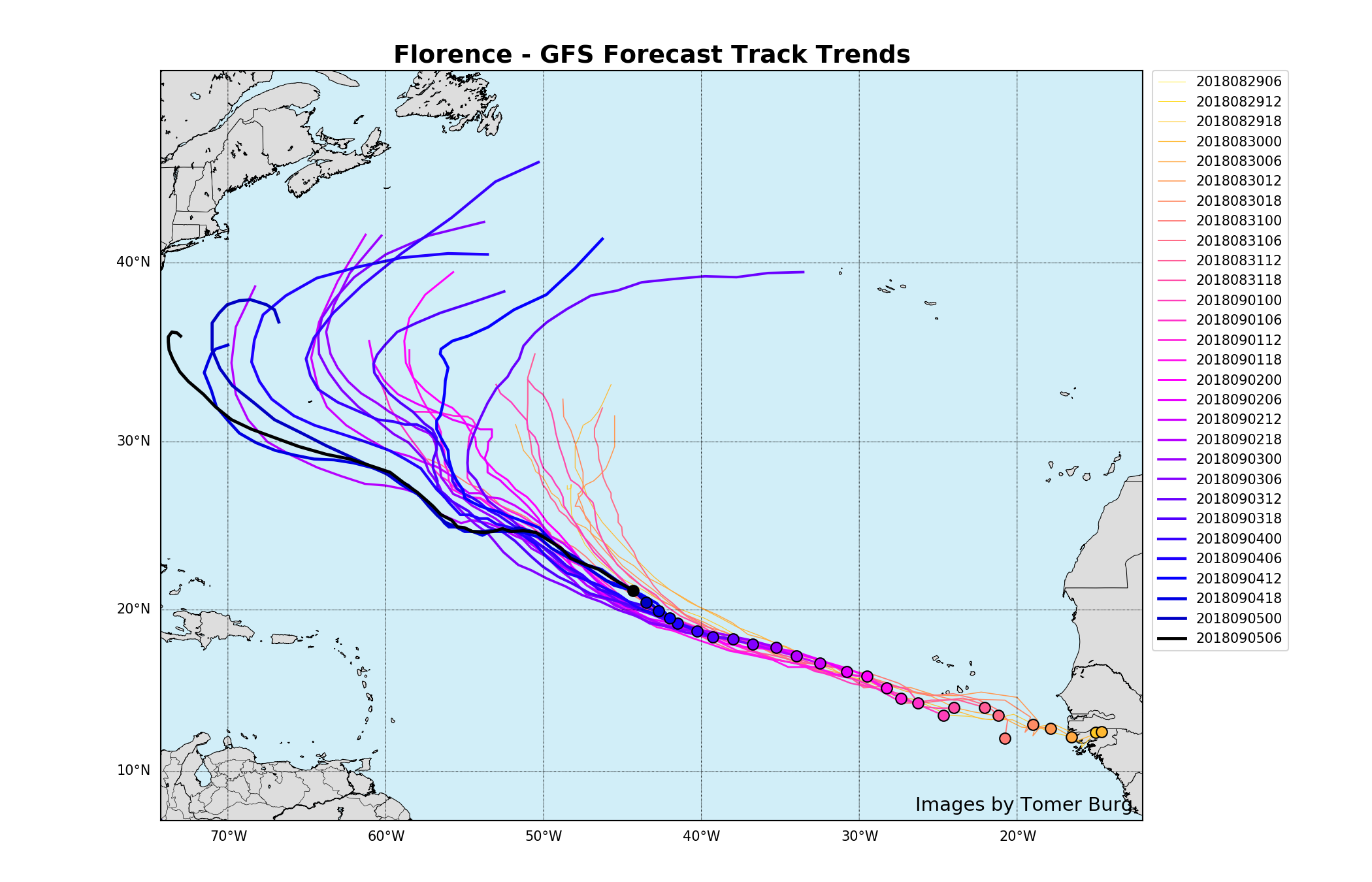
The GFS has trended steadily west with the track of Florence over the past several days.
Over the past 48 hours, however, forecast model guidance has taken a different turn. The trough over the North Atlantic Ocean has trended weaker and more progressive, while Florence has trended a bit stronger and further south. This “gap” between the two features means that mid and upper level ridging has a chance to build in quickly and more effectively. As Florence drifts westward, ensemble guidance is now suggesting that she may miss the “connection” with that Northern Atlantic trough entirely. The end result:
She is trapped.
With the missed opportunity for a northward turn, Florence drifts westward and then accelerates as she is caught in a new steering flow. The mid level ridging builds to her north and east, temporarily blocking any escape route. This puts Florence on a precarious and worrisome path towards the East Coast of the United States next week. To make matters worse, if this were to occur, the storm would be tracking into warm waters with the mid level ridge to her north and east providing the opportunity for strengthening.
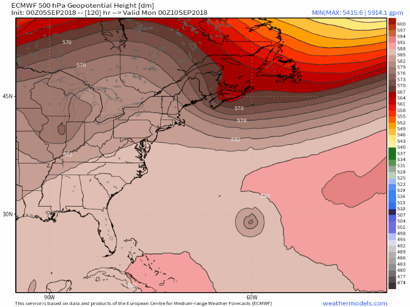
Forecast models are suggesting the possibility that Florence will be trapped by a mid level ridge to her north and east next week.
There appears to be an “inflection point” of sorts from Sunday Night into Monday. This is the period of time where forecast model guidance had been initially suggesting that Florence would track northward, interacting with troughing and turning seaward as she approached 30N. Most recently, model guidance has abandoned this idea and suggests that Florence will turn westward instead, approaching the East Coast.
It will be critical over the next few days to monitor where Florence tracks – both in relation to forecast model guidance, and also in relation to the main features in the mid and upper levels of the atmosphere. For meteorologists, analysis and observations will be just as critical if not more critical than looking at medium range models.
Even if a westward track occurs, forecast model guidance then diverges significantly, with some models suggesting a very late recurve of the storm as Florence slows and plays chicken with the East Coast before turning seaward. Others suggest the system continues westward and impacts the US East Coast to some degree next week.
So what happens now?
Right now, nothing happens other than us meteorologists continuing to carefully analyze Florence’s observations, track, intensity, and forecast model and ensemble trends. The next few days will be critical – particularly as we approach the weekend. If Florence does not turn northward and interact with troughing in the North Atlantic this weekend, the probability of impacts along the US East Coast of some degree (high surf, rip currents, or even direct storm impacts) increase significantly. If it does end up further north, it may still make a harmless seaward turn.
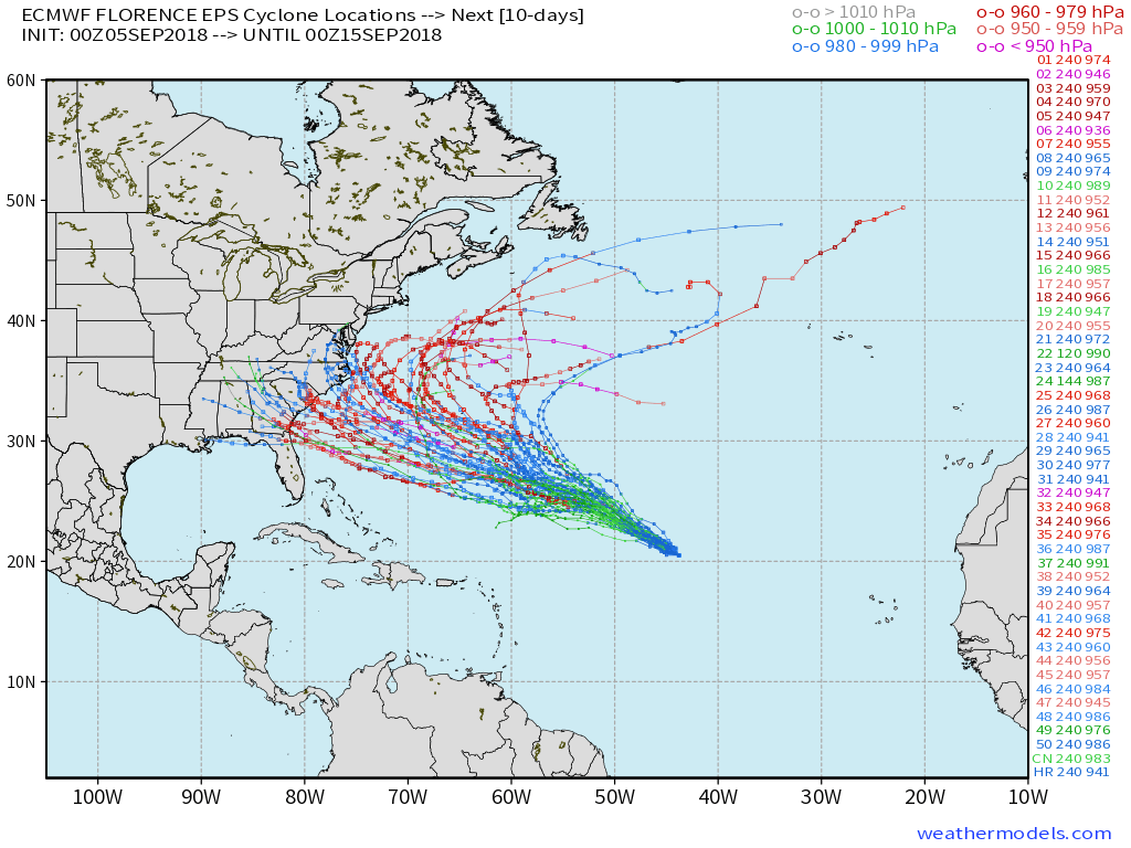
There are still several possibilities in regards to the track of Florence, as visualized here on the ECMWF Ensembles.
If you live in the Southeast US or along the US East Coast, it never hurts to go over your tropical storm/hurricane plan. Know your evacuation routes, understand flood zones, etc. These are things that you should do every year, but it doesn’t hurt to brush up on it when a tropical system is drifting through the Atlantic with track uncertainty.
Keep it right here over the next few days for the latest information as we get it.
As a reminder, we produce these free posts because we love them and you do too. But it would be really cool if you passed along information regarding our Consulting or Enterprise services to a friend that needs it (maybe it’s you!). Cheers!
Leave a Reply
Want to join the discussion?Feel free to contribute!