-2")
Multiple disturbances, unsettled weather likely this week
Welcome to Autumn! Although meteorological Autumn began on September 1st (which, if you ask us, is still a more accurate demarcation line for the season), Autumn officially began Saturday Night at 9:54pm. The weather cooperated quite a bit, as well, with a beautiful day on Saturday throughout much of the Northeast states. Behind a frontal boundary, skies partially cleared and drier, less humid air moved in.
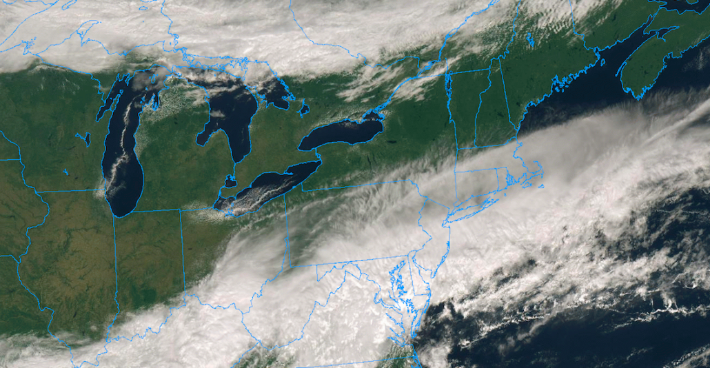
You may have noticed that the weather this morning is quite a bit different. The frontal boundary which moved through Friday barely sunk far enough southward into the Mid-Atlantic, and as a disturbance rode along it this morning it has moved further north once again. This has left many areas in the Mid-Atlantic, including parts of Southeast Pennsylvania and New Jersey, dealing with rain once again. Clouds have streamed into New England as well, with only Northern New England escaping and enjoying some sunshine.
Monday and Tuesday
The weather is expected to remain quite unsettled this week, as multiple disturbances move through and an active pattern continues. The first half of Monday may be the only salvageable part of the weeks first half, with cloudy but mostly dry conditions across the Northern Mid-Atlantic and New England. By Monday afternoon, a disturbance moves northward and moisture does so as well, with rain chances steadily increasing from the Mid-Atlantic into New England.
By Monday evening and Tuesday morning, a period of steady rainfall is expected. Localized flooding may even be possible during this time frame as moisture increases and the rainfall becomes steadier and heavier for a period of time. All of this will be associated with a warm front, which is expected to move into Pennsylvania, New Jersey and New York by Tuesday afternoon. The weather pattern gets a bit tricky at that time, with instability increasing just south of the warm front during the afternoon hours.
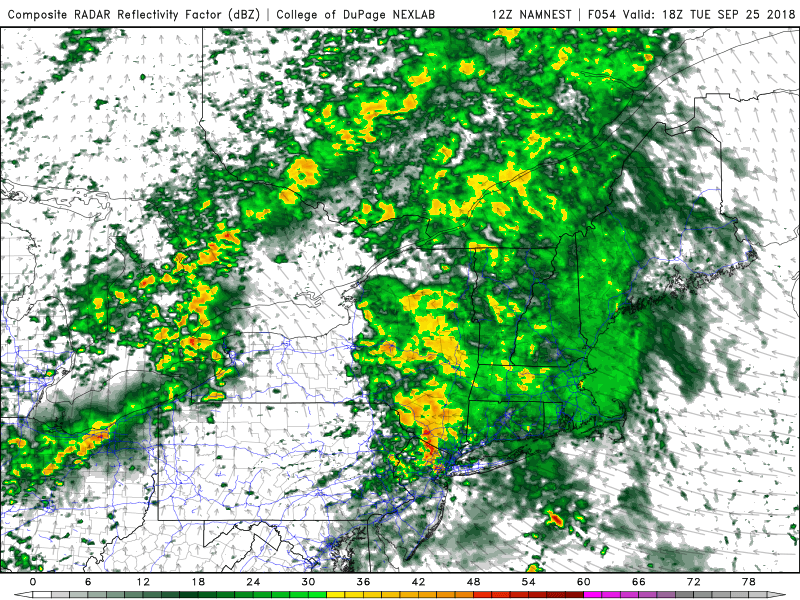
A few strong to severe storms are possible Tuesday afternoon near a warm front.
If the instability can align near/along the warm front, the potential could exist for a few isolated to scattered stronger storms, some of which could produce gusty winds and an isolated tornado near the warm front in Eastern PA, Northern NJ, Southeast NY or Southwest CT. These setups are always a low probability event – but always are worth watching as warm fronts often feature enhanced shear that can quickly organize storms.
The warm front is expected to shift northward by Tuesday evening. A brief “break” in unsettled weather is expected, as the atmosphere becomes increasingly moist and also more unstable. A cold front lurking to the west-northwest will bring our next bout of unsettled weather with it
Wednesday
The most active day of the week is largely expected to be Wednesday, with a cold front shifting southward through New England and the Mid-Atlantic states. As it does so, it will encounter a few key atmospheric features that will promote the development of strong/severe storms: Favorable wind shear, good lift for storm development, and marginally favorable instability. As a result, strong to severe thunderstorms are expected as the front shifts southward Wednesday afternoon.
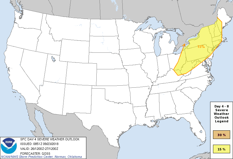
The Storm Prediction Center has placed much of the Northeast US in a 15% risk for severe storms on Wednesday.
The Storm Prediction Center has placed much of the Northeast states in a 15% risk for severe thunderstorms on Wednesday, at an advanced lead time, which suggests at least a “Slight Risk” once categorical risk areas get introduced on the Day 3 outlook on Monday. Thunderstorms are expected to develop near the front during the afternoon and shift southward, likely posing a risk for damaging wind gusts, lightning and torrential rainfall.
While instability is moderate, it is somewhat disjointed from the best wind dynamics, which suggests the threat will remain a bit unorganized – in other words, not a widespread severe weather threat or outbreak. Still, scattered severe storms are expected and residents should remain weather aware as Wednesday approaches.
Thursday through Friday
The front clears the coast on Thursday morning, with cooler weather shifting in to the Northeast states. Most forecast models suggest that the back half of the week will be dry, but a few still are hinting at the possibility of another disturbance on Friday. Still, any showery activity will likely be much more sporadic in coverage than the disturbances from the first part of the week.
Cooler and generally drier, more quiet weather is currently expected for the weekend ahead.
The main takeaway is that cooler and drier weather moves in as we approach the weekend, and generally calmer and cooler weather is expected for a few days. There are signals that some of the coolest weather of the season so far will move into the Northeast during the middle of next week, but that’s a bit far out to begin speculation at this time.
For now, enjoy the rest of your Sunday – and be sure to check back on social media during the start of the week as we track multiple disturbances and active weather. As a reminder, if you are looking for more detailed, personalized forecasts for your personal or business use, we do provide Enterprise level products. Check them out.
Leave a Reply
Want to join the discussion?Feel free to contribute!