-2")
NYC Area Forecast: Heavy rain this evening, better weekend ahead
Showers and thunderstorms will become increasingly prevalent throughout the area this afternoon, culminating in a threat of heavy rain throughout the area tonight. This will lead to localized flooding, and torrential rain may continue until the late evening or even midnight in many areas. The rain wraps up gradually later this evening with improving conditions expected on Saturday.
Today and Tonight | Weather conditions deteriorate
We were able to salvage the morning today, but that’s all we’re going to get away with. Showers are becoming frequent throughout the Northeast and Northern Mid-Atlantic this afternoon, and steady rain is already spreading northward from Pennsylvania. This is expected to expand, with lift and moisture increasing ahead of strengthening southerly low-level jet. This jet may also help to enhance embedded low-topped or elevated storms with torrential downpours. These downpours could lead to localized flash flooding, for which the National Weather Service has issued a Flash Flood Watch in Northern New Jersey, Southeast New York and New England.
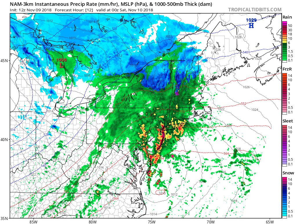
3km NAM model showing rain with embedded torrential downpours and possible thunderstorms over New Jersey and NYC areas this evening.
It will also become breezy this afternoon and evening, with winds gusting between 20-30mph. A stout inversion and stable marine layer will keep much of the stronger winds from the 50-60kt low-level jet aloft from mixing down into the surface, but we can’t rule out a few isolated stronger gusts with added momentum produced from any storms. High temperatures today will be generally be in the low to mid 50s throughout the region. Tonight’s lows will be in the mid 40s over NYC and urban areas, and upper 30s to lower 40s pretty much elsewhere.
Saturday through Monday| Tranquil and colder
Clearing skies and breezy conditions are expected behind the cold front on Saturday, with highs in the middle to upper 40s. Cold weather settles in on Saturday Night as well. A colder high pressure from the Northern Plains will move over the Ohio Valley and Mid-Atlantic on Sunday, with mostly sunny skies and calm winds.
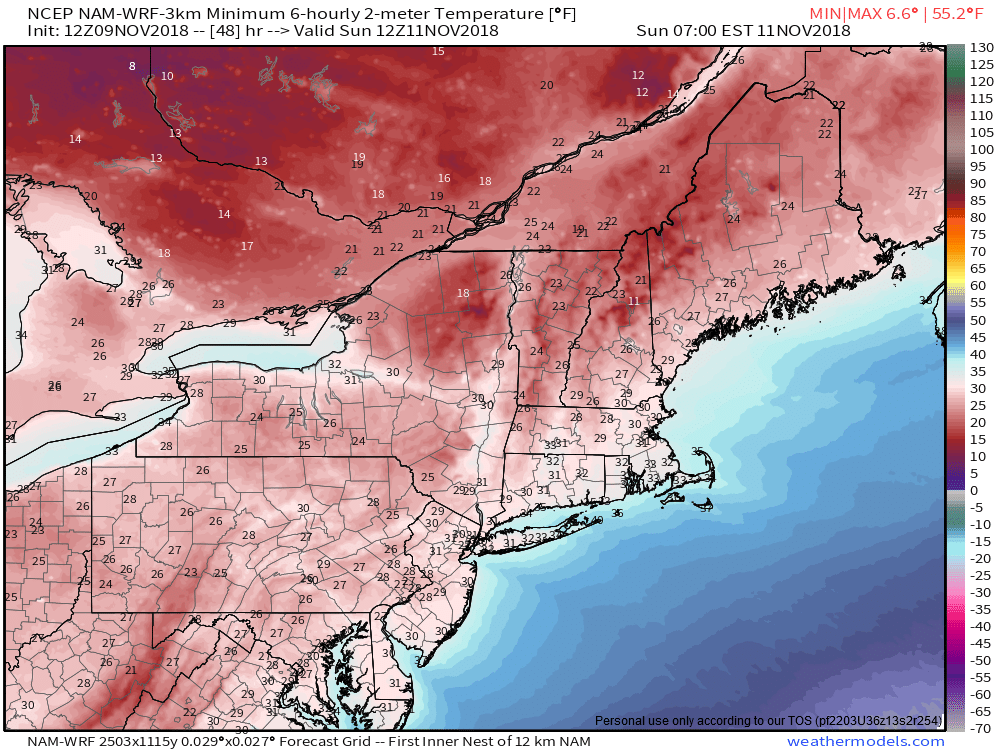
3km NAM model forecasting temperatures in the 20s and lower 30s for Saturday night/Sunday morning over the Northeast
We will start off the new work week with fair and chilly weather again on Monday. However, clouds will begin increasing by the afternoon and evening hours, as high pressure begins to depart offshore and the next storm system approaches. A light southerly flow developing may help temperatures moderate a little, but the increasing clouds will likely keep highs in the upper 40s to around 50, throughout the Northeast on Monday.
Monday night through Midweek | Stormy weather returns
A larger east coast storm will develop early next week, with a full-latitude trough amplifying over the Ohio Valley. A broad area of low pressure will organize over the Southeast US on Monday then track north-northeastward into the Northern Mid-Atlantic and Southern New England. This will allow rain to expand northward from late Monday Night into Tuesday.
There is currently some uncertainty on exactly where this storm will track, and how quickly it will intensify and consolidates. This leads to a lower confidence forecast on details and specifics – including precipitation timing and, further north in New England, precipitation type. Most guidance indicates that a strong low-level jet with a plume of Atlantic/Gulf of Mexico moisture will surge northward with the storm system.
Accordingly, there will be the potential for heavy rainfall and strong, gusty winds, especially for parts of the Northern Mid-Atlantic and Southern New England. Further inland and in New England, enough cold air may get involved that wintry precipitation will occur – and some accumulations are possible in Upstate New York, Northern Pennsylvania, Vermont, New Hampshire and Maine.
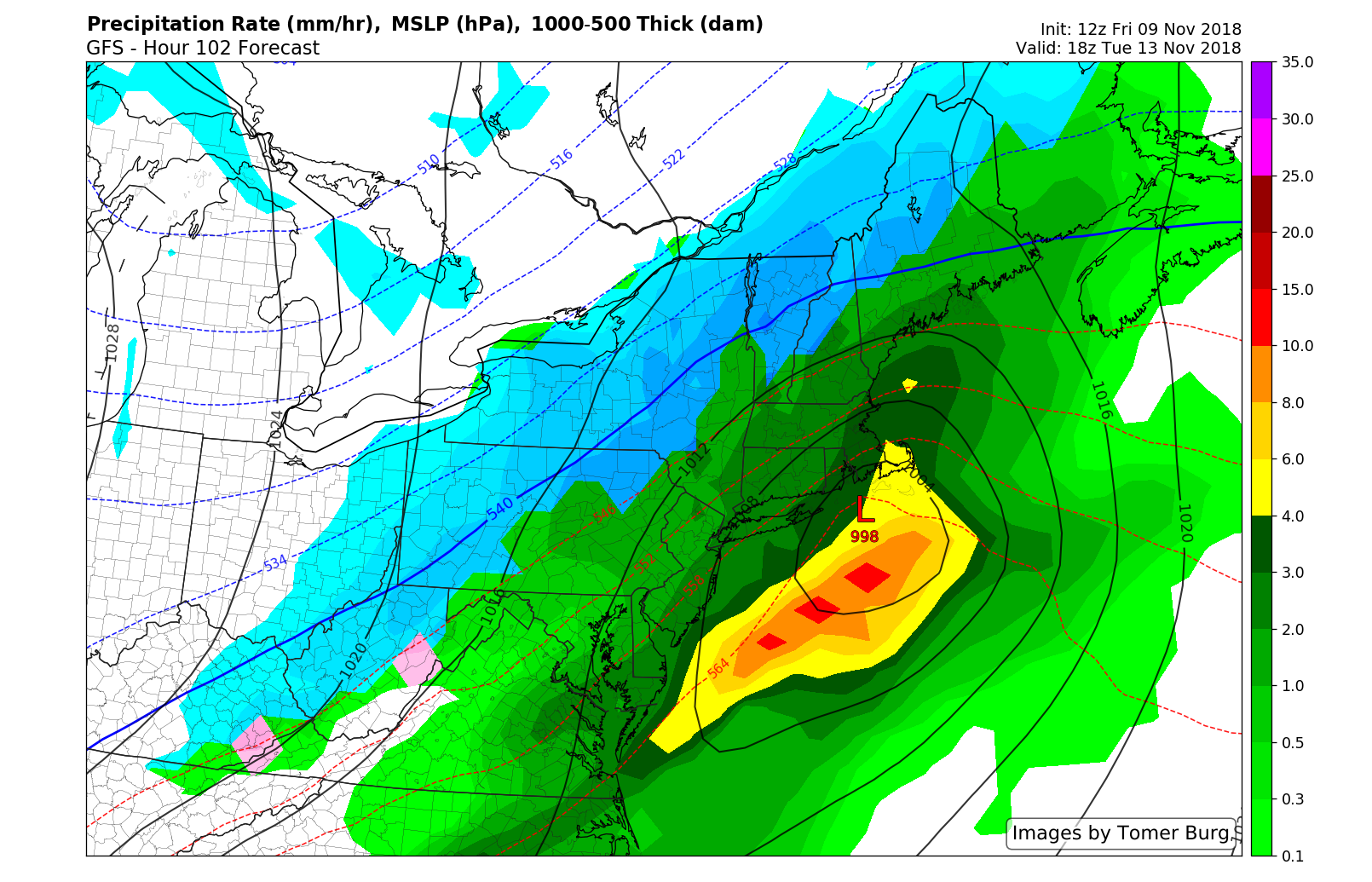
GFS model showing the large storm system impact the Northeast with heavy rainfall near the urban I-95 Corridor and some snowfall/wintry mix for Northern Interior areas of the Northeast Tuesday
Improving weather is expected by Wednesday and Thursday of next week, as this storm continues tracking northeast into the Canadian Maritimes. An even colder airmass will surge in behind this storm over the Northeast US. High temperatures may only reach the lower to middle 40s- and overnight lows may be the coldest of the season thus far.
More information coming your way this weekend on all of the upcoming storm systems – so stay tuned! Also please take a moment to check out our Consulting page if you looking for more detailed, daily forecasts for your location or business.
Leave a Reply
Want to join the discussion?Feel free to contribute!