-2")
NYC Area Forecast: First winter storm threat of the season late week
Briefing: A winter storm threat will evolve late this week, with the potential for snow in the Mid Atlantic and Northeast. Some snow is possible in NYC, but accumulating snow is much more likely in the interior.
A unique and unusual synoptic weather pattern will evolve this week leading to the potential for the seasons first winter storm, especially in the Interior parts of the Northeast. Even in the immediate suburbs of NYC, a few inches of snow may accumulate on Thursday on the front end of the storm system.
The storm system begins to evolve from Tuesday into Wednesday, as a cutoff low moves from the Mississippi River Valley towards the Mid-Atlantic states. Meanwhile, a deep trough in Southeastern Canada will reinforce cold air over New England. Very low dew points will sink southward into New England as a result – and this cold antecedent airmass will be a key to the forecast on Thursday.
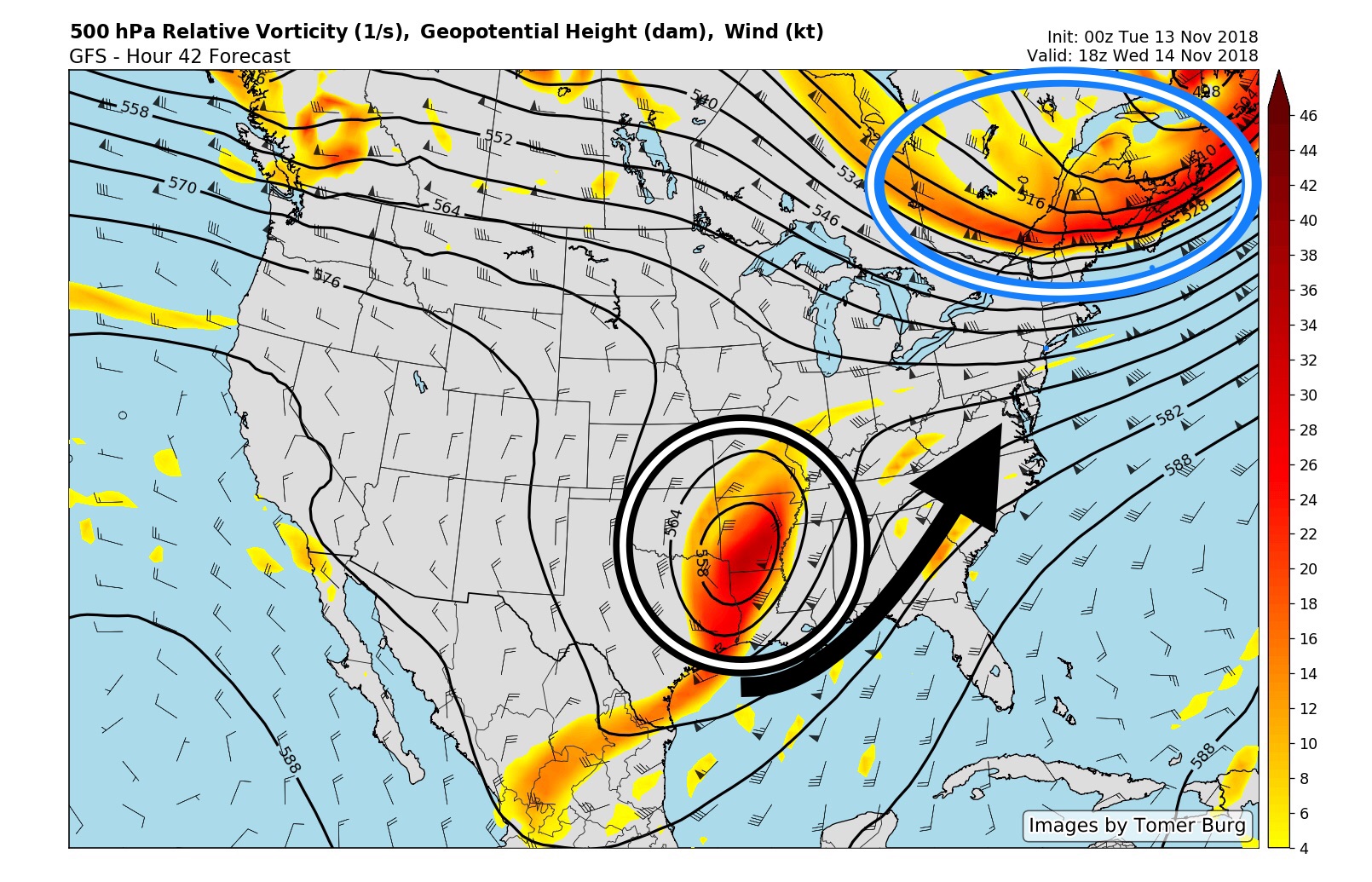
Cold air will be reinforced as the system approaches via a deep trough in Southeast Canada.
Precipitation is expected to expand northward through the Mid-Atlantic on Thursday, especially from late Thursday morning into Thursday afternoon. As it does so, the affects of the cold air sinking southward will become apparent, as almost all reliable forecast model guidance suggests that precipitation will start as snow even in areas such as Southeastern PA (including Philadelphia), New Jersey and New York City.
How much snow falls will remain an extremely complicated forecast right up to the event itself. Why? The precipitation is being driven mostly by a process called “warm air advection” – or the movement of warmer air through multiple levels of the atmosphere. Southerly winds will be pushing warm air northward, so even despite the cold air at the surface, precipitation will eventually turn to a wintry mix and then to rain.
The timing of exactly when this occurs will be critical. A band of heavy precipitation is likely to traverse the Mid Atlantic states and push towards Pennsylvania, New Jersey, New York City and Connecticut by later Thursday afternoon. If enough low level cold still exists during this time, the potential would exist for light to moderate snowfall accumulations, especially away from the coast. If the warmer air has already surged northward, that potential would likely be confined to the higher elevations of Northwest NJ and NY State.
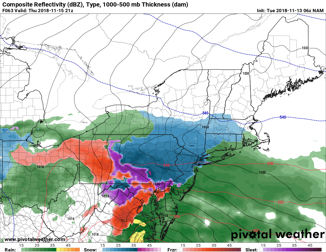
Most models suggest precipitation will begin as snow in the Mid Atlantic on Thursday afternoon.
Our forecast currently leans towards the slightly colder solutions, but does allow for some warming and a change to rain during Thursday afternoon. Accordingly, we are suggesting a few inches of snow in the immediate NYC suburbs, the first real snow for NYC Metro but minimal accumulations, and a more significant snowfall event across the Interior.
Regardless of what happens Thursday afternoon, by the evening hours precipitation will change to rain near the coast, with steady and heavy rain distinctly possible. This won’t be the case across the Interior, including parts of Pennsylvania, New York, Vermont, New Hampshire, Massachusetts and Maine – where guidance suggests another round of significant snowfall is possible as the system organizes. Snow could continue there until Friday.
Stay tuned today and through the middle of the week for further updates as the storm system evolves – including the details on the potential for snowfall accumulations, timing and more. As a reminder, if you need detailed, accurate and personalized forecasts for your business or operation – contact us right here.
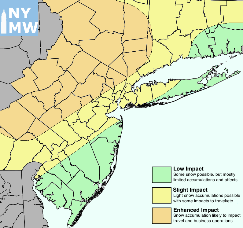
Our latest impact map.
Really appreciate your forecasts – straight to the point, well written AND understandable to someone like me who isn’t a weather expert! Thank you.
Just saw this, somehow, thank you Maureen! Thanks for reading!