-2")
NYC Forecast: Severe storms possible Sunday, Isaias impacts next week
Several weather hazards are expected over the next few days in the NYC Metro Area. Warm and humid conditions will continue. Severe thunderstorms are possible on Sunday afternoon and evening. Heavy, tropical rainfall is possible on Monday. Additional heavy rainfall is expected as Tropical Storm Isaias moves towards the area by midweek.
QuickCast
This evening: Pleasant weather conditions are expected early on, with low temperatures in the 70’s. A few storms over the Mid-Atlantic will move towards the area later tonight, with a warm front moving toward the area by morning.
Sunday (8/2): Warm and humid conditions are likely with highs ranging from the upper 80’s to lower 90’s. Strong to severe thunderstorms are possible during the afternoon – with the threats of damaging winds, lightning and a few tornadoes. Conditions will improve later in the evening.
Monday (8/3): In and out sunshine early, followed by showers and thunderstorms increasing in coverage and intensity by afternoon. Expect torrential, tropical rainfall in these thunderstorms and the potential for localized flooding.
Severe storms possible on Sunday
A potent atmospheric disturbance is forecast to move into the Northeast states on Sunday, setting the stage for a very active afternoon and evening. During the morning hours, a warm front will lift northwards from the Mid-Atlantic states. This front will position itself north of New York City by the late morning hours, somewhere in the Hudson Valley region. South of the front, atmospheric instability will quickly increase.

With the presence of the mentioned disturbance will come seasonably strong wind shear (for early August standards) and wind profiles. The juxtaposition of this approaching disturbance, instability, and wind shear will lead to the potential for strong to severe thunderstorms during the afternoon and evening throughout the Northeast.
The main threat with developing thunderstorms will be dangerous lightning and strong, damaging winds. With that said, wind profiles suggest that the atmospheric regime will be supportive of supercell thunderstorms, which are infrequent in this part of the country. These rotating thunderstorms can and sometimes do produce tornadoes. The potential for tornadoes, while not high at any specific location, is slightly higher than your “typical” summertime thunderstorm event in the Northeast.
Tropical Storm Isaias impacts likely next week
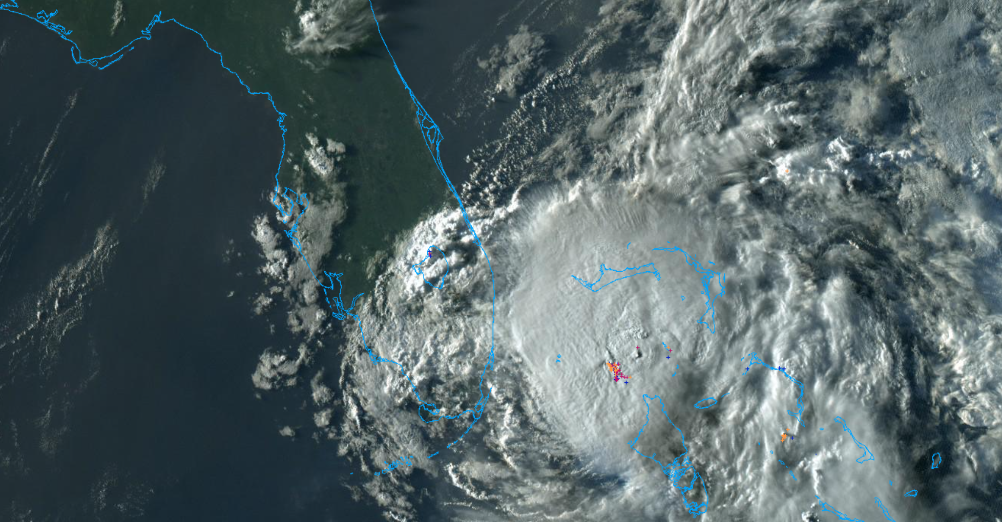
Tropical Storm Isaias is still meandering off the coast of Florida this evening, and has recently been downgraded from a Category 1 Hurricane. Still, the National Hurricane Center expects the storm to restrengthen, and is forecasting a hurricane to come close to the Florida coastline on Sunday.
Isaias is expected to turn northwards up the East Coast early next week. Moisture from this system will be advected into the area while the storm is still several hundred miles away. This will lead to the potential for heavy, tropical rainfall as early as Monday afternoon and evening. The potential for flooding rains will continue through Monday Night.
On Tuesday, Isaias is forecast to track along the East Coast, and may pass very close to the area. As it approaches, we anticipate the potential for heavy rainfall and flooding – from Monday Night through Tuesday. Several inches of rainfall are possible in the area, and localized flooding could become a serious concern. If you live in a flood prone area, now is the time to have a plan in place and begin to explore options in the case that you need to evacuate or relocate.
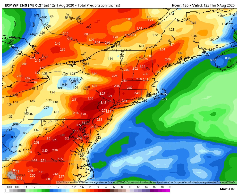
Forecast models suggest that heavy, tropical rains may be accompanied by gusty winds – but the wind gusts are not expected to be the main story with this event. The expectation is that Isaias will be weakening as it moves up the coast, and heavy rainfall will be the headline in the NYC Metro Area.
We’ll have a detailed update on Sunday with timing, hazards, and preparedness information as Isaias begins to track towards the East Coast.