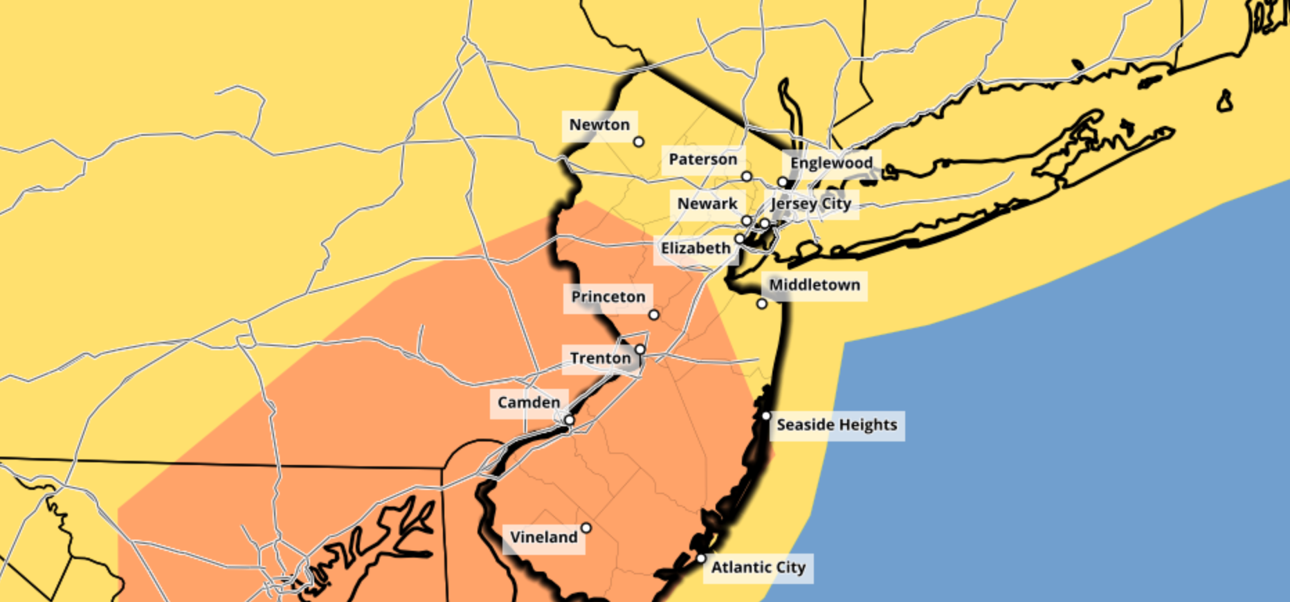
The Storm Prediction Center has placed parts of New Jersey and Pennsylvania in an Enhanced Risk for severe thunderstorms on Tuesday. The main threat with thunderstorms that develop will be strong, damaging wind gusts. Dangerous lightning and small hail also cannot be ruled out.
https://www.nymetroweather.com/wp-content/uploads/2020/08/Screen-Shot-2020-08-24-at-2.13.46-PM.png8701864John Homenukhttps://www.nymetroweather.com/wp-content/uploads/2024/02/Empire-2000-x-300-px-2.pngJohn Homenuk2020-08-24 14:15:452020-08-24 14:15:53NYC Forecast: Enhanced Risk for severe storms on Tuesday
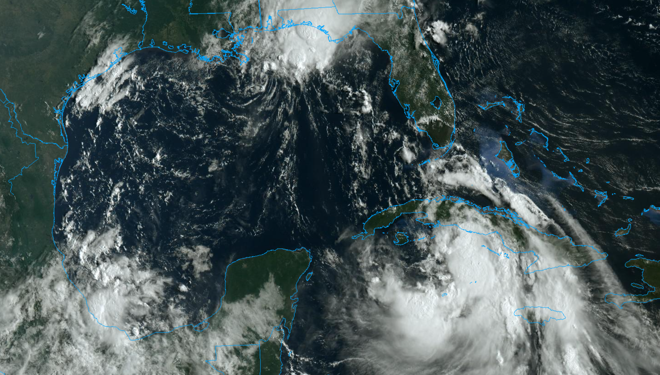
Tropical Storm Laura continues its trek through the waters south of Cuba this morning. The storm has managed to avoid significant land interaction thus far, readjusting its center south of the shore. The National Hurricane Center says maximum sustained winds are 65 miles per hour. The system is expected to emerge into the Gulf of Mexico on Tuesday.
https://www.nymetroweather.com/wp-content/uploads/2020/08/Screen-Shot-2020-08-24-at-10.07.45-AM.png12262156John Homenukhttps://www.nymetroweather.com/wp-content/uploads/2024/02/Empire-2000-x-300-px-2.pngJohn Homenuk2020-08-24 10:15:102020-08-24 10:15:17Laura expected to track into Gulf of Mexico, threaten TX/LA coast this week
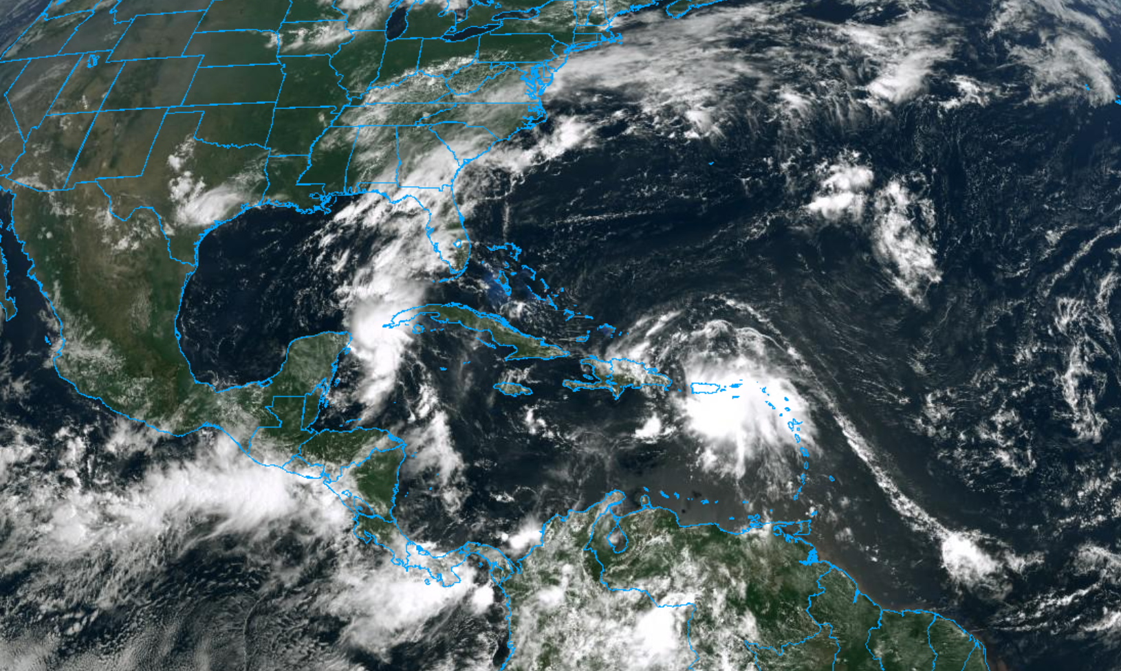
Atlantic tropical activity ramped up again this week, with Tropical Storm Laura forming east of the Northern Leeward Islands and Tropical Storm Marco forming in the Western Caribbean. Both systems are expected to enter the Gulf of Mexico in the coming days, and threaten the United States next week.
The uptick in Atlantic tropical activity was well forecast. A developing MJO wave and a CCKW propagating from the Pacific to the Atlantic gave meteorologists almost three weeks of warning. Now that tropical storms have developed, the uncertainty resides in where the systems will track and how they will behave as they do so.
Tropical Storm Laura
Tropical Storm Laura is currently 70 miles northwest of Port Au Prince, Haiti. It has maximum sustained winds at 50mph and is moving to the west-northwest at 21 mph. Tropical Storm Warnings are remain in effect for Cuba, Haiti, the Dominican Republic, the Southeast Bahamas and the Turks and Caicos Islands.
Laura has maintained it’s intensity so far, despite moving over Hispaniola. Favorable atmospheric condtions and orographic enhancement from the mountains of Hispaniola, has resulted in more intense-banding of convection just south and east of the low-level center. Laura’s track has shift slightly further south, closer to the southern coastlines of Haiti and Cuba. Thus Laura is more likely to maintain it’s intensity until it emerges into the Gulf of Mexico by Monday night or Tuesday.
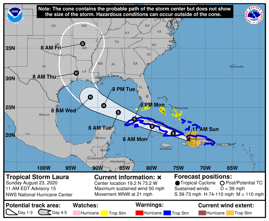
Laura is currently forecast by NHC to track further south over the Hispaniola and Cuba coastline with little strengthening expected through Monday. It will then emerge over the Gulf of Mexico, where it could strengthen into a major hurricane before impacting the Texas and Louisiana coasts by Wednesday and Thursday.
There is some concern for rapid strengthening of Laura once it arrives in the Gulf of Mexico. If the storm does emerge into the Gulf of Mexico next week, the environment which it encounters could be characterized by very low shear and very warm waters – rocket fuel for tropical systems.
Interests along the Gulf of Mexico coastline should carefully watch the evolution of Laura in the coming days.
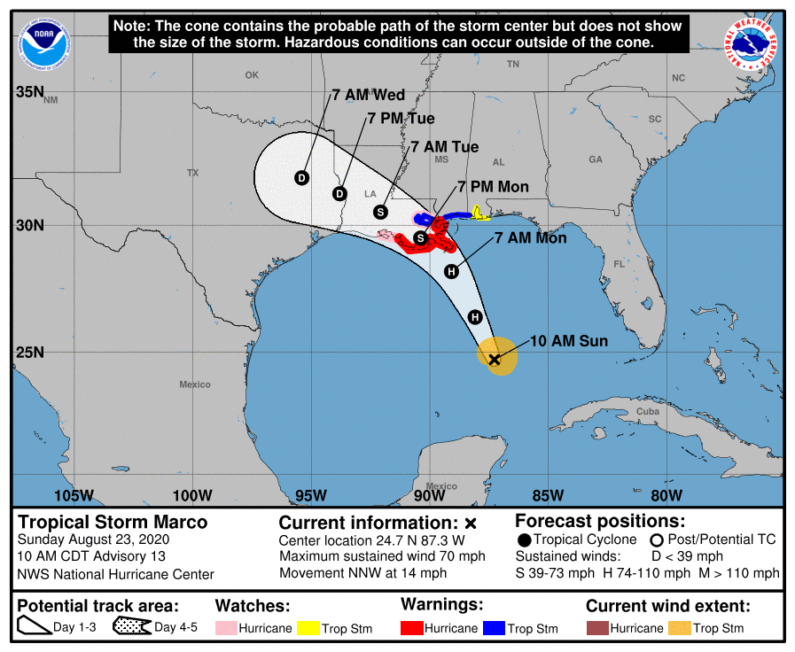
Tropical Storm Marco
Tropical Storm Marco is currently located in the South-Central Gulf of Mexico. It has maximum sustained winds at 70mph and is moving to the north-northwest at 12mph. Hurricane Warnings are now in effect for much of Southeast Louisiana. Marco is expected to become a minimal hurricane later today and impact Southeast Louisiana and Mississippi coasts on Monday.
As with Laura, there is uncertainty as to how Marco will behave once it enters the Gulf. The storm is generally expected to turn westward as a result of an upper level ridge, and may encounter more wind shear as a result. The official NHC forecast actually calls for the system to weaken back to tropical storm strength as a result. But when this happens is uncertain. Marco is small tropical cyclone, which can fluctuate in intensity quickly. Thus hurricane-force winds could still reach the coastline.
Uncertainty abound with both systems in Gulf
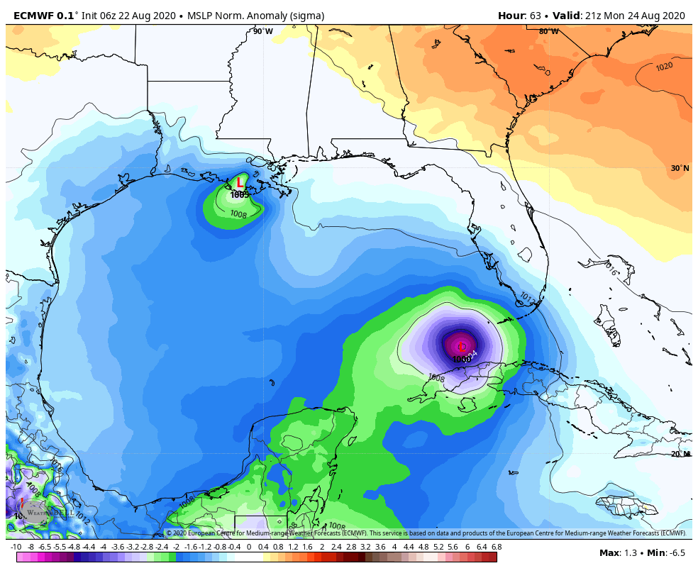
Both tropical systems are on a path towards the Gulf of Mexico over the next few days. This creates a tremendous amount of uncertainty, and forecast model guidance is struggling greatly to discern how each system will behave.
With both systems in the Gulf of Mexico, the tropical systems will almost certainly influence one another in some way. If they are close enough, it is possible that one tropical cyclone could grow stronger, negatively impacting the other – and vice versa.
ECMWF model showing both Laura (right) and Marco (left) in the Gulf of Mexico next week.
The strengthening or weakening of individual storms can also cause changes to the systems tracks and steering currents – commonly referred to as the Fuijiwhara effect, which is the binary interaction that can cause tropical systems to circle around each other or even merge. However, with Marco now expected to make landfall on Monday and Laura tracking further south and west over the Gulf of Mexico, chances of this interaction occurring have decreased.
There is a lot to consider with these possible interactions, and its worth noting that the tracks of the systems could change dramatically from the current forecast. If you live along the Gulf Coast of the United States, now is the time to prepare in advance. Do not focus on the exact forecast tracks of the systems at this time. Instead, make preparations in advance for a tropical system and adjust accordingly as the event draws closer.
https://www.nymetroweather.com/wp-content/uploads/2020/08/Screen-Shot-2020-08-22-at-11.54.48-AM.png9761630Miguel Pierrehttps://www.nymetroweather.com/wp-content/uploads/2024/02/Empire-2000-x-300-px-2.pngMiguel Pierre2020-08-22 11:56:392020-08-23 12:16:45Tropical Storms Laura and Marco headed into Gulf, will threaten US next week
Tropical Storm Kyle formed 300km southeast of Atlantic City, NJ this afternoon. The storm will move quickly away from land this weekend. Kyle is the 11th tropical system to form during what has been a historically fast start to the Atlantic Hurricane Season.
https://www.nymetroweather.com/wp-content/uploads/2020/08/Screen-Shot-2020-08-14-at-4.54.08-PM.png11881888John Homenukhttps://www.nymetroweather.com/wp-content/uploads/2024/02/Empire-2000-x-300-px-2.pngJohn Homenuk2020-08-14 16:58:562020-08-14 16:59:03Tropical Storm Kyle forms, expected to move away from East Coast
Hi friends! Our website uses cookies to provide an optimal browsing experience for you. New "Cookie Consent" laws mandate us to inform you of this. As long as you're cool with it, just hit OK. You'll only see this message once.
We may request cookies to be set on your device. We use cookies to let us know when you visit our websites, how you interact with us, to enrich your user experience, and to customize your relationship with our website.
Click on the different category headings to find out more. You can also change some of your preferences. Note that blocking some types of cookies may impact your experience on our websites and the services we are able to offer.
Essential Website Cookies
These cookies are strictly necessary to provide you with services available through our website and to use some of its features.
Because these cookies are strictly necessary to deliver the website, refusing them will have impact how our site functions. You always can block or delete cookies by changing your browser settings and force blocking all cookies on this website. But this will always prompt you to accept/refuse cookies when revisiting our site.
We fully respect if you want to refuse cookies but to avoid asking you again and again kindly allow us to store a cookie for that. You are free to opt out any time or opt in for other cookies to get a better experience. If you refuse cookies we will remove all set cookies in our domain.
We provide you with a list of stored cookies on your computer in our domain so you can check what we stored. Due to security reasons we are not able to show or modify cookies from other domains. You can check these in your browser security settings.
Other external services
We also use different external services like Google Webfonts, Google Maps, and external Video providers. Since these providers may collect personal data like your IP address we allow you to block them here. Please be aware that this might heavily reduce the functionality and appearance of our site. Changes will take effect once you reload the page.
-2")