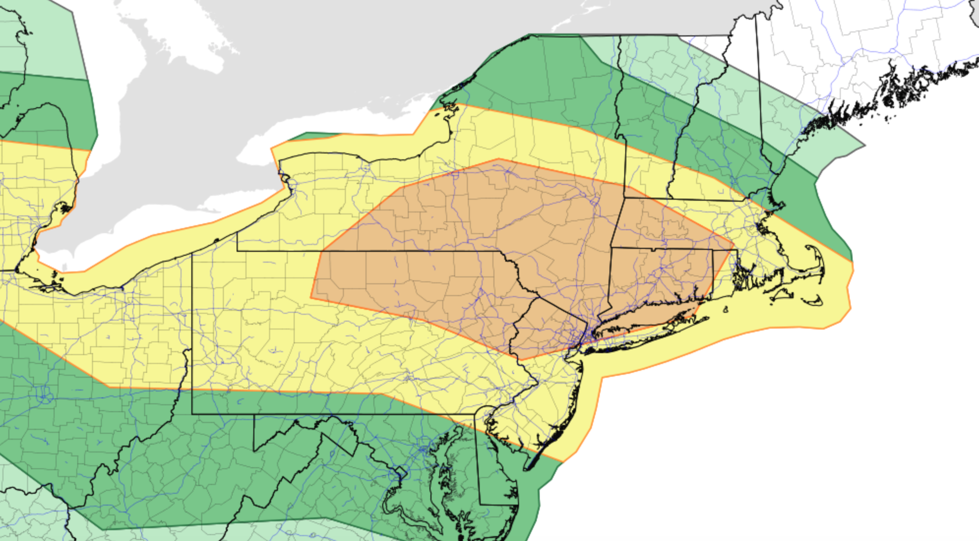
Enhanced Risk for severe thunderstorms in the Northeast today

Briefing: Showers and thunderstorms will develop this afternoon throughout New England. The combination of ample atmospheric instability and strong shear will lead to severe thunderstorms. These storms will be capable of producing strong winds, large hail, and a few tornadoes.

Timing: Initial thunderstorm development will occur between 1pm and 2pm across the Central New York capital region. These storms will quickly progress south and east along a warm front, towards the Lower Hudson Valley. Storms will reach Western Connecticut by mid-afternoon. Additional development will occur in the Lower Hudson Valley, movieg toward Long Island during the late afternoon and early evening.

Hazards: Damaging winds and large hail are the main threats, but a few tornadoes cannot be ruled out. Dangerous lightning and torrential rain is also expected.

Technical: Complex setup this afternoon

Mesoscale analysis this morning shows a warm front pushing northward through New England, with a moist and unstable airmass trailing it across the Mid-Atlantic states. Moisture advection in the mid/low levels of the atmosphere is increasing behind this front and will continue to push towards Central New England as the morning goes on. Forecast model guidance has been bouncing back and forth with the positioning of the effective warm front later today. Most recent guidance has settled in on a position near the New York Capital region.

There are some showers and thunderstorms ongoing along the warm front this morning as well. These are expected to persist in parts of Northern and Eastern New England, keeping many of those areas stable throughout the late morning and early afternoon. Gradually, the Capital region of New York, Lower Hudson Valley, and parts of Western Connecticut and Massachusetts should see clearing skies and increasing instability today.

Later this morning, atmospheric disturbance will shift into New England from Southeast Canada. This disturbance is easily recognizable on most recent short term models and observations. Height falls and lift associated with this disturbance are expected to aid in the development of thunderstorms later today.

The atmosphere near and south of the warm front will be characterized by moderately unstable air and impressively strong deep layer wind shear. Forecast soundings suggest mixed layer CAPE values over 2000 j/kg in some locations, juxtaposed nicely with 40-60kts of effective bulk shear. Some curving of low level wind fields is also present.

What does all of this suggest? In a nutshell, we can expect the development of strong to severe thunderstorms by early afternoon – and they should have no problem becoming organized and severe quite quickly. Supercells are possible initially, especially in the Capital region of New York. These storms will be capable of all severe weather hazards including a few tornadoes, large hail, and strong winds.

That leads us to around 4pm. From that point forward, uncertainty increases quickly. It remains unclear exactly how organized storms will be, and whether or not bowing clusters or segments can organize. Veering wind profiles and shallow low level moisture on some forecast soundings in the warm sector suggest that while wind damage is possible, storms may tend to remain a bit unorganized once they pull southward off the warm front. This means that we could see outflow boundaries or gust fronts surging southward from storms themselves, ending the severe weather threat for areas to the south.

If storms do organize – and perhaps a cold pool can organize in one or more complexes of storms – then a more substantial/widespread damaging wind event would be possible. Otherwise, individual storms near the warm front will be capable of all severe hazards before outflow boundaries and gust fronts begin to stabilize the atmosphere near/south of the front later in the afternoon.

Forecast of focused severe weather potential today. Refer to the Storm Prediction center for official forecasts.

Overview and what to expect

The main focus area for severe weather potential remains relatively unchanged, and in fact has become a bit more clear since yesterday. This focused area of potential arcs from the Capital region of New York southeastward into the Lower Hudson Valley. It then continues into parts of Western Connecticut. Damaging winds, hail, and a few tornadoes are expected in this region.

Further south, the severe weather potential remains more unclear. The possibility exists that gust fronts and outflow boundaries (winds being pushed out from other storms) could stabilize the atmosphere in this region and negate a more substantial threat. Still, isolated to scattered damaging wind and hail is possible this afternoon.

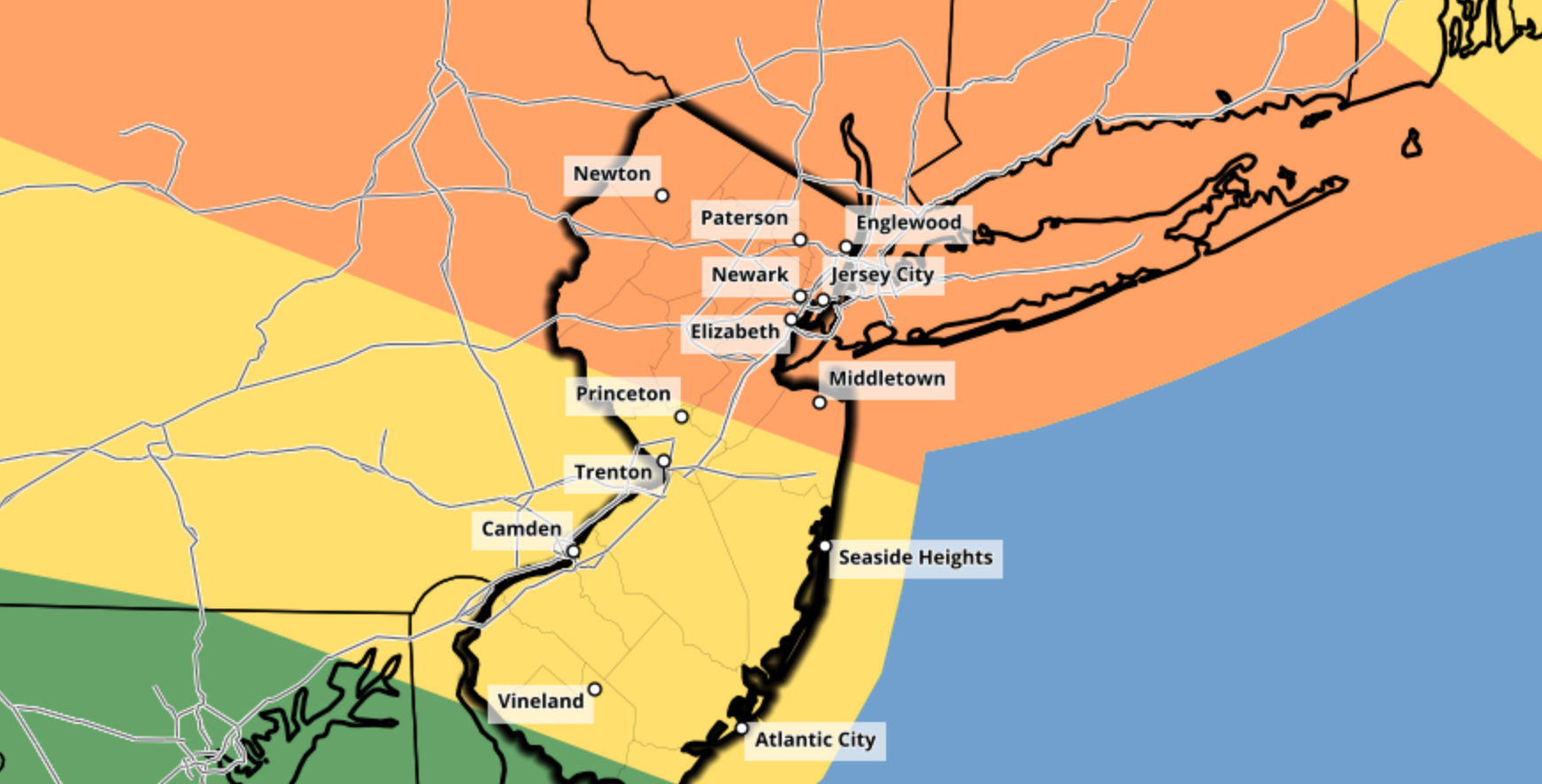
The Storm Prediction Center maintains an Enhanced Risk of severe weather for much of the aforementioned region.

Stay weather aware throughout the entire highlighted threat region and have a way to get weather warnings. If a warning is issued for your area, know where to go in your home to be safe until the storm has passed.

Dangerous hurricane Laura quickly approaching TX/LA coasts

Hurricane Laura strengthened into a major Category 3 hurricane this morning, and the system is still strengthening as of early this afternoon. The National Hurricane Center forecasts the storm to make landfall as a powerful Category 4 hurricane from later tonight into Thursday morning. The storm will pose a significant threat to life and property along the Texas and Louisiana coasts.

Latest observations and trends

Hurricane Laura began rapidly strengthening last night, and has continued to do so this morning. Satellite data shows a powerful hurricane, with cold cloud tops marking intense convection and favorable outflow channels allowing the storm proper ventilation.

Airplane recon data collected from the most recent pass in the storm shows continued strengthening. Maximum sustained winds at both flight level and estimated at the surface have increased. The storms pressure is falling and cloud tops are warming as Laura tries to clear out an eye.

Secondary wind maxima slightly further away from the main eyewall suggested the possibility that the storm may eventually undergo an eyewall replacement cycle, but recent trends suggest that the wind field may simply just temporarily become larger. Concentric eyewall features have not yet been observed.

An eyewall replacement cycle occurs when convection develops outside the hurricanes eyewall and becomes more robust and organized – just enough so to remove some of the intensity of storms within the eyewall itself. The original eyewall then proceeds to collapse, and a new eyewall (usually a larger one) develops from the new thunderstorms.

Eyewall replacement cycles are relatively commonplace in strong hurricanes, but we don’t truly have a complete understanding of them yet. Sometimes, stronger hurricanes don’t undergo eyewall replacement cycles as frequently as we think they will – instead, stronger thunderstorms outside the eyewall simply merge into the original eye.

If an eyewall replacement cycle does take place with Laura over the next 12 hours or so, the structure of the storms core would slightly change. Intense winds within the eyewall would decrease ever so slightly (ex: from 130 to 120mph), but the radius of the strong wind field would expand. While eyewall replacement cycles often weaken the intensity of the most severe winds, they allow “still-severe” winds to expand outward from the storms center.

Eyewall replacement cycle breakdown (Zhang, Tau, 2016)

It remains to be seen if an eyewall replacement cycle will occur with Laura today. In reality, the storm may not have enough time to begin or complete one. But satellite trends and observations will be continually monitored as the storm continues to evolve through this evening.

More reading on eyewall replacement cycles is available here.

The forecast for Laura over the next several hours features continued strengthening. The National Hurricane Center expects the storm to reach Category 4 status before it makes landfall along the Texas or Louisiana coastline. There is some hope that strengthening southwesterly wind shear could at least disrupt the storm as it approaches the coast, but the storm is still expected to maintain wind speeds as high as 145 miles per hour as it reaches the coastline.

Significant threat to life and property as Laura makes landfall

Hurricane Laura is forecast by the National Hurricane Center to make landfall as a dangerous Category 4 hurricane. Maximum sustained winds over 135 miles per hour will be capable of producing widespread damage and destruction. In addition, catastrophic storm surge from 9 to 15 feet above ground is forecast along parts of the Texas and Louisiana coast – an additional threat to life and property.

From the National Hurricane Center: “Unsurvivable storm surge with large and destructive waves will cause catastrophic damage from Sea Rim State Park, TX to Intracoastal City, LA.”

As it stands this afternoon, the landfall location of Hurricane Laura appears likely to be somewhere between Port Arthur, TX and Lake Charles, LA.

Residents in the path of Laura are urged to follow the advice of local governments and heed evacuation warnings and requirements. If you are still in the area and live along the coast, it is too late to make hurricane preparations – now is the time to evacuate.

For the latest, we recommend heading to the National Hurricane Center website and reviewing their latest briefings.

NYC Forecast: Severe thunderstorms possible on Thursday

After a dry and cool day on Wednesday, an active weather pattern will return. Strong and severe thunderstorms are possible on Thursday. The Storm Prediction Center has highlighted the region in an Enhanced Risk for severe weather. Unsettled weather will persist into the weekend, with additional severe weather possible on Saturday.

Read more

Laura strengthening, will approach Texas coast as a major hurricane

Laura was upgraded to a hurricane this morning, per the National Hurricane Center, with maximum sustained winds of 75mph. The storm is tracking northwest into the warm waters of the Gulf of Mexico. It is expected to strengthen considerably over the next 24-36 hours and approach the Texas coastline as a major hurricane.

The forecast track of Laura has shifted slightly to the left over the past 24 hours. This puts the Galveston and Houston metro areas closer to storm, raising significant concern for impacts in those regions as the storm comes ashore.

Latest observations and trends

Laura is displaying signs of increased organization this morning, with convection wrapping around the center of the storm. Visible and infrared satellite imagery suggest ncreasingly coherent inner core. Northerly shear continues, but deep convection has begun to wrap around the storms center. Pressure is dropping and is expected to continue to fall through the afternoon.

The most recent recon missions into the storm suggest that the vortex may still be ever-so-slightly tilted as a result of northerly wind shear. Vortex tilting is not uncommon, especially for storms emerging from interactions with landmasses or undergoing wind shear. Nevertheless, it is when the low/mid level vortex’s become stacked that the system could begin to intensify rapidly. We will be carefully watching for that throughout the day.

Laura is in the process of moving over very warm waters in the Gulf of Mexico, in an environment characterized by low atmospheric wind shear. This should promote continued organization over the next 24-36 hours. The National Hurricane Center is forecasting rapid intensification, with the storm reaching Category 2 strength later on Wednesday.

In the short term, Laura has once again been tracking to the south/west of model forecasts. This is a trend that has been consistently observed over the past 24-48 hours. Northerly wind shear is likely causing downshear convective development and organization, readjusting the storms low level center, which model guidance is handling very poorly.

Microwave imagery over Laura showing the storms developing inner core.

In the next 12 hours or so, Laura will continue to traverse warm waters in a low shear environment. Organization should be steady to start, but may pick up in speed by tonight. The storm may cross a cooler eddy over parts of the Central Gulf tonight/tomorrow morning that may temporarily limit intensification, but it will then emerge back into warm waters shortly thereafter.

Major hurricane will target Texas coast

All global models and ensembles agree that Laura will target the Texas coastline as a major hurricane by the middle of this week. The forecast track has shifted slightly to the left over the past 24 hours, which puts areas like Galveston Bay and the Houston metro area in a precariously close position to the storms track.

Overnight EPS and GEFS ensembles both shifted slightly west, with a growing cluster of ensemble members tracking Laura close to Galveston Bay as a major hurricane. This trend has persisted for the past 24 hours – and is likely not unrelated to the short term trends of the storm verifying to the south/west of model positions.

Models have been trending west with Lauras track, bringing the storm closer to Houston and Galveston.

The main uncertainty with Laura’s track continues to relate back to its strength, and the steering of the storm as it moves over the Gulf of Mexico. Yesterday, we broke down the differences in model guidance as it relates to the systems strength. A stronger Laura, trending further southwest over time, is less susceptible to wind shear – and also is steered more westerly by the upper level/enfironmental winds.

A weaker Laura, drifting more northerly, would be steered more directly by the lower/mid level atmospheric winds – guiding the storm closer to the LA/TX border. This appears to be a more unlikely scenario at this time. As mentioned, Laura has repeatedly verified to the south and west of short term model solutions and is now showing signs of increased organization.

The westerly leaning models, which suggest Laura could strengthen and approach the TX coast as a major hurricane, should be weighted more heavily in the forecast moving forward, especially with more recent runs of the EPS and GEFS suite both leaning in that direction.

With that being said, our suggestion is to continue to follow the official National Hurricane Center forecasts when making decisions.

Life-threatening conditions possible as Laura approaches the coast

As Laura approaches the Texas coastline, the storm is expected to feature a myriad of life-threatening and potentially catastrophic hazards. These will include, but will not be limited to: Destructive winds, life-threatening storm surge, torrential rainfall, and tornadoes.

Residents along the entire Texas coastline are urged to make final hurricane preparations today as the storm system begins to develop in the Gulf of Mexico. Evacuation orders have already been issued for some areas like Galveston – and may be expanded later today.

There are a few important steps that you can take to help you and your family prepare:

  1. Develop a hurricane plan and discuss it with your family. Know where you will go, what you will bring, and how you will get there if and when the time comes that you need to move.
  2. Have a hurricane kit handy. This includes essential tools, non perishable foods, and supplies. 
  3. Know your flood zones in your local area. It is critically important to know which areas will flood first and how you should react.
  4. Know your evacuation routes. Research the routes and understand how you will need to get there if an evacuation is ordered. 
  5. Check official sources for weather information – most importantly, the National Hurricane Center and your local governments.

Our friends at Space City Weather are focused specifically on impacts to Houston. We strongly suggest following their blog posts for information if you live in the Houston area.