-2")
Atlantic hurricane season set to return with possible outburst of activity
The 2020 Atlantic hurricane season is currently in the middle of a brief hiatus. We don’t expect it to last very long. A series of atmospheric ingredients will come together to support the potential for an outburst of tropical cyclones from mid to late August.
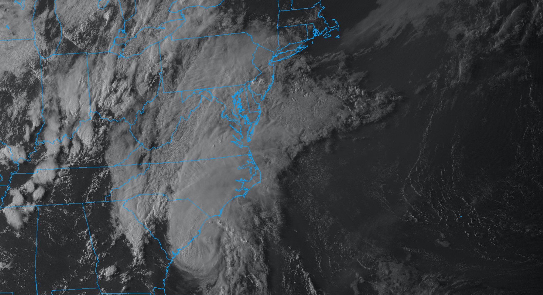
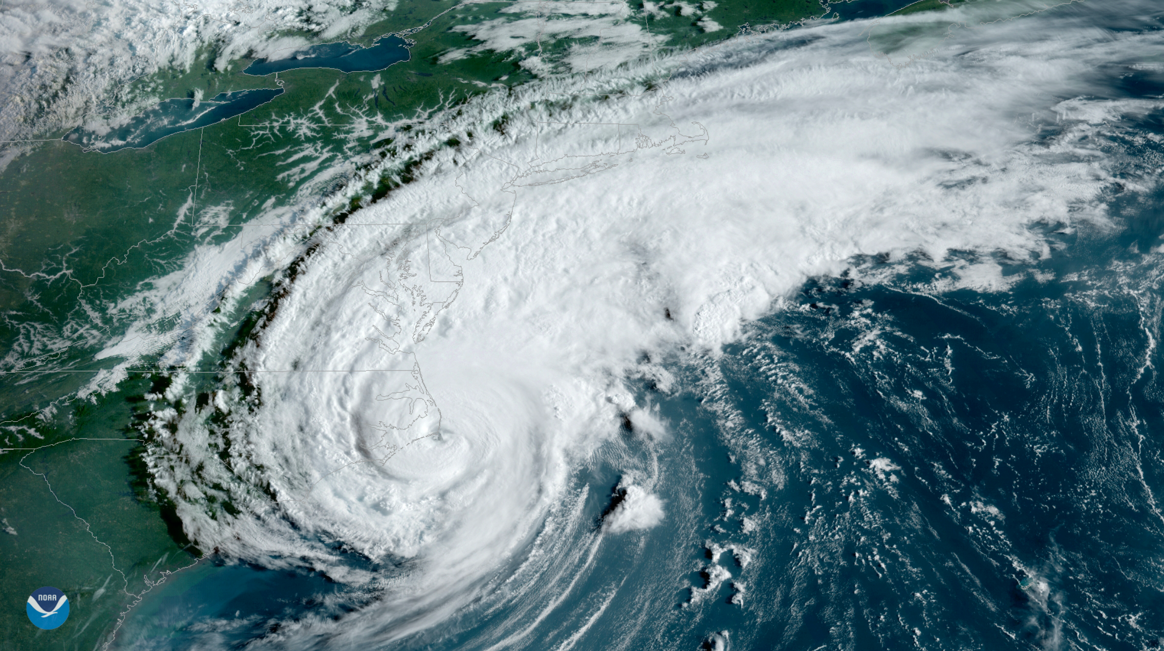
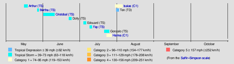
The Atlantic hurricane season got off to a fast start, with a handful of tropical cyclones impacting the United States. Hurricane Hanna and Tropical Storm Fay both impacted the states within the past several weeks. Most recently, Tropical Storm Isaias left a path of damage from the Carolinas to New England.
Despite the presence of a potential tropical cyclone as we speak, including Invest 95L in the Eastern Atlantic, the season is currently in the middle of a hiatus. While this system may develop into a Tropical Depression, prolonged strengthening is not anticipated. Conditions remain relatively unfavorable for tropical development and are expected to stay that way for a few more days.
In a week or so, atmospheric conditions will trend more favorable for tropical development. Multiple outlets, including Colorado State University and the National Hurricane Center, have recently upgraded their seasonal forecast numbers. Colorado State University notes that they are now expecting an “extremely active” season.
What exactly is going on?
Medium and long range model forecasting has improved significantly in the past decade. Meteorologists are now able to differentiate between ongoing global weather patterns, and often are able to pick out periods that will be more or less favorable for tropical cyclone development.
The Madden-Julien Oscillation, or MJO, is one major tool that meteorologists use frequently to forecast medium and long range weather patterns. The MJO is an eastward moving disturbance of clouds, rainfall, winds, and pressure that traverses the planet in the tropical latitudes and returns to its initial starting point in 30 to 60 days. Understanding the phases and amplitude of the MJO is important, as they can help dictate the weather throughout our hemisphere.
In the enhanced convective phases of the MJO, winds at the surface converge and air is pushed up throughout the atmosphere. At the top of the atmosphere, the winds reverse (i.e., diverge). Such rising air motion in the atmosphere tends to increase condensation and rainfall.
How the forecast will evolve
The strongest MJO event of the season is expected to move over the Eastern Pacific Ocean over the next week or two. This will support widespread convection across the basin, while the Atlantic remains somewhat dormant thanks to outflow-dominant, sinking air. Tropical storm and hurricane activity will increase across the Pacific over the next several days.

Within a weeks time, a convective-coupled Kelvin wave is forecast to traverse from the Pacific towards the Atlantic. Affectionately abbreviated as a CCKW, these atmospheric circulations are known for producing rising air behind them and sinking air ahead of them.
As this amplified MJO wave reaches the Atlantic Ocean, atmospheric conditions will become more conducive to the development of tropical cyclones. Major forecast models (including the ECMWF, CFS and GFS) are all in general agreement regarding this evolution.
Why timing is a concern
The forecast evolution of the MJO and likelihood of an active tropical period in the Atlantic is concerning enough in its own right. Making matters worse are the overall conditions throughout the Atlantic and Gulf of Mexico ahead of any development.
Sea surface temperatures are running well above normal throughout the Atlantic, specifically in key development regions as well as throughout the Caribbean (top 5 warmest on record). Wind shear remains very low (top 5 lowest on record). Africa seems primed to send disturbances into the tropics, currently experiencing a very wet weather pattern.
That’s right: As we head towards the climatological peak of hurricane season the oceans are record warm, wind shear is record low, and we are anticipating an MJO wave that will encourage the development of tropical systems.
Steve Copertino, a tropical expert at Empire Weather Consulting, noted his concern moving forward. “The combination of the favorable MJO, very warm sea surface temperatures, and a formidable African Easterly Jet will essentially act to lift the “lid” off the Atlantic basin”, he said when asked about the upcoming pattern. “It’s quite possible that we could see multiple formidable systems rolling off of Africa, and traversing the Atlantic during the end of August and into the beginning of September.”
Additionally, we’ve seen enhanced ridging parked over Atlantic Canada during the past two months which has acted to steer the majority of our systems west across the Atlantic without recurving out to sea. We’ll have to see if this pattern will remain in place for the upcoming active period as it could enhance the overall chances of tropical cyclone landfalls.
What to expect, and how to prepare
Our expectation is that hurricane activity will be active to very active, even when compared to August and September standards. The atmospheric ingredients discussed create a pile of overwhelming evidence that the remainder of this Atlantic hurricane season will be very busy.
While it is far too early to predict the track of these tropical storms, it’s safe to assume that impacts will occur in the Caribbean and United States at some point. If you live along the Gulf or Atlantic coastline, now is the time to prepare in advance for this period of potential activity.
Consider the medium range forecast a luxury; use this time to prepare and have a plan in place for when/if tropical systems actually threaten your location. There are a few key steps that can help you accomplish a solid plan:
- Know if you live in a heightened threat area (along the coast, near a river, etc)
- Research if you live in a flood plain or flood prone area
- Learn your coastal evacuation routes
- Create a hurricane kit or emergency kit with emergency supplies
Finally, there is no denying the fact that we remain in a global pandemic. Have a conversation with your family regarding coronavirus and a potential emergency.