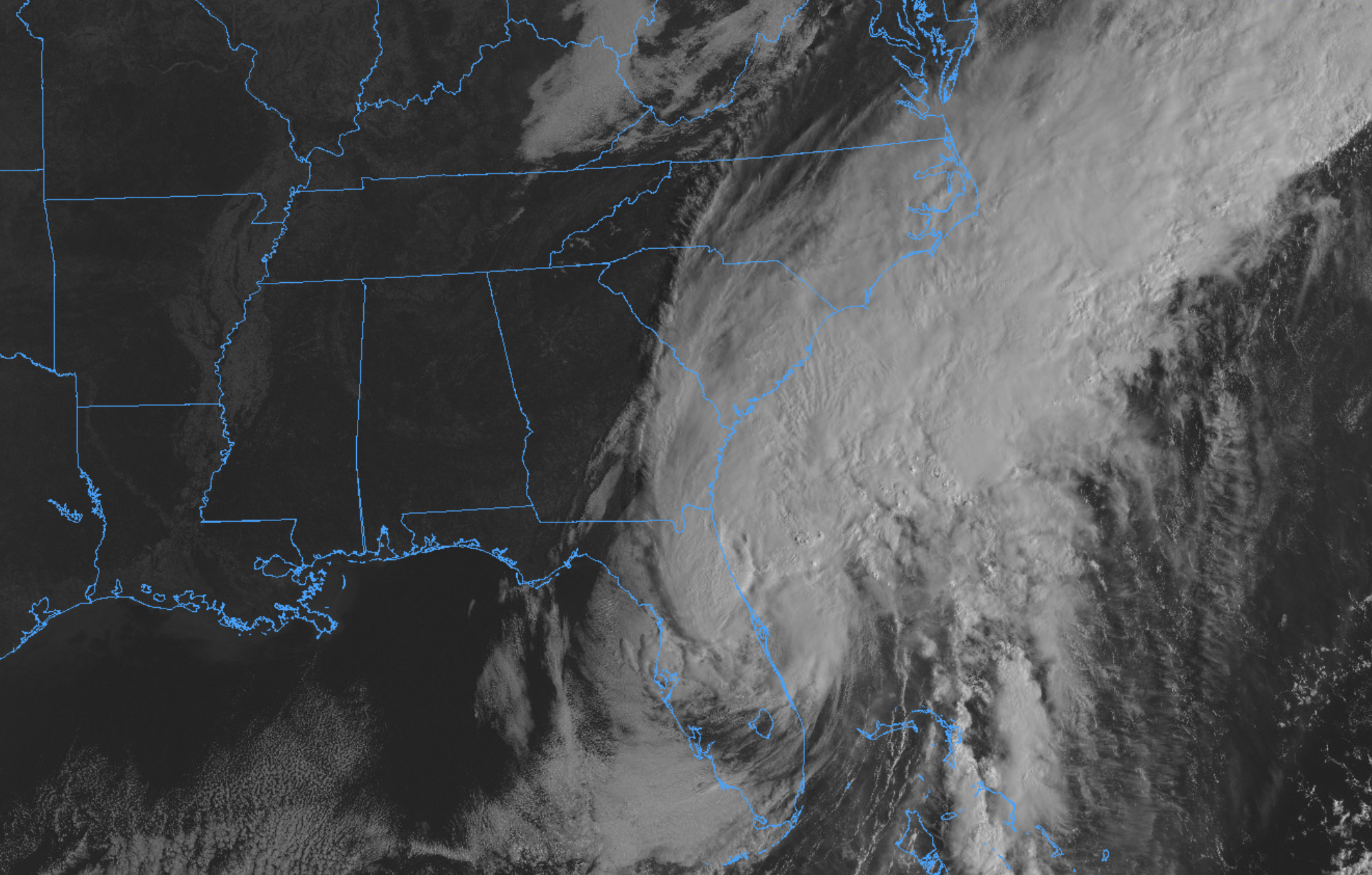
Hurricane Ian made landfall yesterday as a powerful Category 4 hurricane in Florida. The storm delivered catastrophic impacts to parts of the state yesterday including a dangerous storm surge, destructive winds and flooding rains. The threat for dangerous conditions will likely persist well today as the storm crosses the state, despite weakening.
https://www.nymetroweather.com/wp-content/uploads/2022/09/Screen-Shot-2022-09-29-at-8.20.20-AM.png13302084John Homenukhttps://www.nymetroweather.com/wp-content/uploads/2024/02/Empire-2000-x-300-px-2.pngJohn Homenuk2022-09-29 09:23:102022-09-29 13:38:21When will the remnants of Ian reach NYC?
At long last, the oppressive heat and humidity has left the party. Temperatures and dew points will trend into a much more comfortable range from tomorrow into the weekend.
In fact, most model guidance suggests that both Friday and Saturday could be top-tier weather days in the NYC Metro Area, with temperatures in the lower to middle 80’s and dew points in the 50’s. That’s about as good as it gets for summertime around here.
The pleasant weather is very likely to continue into Sunday, with the weekend overall turning out to be one of the nicest in quite some time. By midday Sunday, we’ll start to see an increase in high and mid level clouds. That’ll be a harbinger of unsettled weather to come during the early and middle part of next week.
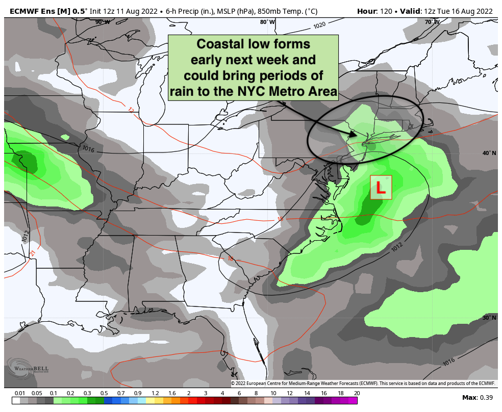
Guidance suggests that a trough will form over the Eastern United States early next week, drawing moisture back into the area and encouraging the development of a low pressure system off the coast. Exactly where this storm tracks remains a bit of an uncertainty right now.
Some guidance keeps the storm very close to the coast with multiple days of showers and rainy weather. Other models keep the storm more progressive, allowing to to escape out to sea faster and bringing just a brief period of showers before conditions clear out.
The current expectation is that we’ll have at least somewhat unsettled conditions from Monday into Wednesday. If the storm tracks close to the coast, periods of heavier rain will be possible (which honestly wouldn’t be a terrible thing given the localized drought conditions). If it moves out to sea faster, we’ll likely still see unsettled conditions on Monday – but a faster improvement on Tuesday and Wednesday.
As always, we’ll have updates and the latest information on what to expect as we get closer. Stay tuned to our socials and make sure to pop any questions you may have regarding the forecast right here in our comments section!
https://www.nymetroweather.com/wp-content/uploads/2020/08/wojtek-witkowski-GtxZbYMCiPY-unsplash-scaled.jpg17002560John Homenukhttps://www.nymetroweather.com/wp-content/uploads/2024/02/Empire-2000-x-300-px-2.pngJohn Homenuk2022-08-11 21:30:332022-08-11 21:30:36Beautiful weather this weekend, coastal storm next week?
The weather on Independence Day weekend is always a point of contention. It is humidity and thunderstorm season after all – and on a weekend when almost everybody will be spending lots of time outside, the weather forecast can be very tricky. This year is no different, with transitional weather conditions anticipated.
Warm and humid weather on Friday will give way to pleasant, sunny and less humid weather on Sunday and Monday. The 24-hour period from Friday evening through Saturday evening appears the most precarious, with showers and storms are likely. Some of them may be severe on Saturday afternoon. Here’s the deal:
https://www.nymetroweather.com/wp-content/uploads/2022/06/varun-agarwal-yYJoXXRNUS8-unsplash-scaled.jpg19202560John Homenukhttps://www.nymetroweather.com/wp-content/uploads/2024/02/Empire-2000-x-300-px-2.pngJohn Homenuk2022-06-30 19:18:202022-06-30 19:18:22NYC Fourth of July Forecast: Great summer weekend with one exception
Good morning, NYC! The humidity has returned today, and it signals increasing moisture and instability in the atmosphere. This will eventually lead to the potential for showers and thunderstorms later this afternoon. Some of the storms are expected to be severe, with the potential for strong wind gusts and a few isolated tornadoes. Scattered storms are also anticipated on Saturday before conditions dramatically improve on Sunday and Monday.
Hi friends! Our website uses cookies to provide an optimal browsing experience for you. New "Cookie Consent" laws mandate us to inform you of this. As long as you're cool with it, just hit OK. You'll only see this message once.
We may request cookies to be set on your device. We use cookies to let us know when you visit our websites, how you interact with us, to enrich your user experience, and to customize your relationship with our website.
Click on the different category headings to find out more. You can also change some of your preferences. Note that blocking some types of cookies may impact your experience on our websites and the services we are able to offer.
Essential Website Cookies
These cookies are strictly necessary to provide you with services available through our website and to use some of its features.
Because these cookies are strictly necessary to deliver the website, refusing them will have impact how our site functions. You always can block or delete cookies by changing your browser settings and force blocking all cookies on this website. But this will always prompt you to accept/refuse cookies when revisiting our site.
We fully respect if you want to refuse cookies but to avoid asking you again and again kindly allow us to store a cookie for that. You are free to opt out any time or opt in for other cookies to get a better experience. If you refuse cookies we will remove all set cookies in our domain.
We provide you with a list of stored cookies on your computer in our domain so you can check what we stored. Due to security reasons we are not able to show or modify cookies from other domains. You can check these in your browser security settings.
Other external services
We also use different external services like Google Webfonts, Google Maps, and external Video providers. Since these providers may collect personal data like your IP address we allow you to block them here. Please be aware that this might heavily reduce the functionality and appearance of our site. Changes will take effect once you reload the page.
-2")