Winter weather expected in the NYC Area early next week

The Winter of 2020-2021 has been very quiet in terms of winter weather thus far, as expected. The winter storm which brought nearly 10″ of snow to NYC on December 15th seems like a distant memory at this point, as warm temperatures and below normal precipitation have taken over since. This will change next week, with a winter storm expected to impact the area later Monday and Tuesday.

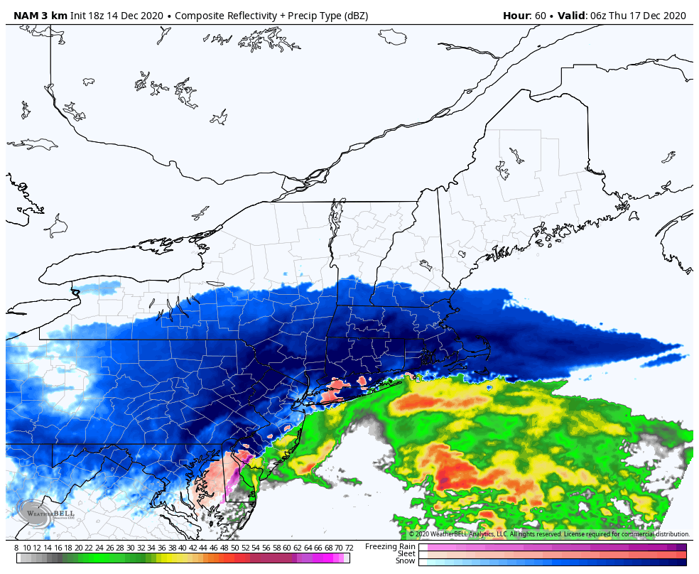
A low pressure system is expected to develop into the Ohio Valley on Monday morning, and then redevelop off the coast of the Mid-Atlantic states by Monday evening and Tuesday morning. Wintry precipitation will spread into the Northeast states as a result, with bands of snow impacting the region through midday Tuesday. By the time all is said and done, light to moderate snow accumulations appear possible.

What’s causing the potential for snow?

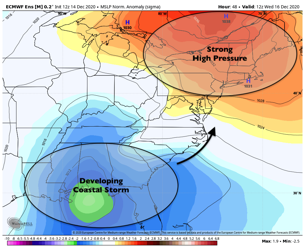
This particular winter storm threat is originating from a disturbance in the Southwest United States. The disturbance will eject out of the Four Corners region, traverse through the Mississippi River Valley, and then move towards the Northeast states early next week. While the system may have a tendency to amplify and would normally try to move west of the area, a strong blocking high pressure near Greenland will force it to redevelop off the coast.

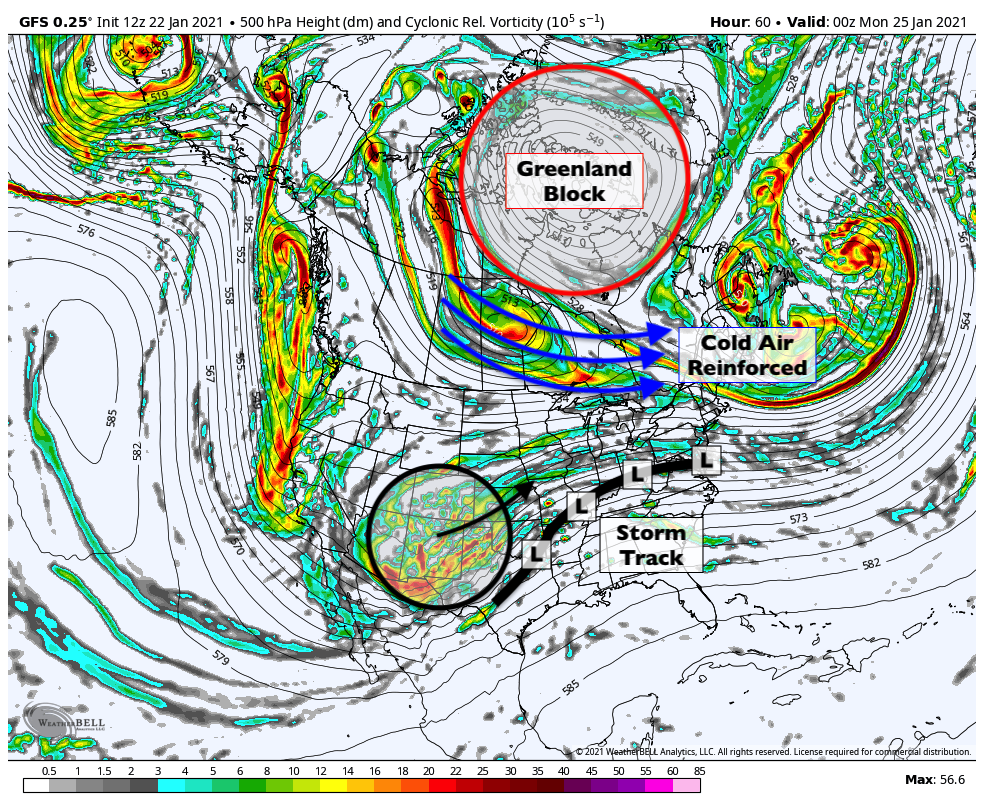
Greenland blocks are effective at blocking atmospheric “traffic”. These large, anomalous areas of high pressure send cold air southward into Canada from the Arctic, but also stop warm air from advancing very far northward into the Northeast states. Instead, storms are often forced to redevelop off the coast, leading to more wintry scenarios for the NYC Area. Greenland blocks are, for this reason, notorious predecessors to wintry weather patterns in our area.

As a low pressure system moves into the Ohio Valley, it will start to feel the effects of the traffic “block” ahead of it. A confluent atmospheric flow will help force the redevelopment of the storm as a coastal low off the Mid-Atlantic coast on Tuesday morning. The system is then expected to pull away from the area later Tuesday.

What uncertainties still exist regarding this storm?

While we are confident that the storm will redevelop to our south, leading to wintry precipitation, we’re far less certain regarding exactly how precipitation will behave as it traverses the area. As the storm redevelops, it will begin to meet increasing resistance from dry air to our north. The dynamics of the system will begin to wane and oscillate. This won’t be a particularly strong storm.

As a result, bands of snow will be more unpredictable than usual. It is still uncertain just how far north the best moisture – and resulting snow – will get. Forecast models are still at odds regarding just how heavy precipitation will be, too. There is still quite a bit to suss out over the next few days.

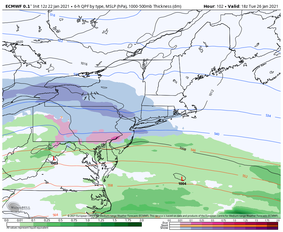
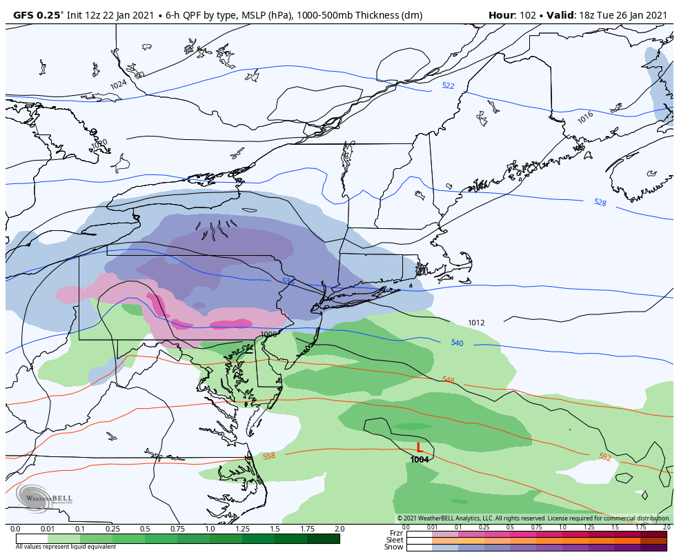
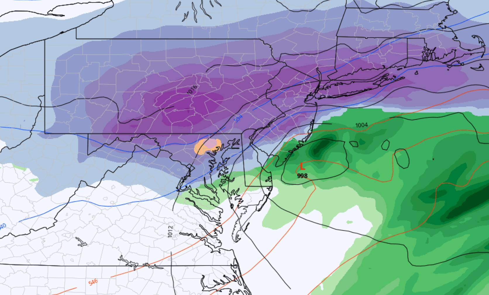
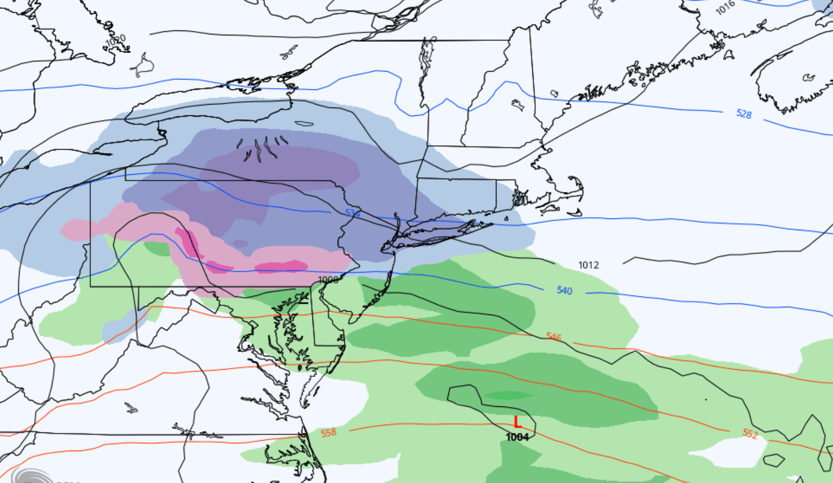
The ECMWF model (pictured above and left), for example, has recently trended lighter with precipitation totals. It suggests light and sporadic precipitation, with snowfall amounts generally near 2-3″ in the NYC Area. The GFS (above right), and some other guidance are a bit more bullish with precipitation totals and dynamics, leading to snowfall totals closer to 4-5″.

Our forecast currently lies somewhere in between, with moderate (40-70%) confidence in at least 3″ of snowfall in the NYC Metro area. Confidence is slightly higher (70-90%) further west in parts of Pennsylvania, where atmospheric dynamics are expected to be more favorable for steady and heavy snowfall.

What are the anticipated impacts and timing?

This is not expected to be an overly intense winter storm. Snow should begin during the late afternoon or evening hours on Monday, and is expected to continue into the overnight hours and through Tuesday morning. Snowfall rates should oscillate between light to moderate for the majority of the time, with some bursts of heavier snow possible.

Light to moderate snowfall should continue through Tuesday morning, tapering off slowly through the afternoon. Given the light to moderate snowfall intensity and anticipated snowfall totals, this is expected to be a low to moderate impact event for the majority of the NYC Metro Area. This means that travel and commute impacts are possible, but are mostly expected to be manageable.

Stay tuned over the weekend, as we anticipate the forecast will become more clear. This will give us the ability to hone in on details and provide further context on what to expect in terms of sensible weather impacts.

Major winter storm expected in NYC from Wednesday into Thursday

A significant winter storm will impact the NYC area later this week, with heavy snowfall expected from Wednesday afternoon into Thursday. Significant accumulating snow plus strong, gusty winds will lead to hazardous travel conditions. Isolated power outages are also possible. As a result, the National Weather Service has issued a Winter Storm Watch for the NYC Metro Area and surrounding parts of NJ and CT from late Wednesday into Thursday.

The disturbance which will eventually produce the winter storm in the NYC Metro Area is already in the United States currently traversing the four corners of the Southwest US. This disturbance will move eastward over the next day or so, through the Central United States and eventually towards the Mississippi Valley. As it does so, it will begin to amplify and strengthen.

Meanwhile, a strong high pressure system will begin to develop across Southeast Canada and Northern New England. This high pressure system will funnel cold air southward from Canada into New England and the NYC Metro Area from later Tuesday into Wednesday. As the aforementioned disturbance begins to amplify up the east coast, it will begin to encounter resistance from the cold air and high pressure to its north.

This evolution will set the stage for a significant winter storm throughout the Northeast states, as an an amplifying disturbance encounters a cold high pressure system. Snow will spread throughout the Northeast states on Wednesday afternoon and evening, and the storm will continue through Thursday. The gradient between the developing low pressure and strong high pressure to its north will lead to an enhanced risk of strong wind gusts as well.

When all is said and done, significant snowfall totals are expected and blizzard conditions are possible. This will likely be an impactful winter storm with a broad area of hazardous weather, including the potential for difficult or impossible travel and isolated to scattered power outages.

Anticipated timing and impacts

The storm is expected to move in to the NYC Area relatively quickly on Wednesday afternoon and evening, with snow becoming heavy quickly after it begins. This will lead to the potential for rapidly developing travel difficulties. Here’s how we expect the event to shake down in Northern NJ and NYC:

Wednesday Evening (6:00pm – 9:00pm): Snow begins quickly from west to east. Snowfall rates could become heavy rather quickly with accumulations on all surfaces.

Wednesday Evening (9:00pm – 12:00am): Very heavy snow is likely during this time with periods of near whiteout conditions. Gusty north/northeast winds are also anticipated.

Thursday Early Morning (12:00am – 3:00am): Moderate to heavy snow continues. A period of sleet is also possible during this time, especially along the south shore of Long Island including parts of Brooklyn and Queens. Travel will remain difficult with strong winds and moderate to heavy snowfall

Thursday Morning (3:00am – 6:00am): Light to moderate snowfall will linger but begin to wane in intensity from west to east. Travel will remain extremely difficult and strong winds will lead to blowing and drifting of snow. Snow may persist into late morning or perhaps even the afternoon, but will become much lighter by that time.

Forecast and uncertainties

Our current forecast calls for 8 to 12 inches of snow in the greater NYC Metro area. As is often the case, the expectation is for higher amounts just to the northwest of the city and lesser amounts to the southeast and closer to the coast. In this particular case, the snowfall gradient could be quite dramatic especially across parts of Central New Jersey.

The main uncertainty in regards to this storm is how far north and west the low pressure area tracks. Forecast model guidance has waffled over the past few days regarding the placement of the storm as it moves to a position near the New Jersey coast. A stronger storm, tucked in closer to the shoreline, could lead to a warmer overall solution with slightly less snowfall in the NYC Metro area. A slightly weaker storm, tracking slightly further off the coastline, would generally lead to a more wintry outcome.

Ensemble data remains split on exactly where the system will track – and accordingly, the forecast is only of moderate confidence. The range of anticipated snowfall in the NYC metro area remains 8 to 12 inches, but ensemble data range on the outer periphery expands from 4 inches to nearly 18 inches.

Over the next 24 hours, the track of the system should become more clear. This will allow us to become more confident in where bands of heavy snow will set up, and the storm total snowfall forecast map is likely to be tweaked and adjusted during that time.

NYC Forecast: Anomalously warm pattern settles in

Temperatures soared into the 70’s in the NYC Area on Friday as an anomalously warm pattern settled in to the Eastern United States. The warmth is expected to continue for the next several days, as a large ridge of high pressure dominates the weather pattern in our area. High temperatures could reach the lower 70’s each day through early next week.

Read more

Weekly Forecast: Cold start, trending much warmer

Anomalous cold and strong winds have highlighted the forecast today, but they won’t be here for long. As the week goes on, temperatures will trend above normal. Later this week and weekend, temperatures could reach as much as 20 degrees above normal, with high temperatures near 70 degrees in the NYC Metro.

Read more