After battling through a few weeks of colder than normal weather, we have now made the jump straight to high humidity and warmth. How exciting! In all seriousness, summer-like weather is, at least for the time being, here to stay. Temperatures today will approach the 80’s and humidity levels will once again be sky-high with rising dew points and atmospheric moisture content.
https://www.nymetroweather.com/wp-content/uploads/2020/05/Screen-Shot-2020-05-29-at-12.19.17-PM.png12962256John Homenukhttps://www.nymetroweather.com/wp-content/uploads/2024/02/Empire-2000-x-300-px-2.pngJohn Homenuk2020-05-29 12:22:212020-05-29 12:22:27Showers and storms expected this evening, unsettled pattern to continue
Showery and drizzly weather over the past 24 hours has been the sign of an incoming storm system. A warm front is lifting slowly northward through the Mid-Atlantic states this evening, and will make its way through NYC during the morning hours on Friday. Warm air (thanks, southwest winds!) will then come surging in. Here’s how the forecast will shake down over the next few days:
https://www.nymetroweather.com/wp-content/uploads/2020/03/ian-dooley-1ZeONWWG_H4-unsplash-scaled.jpg17082560John Homenukhttps://www.nymetroweather.com/wp-content/uploads/2024/02/Empire-2000-x-300-px-2.pngJohn Homenuk2020-03-19 20:26:312020-03-19 20:36:34Warmth, storms on Friday will be followed by colder weather
The active weather pattern is expected to continue in the Northeast this week. Temperatures will fluctuate quite a bit, and a few rounds of showers are likely. Here’s the breakdown over the next few days
Monday through Wednesday
The week will start off quiet enough, but temperatures will remain quite cool. Highs are expected to reach only into the middle to upper 40’s on Monday, as a cooler airmass temporarily swings by. Clouds will increase later in the day.
Showers are expected by Monday evening and could continue into Tuesday as a disturbance passes by. Moisture isn’t overly impressive, but there will be enough lift in the atmosphere for showery conditions. We aren’t expecting any areas of heavy rainfall. Temperatures on Tuesday will be noticeably warmer, in the middle to upper 50’s.
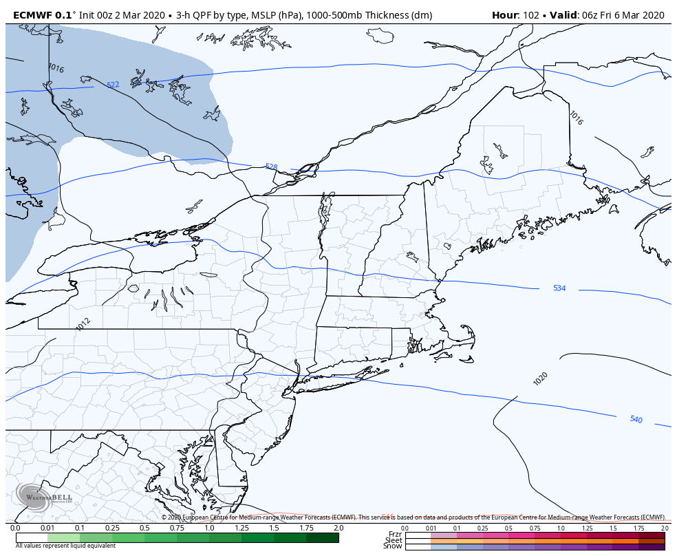
Forecast rainfall amounts through Thursday evening on the ECMWF Model.
The nicest day of the week by far looks to be Wednesday. Temperatures will reach into the mid 50’s with lots of sunshine anticipated behind the aforementioned disturbance.
Thursday through Sunday
The weather pattern will take an unsettled turn again later in the week. A storm system ejecting into the Plains states will send moisture surging northward, with a disturbance reaching the Ohio Valley. Expect periods of showers as soon as late Wednesday evening.
Some periods of heavy rain are possible on Thursday as the low pressure center passes near our area. Showery conditions will likely persist well into Friday as the main surface low then moves into the Great Lakes.
High temperatures on Friday will reach past 70 degrees in many locations.
Temperatures will trend much warmer by Friday, with highs possibly reaching into the 70’s. Showers and clouds are likely to be around, but it will certainly feel like Spring.
The system clears out of the area by Saturday with cooler temperatures returning again. The roller coaster of temperatures is fairly common for Spring, but will be accentuated by a few storm systems this week.
We’ll have further updates on the pattern as it evolves over the next few days.
https://www.nymetroweather.com/wp-content/uploads/2020/03/sherzod-max-129EQ55LQHA-unsplash-1-scaled.jpg17072560John Homenukhttps://www.nymetroweather.com/wp-content/uploads/2024/02/Empire-2000-x-300-px-2.pngJohn Homenuk2020-03-15 19:16:152020-03-15 19:16:28Active weather pattern to continue this week
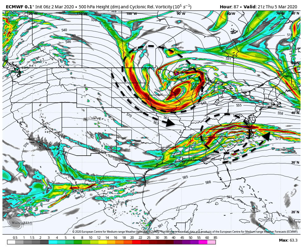
Forecast model and ensemble guidance continues to suggest that a strong coastal storm will develop later this week. A disturbance diving southward from Canada is the main culprit, as it interacts with a secondary disturbance near the US East Coast. The exact timing and details of the disturbances evolution will go a long way towards determining impacts in the Northeast US.
While not currently anticipated, winter weather could become a possibility with this system. This would be especially true if the coastal storm is able to rapidly strengthen near or south of our latitude.
Breaking down the setup
Two disturbances at 500hPa could interact later this week, leading to a coastal storm
As is the case with most coastal storms, the setup is quite intricate. There are a few key components:
A disturbance moving eastwards from Texas into Dixie Alley and then towards the Mid Atlantic Coast
Another disturbance diving southward from Canada into the Great Lakes and eventually Northeast States
A large ridge in the Western United States
Ensemble guidance strongly suggests that the disturbance over the Great Lakes region (Disturbance No. 2 above) will drive southeastwards. This will allow it the opportunity to interact with, or potentially phase with, the disturbance over the Mid Atlantic coast (Disturbance No. 1 above).
The result of this interaction and amplification could be the development of a strong coastal storm. As you might imagine, the exact details of how these two features interact will have huge implications on the coastal storm that develops and the resulting forecast.
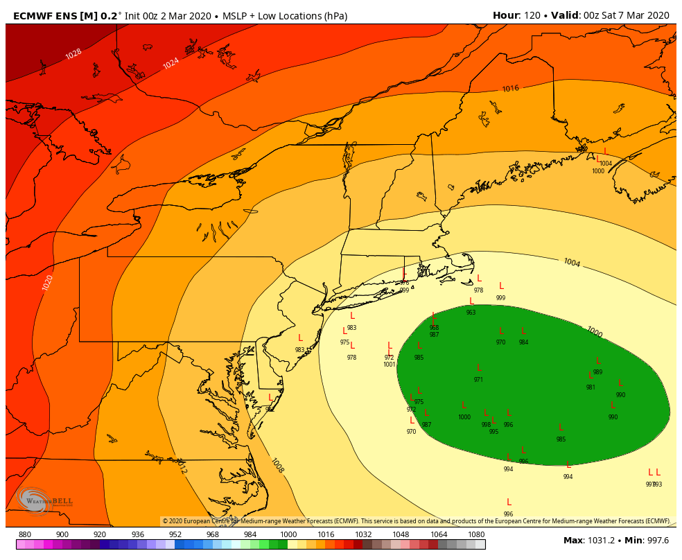
ECMWF Ensemble members showing several very strong coastal storms
At the moment, ensembles are in unusually strong agreement that a notable coastal storm will develop. The exact track of the system is uncertain, but the signal is strong for this range (3-5 days) with almost all ensemble members indicating a storm of some sort.
Potential impacts in our area
A myriad of impacts are possible throughout the Northeast states from this system, including but not limited to significant snowfall, snow squalls, coastal flooding, and strong wind gusts. Exactly how the system evolves will have a huge impact on the weather observed in our area.
At the moment, the storm looks likely to rapidly strengthen just – and we cannot stress this enough, just – far enough east for the NYC Metro area to avoid significant impacts. Still, even with the current thinking, the potential for snow squalls and blustery winds will exist.
The potential exists for a late season winter storm with this system, particularly in parts of New England. The further south/west the storm tracks, and the faster it strengthens, the more widespread wintry weather impacts could be – even in our area. The further east or more progressive it remains, the less likely impacts will be.
Stay tuned over the next few days for more details, and be sure to follow along on our social media accounts for more updates on the potential storm system.
https://www.nymetroweather.com/wp-content/uploads/2020/03/valou-_c-U7ExImpZMME-unsplash-scaled.jpg17072560John Homenukhttps://www.nymetroweather.com/wp-content/uploads/2024/02/Empire-2000-x-300-px-2.pngJohn Homenuk2020-03-02 08:01:392020-03-02 08:01:50Strong coastal storm possible later this week
Hi friends! Our website uses cookies to provide an optimal browsing experience for you. New "Cookie Consent" laws mandate us to inform you of this. As long as you're cool with it, just hit OK. You'll only see this message once.
We may request cookies to be set on your device. We use cookies to let us know when you visit our websites, how you interact with us, to enrich your user experience, and to customize your relationship with our website.
Click on the different category headings to find out more. You can also change some of your preferences. Note that blocking some types of cookies may impact your experience on our websites and the services we are able to offer.
Essential Website Cookies
These cookies are strictly necessary to provide you with services available through our website and to use some of its features.
Because these cookies are strictly necessary to deliver the website, refusing them will have impact how our site functions. You always can block or delete cookies by changing your browser settings and force blocking all cookies on this website. But this will always prompt you to accept/refuse cookies when revisiting our site.
We fully respect if you want to refuse cookies but to avoid asking you again and again kindly allow us to store a cookie for that. You are free to opt out any time or opt in for other cookies to get a better experience. If you refuse cookies we will remove all set cookies in our domain.
We provide you with a list of stored cookies on your computer in our domain so you can check what we stored. Due to security reasons we are not able to show or modify cookies from other domains. You can check these in your browser security settings.
Other external services
We also use different external services like Google Webfonts, Google Maps, and external Video providers. Since these providers may collect personal data like your IP address we allow you to block them here. Please be aware that this might heavily reduce the functionality and appearance of our site. Changes will take effect once you reload the page.
-2")