Mid to Late February Pattern Relaxation…But is That It?

The winter regime that has been dominant since November will be breaking down over the course of the next 5 to 7 days. However, does that mean winter is ending? I will be providing evidence to the contrary in this discussion. First, let’s not ignore the storm threat immediately in front of us. After a period of light snow later today (on the order of coating to 1″ amounts for most), most of the models are signaling the potential of a phased system Wed-Thurs along the east coast. The mid level energy associated with it is quite potent, but the lack of downstream NAO blocking could be problematic in terms of precipitation type for our area. Nevertheless, there is a signal for a strong surface low riding SW-NE near the coast mid/late week. Whether the precipitation falls as snow, mostly snow, rain to snow, or rain, is uncertain at this juncture. As always, the track of the low is crucial. Polar air will be rapidly retreating mid week, after another shot of bitter chill arrives Mon-Tues, with overnight lows Wednesday morning probably widespread in the single digits across suburbia. Snowpack and clear, calm conditions will aid the temperature plummet. Beyond mid week, the airmass becomes “stale” cold, and our Wed-Thurs system must intensify such that it can cool the lower boundary layer dynamically. A weak low is not going to produce accumulations in the mid week pattern. We need a strong storm to our east. There’s time to work on this situation, but let’s move along to the pattern thereafter.

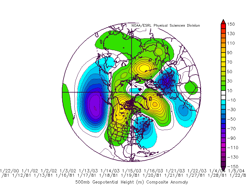
This has been the 500mb / mid level pattern since December 1st. As anticipated the negative EPO / NPAC high pressure feature has been the mainstay of the winter, providing a funneling mechanism for Siberian cold into North America. The NAO has been predominately positive, and the AO, though strongly positive in December, has been closer to neutral values for the heart of the winter.


dectofeb2014

Read more

End of Month Storm Threat Could Precede Active February Pattern…

Old man winter has returned in a big way over the past week, complete with severe cold, bitter wind chills, and significant snow across much of the Northeastern US. Our brief January thaw has transitioned into a highly amplified, meridional pattern, as the EPO continues strongly negative. This north Pacific / Alaskan block has been a mainstay of winter 2013-14, and if one examines the SSTA profile in the Pacific, ocean temperature anomalies persist well above normal south of Alaska. Thus, the signaling remains for a positive feedback cycle of building the mid level ridge over Alaska, and maintaining the cross polar flow from Siberia/Arctic into Canada.

There are indications that some of the global indices will undergo a significant change mid/late next week, and this should play a large role in the end of January storm thread which will be discussed here. Prior to that potential, we have a light snow accumulation event coming Saturday, the 25th, with potentially (as it stands now) another light accumulation early next week. The threat for a more moisture laden, Miller A storm exists beyond the middle of next week, particularly in the January 27th-February 2nd. Let’s put together the meteorological pieces for why this potential does in fact exist.

Tropical forcing has recently awakened as the latest MJO wave is progged by most model guidance to progress through phase 7. MJO phase 7 in January generally argues for the development / persistence of -EPO blocking, PNA ridging, and Arctic/NAO blocking as well. MJO phases 7, 8, and 1 are the most conducive for sub tropical jet activation and so I wouldn’t be surprised to see models beginning to detect a stronger southern stream short wave for later next week. So far this winter, the dominant snow producer has been northern stream Miller B type short waves. These are systems which can provide significant to major snows given the surrounding synoptics are favorable for tilting and deepening near the east coast. Miller A type storms, however, originating in the sub tropical jet stream, often are moisture laden and bigger snow makers.

Below is the MJO phase 7 500mb composite. Notice the ridging in the West, across the arctic, and in the NAO regions.

JanuaryPhase7500mb

Read more

Transition to colder, snowier pattern becoming likely

Forecast models in the medium to long range,continue to show a pattern change throughout the northern hemisphere — characterized by a west coast ridge and a large, anomalous trough in the Eastern United States. This has been mentioned several times over the last week as our forecasters have suggested the pattern change by the end of January. Exactly how the pattern plays out remains a mystery at this juncture, especially as some continue to overanalyze and interpret operational model guidance — which is never smart. The individual nuances of the pattern are going to take days to iron out.

The first development of note is that the ECMWF has finally caved to the GFS and GEFS interpretation of tropical forcing which will increase later this week and help the development of some major pattern changes. The ECMWF had previously been very stubborn in insisting against this development and keeping the impulse quite week. This cave is very important for the eventual changes in the Pacific including the development of a +PNA regime (i.e the west coast ridge).

MJO forecast from the ECMWF model.

MJO forecast from the ECMWF model.

Read more

Mid January thaw a transient interruption in the pattern

The pattern over recent weeks has proven to be an interesting one across the majority of the United States, as the record cold temperatures and plentiful snow has visited folks from the Mid-west, Great Lakes, and the Northeast. Our significant snowstorm last week was due in large part to the negative EPO / positive PNA regime in concert with a well-timed Greenland block, allowing short wave amplification to occur on the mid atlantic coast. Since that time, the Greenland block has dissipated, and the western ridge will collapse in a few days, not before a near record / record cold airmass arrives Monday night.

(Log in to view this post, or purchase it for $.99 !)

[s2Member-PayPal-Button sp=”1″ ids=”4153″ exp=”72″ desc=”View this Premium Long Range Post for only $.99!” ps=”paypal” lc=”” cc=”USD” dg=”0″ ns=”1″ custom=”www.nymetroweather.com” ra=”0.99″ image=”default” output=”button” /]

Read more