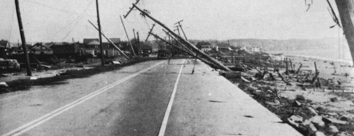
76 years ago, Category 3 hurricane slammed Long Island

For anybody who lives on Long Island or in New England, the Great Hurricane of 1938 will forever be remembered as the “worst of the worst”. Killing hundreds of people, destroying 57,000 homes and totaling $306 million in damages (~40B in 2014), the storm was the strongest and costliest storm to ever strike Long Island and New England. Damage from the storm, on trees and buildings, was still visible in the early to mid 1950’s, almost 20 years after the storm made landfall.

The storm’s origins can be tracked back to ship data from the Eastern Atlantic ocean, where the storm was first observed near the Cape Verde Islands on September 9th, 1938. The storm then, presumably, tracked west-northwestward while organizing. Data is sparse, but not incomplete — the storm reemerges in more dense data near the Bahamas on September 20th, 1938. At this point, the storm is estimated to have attained Category 5 status — with maximum sustained winds over 140 miles per hour. But it was here that the trouble began, for those in the Northeastern United States. The storm would never actually strike the Bahamas. Instead, it would begin veering to the north, on the periphery of a trough to its east.

Read more

NOAA announces Summer 2014 was warmest ever on Earth

2014 has been officially announced as the warmest summer on Earth, since records began in 1880. The newest climate report published by the National Climate Data Center at NOAA released the information today as well as other in-depth information from around the world for this summer and its individual months. In addition to the summer as a whole being the warmest on record, August 2014 was also the warmest August ever recorded on Earth, finishing 0.75 degrees Celsius above the 20th century average.

While the summer in our area was relatively average, if not cool, the ocean waters throughout the globe and different land areas worldwide led to the wildly above-average temperatures. The summer as a whole finished 0.71 degrees Celsius above the 20th century average. The ocean temperatures set a record high anomaly for all months.

Read more

One year ago today: A storm chase to remember

Last spring, between May 22-30, a few of my storm chasing buddies and I went storm chasing in the Great Plains. Exactly one year ago today, we saw an EF4 wedge tornado in Bennington, Kansas. The sights we saw last year were unbelievable, and I figured I would share some of my favorite shots from last year’s trip. All of the photos posted are from myself and Jenny Kafka. For more of Jenny’s photos, you can visit jennykafta.com.

May 25, 2013 — South Dakota.

May 25, 2014. (Doug Simonian)

May 25, 2013. (Doug Simonian)

May 25, 2013. (Doug Simonian)

May 25, 2013. (Doug Simonian)

May 25, 2013. (Jenny Kafka) For more of Jenny's photos, you can visit jennykafka.com.

May 25, 2013. (Jenny Kafka) For more of Jenny’s photos, you can visit jennykafta.com

May 25, 2013. (Jenny Kafka)

May 25, 2013. (Jenny Kafka)

Read more

What causes storms to strengthen?

In light of Wednesday’s meteorological bomb of a storm that was just offshore, we have decided to write an article that explains why storms strengthen to begin with, and how they can get to be as strong as this storm got. Wednesday’s storm went under what we call “bombogenesis” (yes, that is a real meteorological term), meaning that its pressures dropped more than 24 millibars in 24 hours. At once point, surface analysis showed the storm being as strong as 955mb, which is equivalent to a category 3 hurricane!

As most of you probably know, a lower pressure means a stronger storm, and a higher pressure means a weaker storm — or if the pressure is high enough, an area of tranquil weather. Now the question becomes, what causes pressures to fall in a certain area, and why do they sometimes fall so rapidly?

The most important meteorological aspect for pressure falls is an area of upward vertical motion. If air is being lifted vertically, then pressure within that column of air has to decrease, because air is escaping that column when it is moving vertically. Naturally, if less air exists within a column, the pressure in that column will be less.

The atmosphere always wants to maintain balance, so to accommodate for the air that is being lifted vertically, there is a need for air to converge at the surface to replace what is lost at the surface, and to generate the lift to fill the void in that column of air as well. This is one reason why air converges at the surface in areas of lower pressures; it is all part of the balancing act of the atmosphere. Air also flows from higher pressures to lower pressures, being that lower pressures are an area of least resistance; another aspect of this balancing act. All areas of relatively higher pressures essentially shove air away, and it all converges where the lowest pressure is. This surface convergence leads to upward vertical motion, which leads to storm development, precipitation, and an additional lowering of pressure.

To illustrate this further, think about the opposite scenario: wouldn’t it make sense for pressure at the surface to be higher if there were downward vertical motion, meaning that air is being pressed downward towards the ground?

A water vapor animation taken yesterday afternoon, beautifully illustrates the size and strength of the storm system (wx.rutgers.edu).

A water vapor animation taken Wednesday afternoon, beautifully illustrates the size and strength of the storm system (wx.rutgers.edu). You may need to click to animate.

Let’s go over the factors that cause upward vertical motion:

Read more