-2")
Potentially Record-Breaking Warmth and Unsettled Conditions Take Hold Over the East
Good evening!
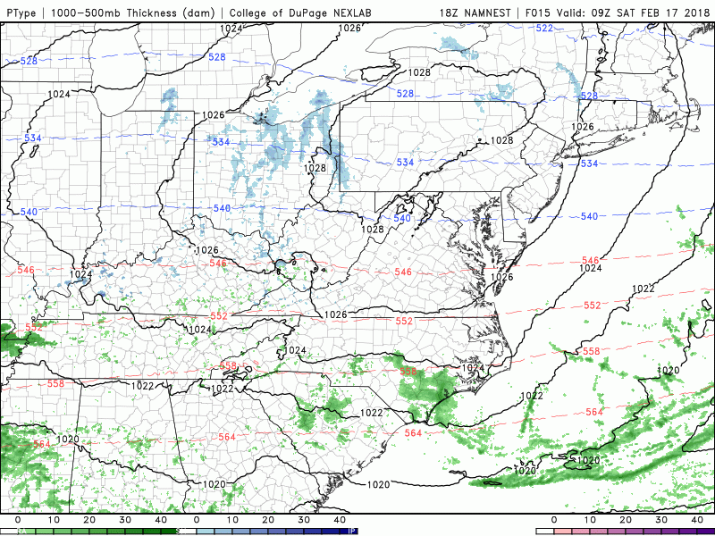
It certainly has been a wild swing of events over the past week or so, with above normal temperatures, a snowstorm, and now the potential for some record breaking warm weather later this week! This will likely be a gradual process, with the first major changes taking place during this afternoon and evening. A very large upper level trough out in the western half of the country is currently digging into southwest, allowing for a very large mid level ridge to build over the east. This large mid level trough has also spawned a weak, but expansive low pressure system over the Plains today, with numerous showers and thunderstorms extending from the deep south, into the Ohio Valley and Northeast. This large low pressure system has sent moisture north into the region which has been collecting along a mid level frontal system. This mid level front has been responsible for areas of steady rain over portions of New England, with more patchy rain to the south over Pennsylvania, New Jersey, New York, and Connecticut. This area of rain should continue to lift north with the frontal system through the overnight hours, leaving spotty drizzle and cloudy conditions behind. Mid level temperatures will be rising quite a bit this evening as high pressure to our south sends a stout southwesterly flow over the East. This will ensure that conditions stay rather cloudy with much above-normal temperatures this evening. In fact, lows may not drop at all for most of the immediate coastal plain, and may actually rise a bit into the middle to upper 40’s. The only real chance for any cooling looks to be well to the north and west of the city, with lows only getting down into the lower 40’s. Due to some locations still having some snow on the ground and increasing surface temperatures, there may be some areas of fog that develop after dark. These areas of fog could be locally dense, so please use caution if you are driving this evening!
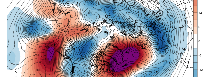
This afternoons national radar mosaic, surface temperatures, mid level temperatures, and mid level heights showing a clear southwesterly flow in place already over the East
Tuesday Into Wednesday
Tuesday morning will likely start off rather mild, with patchy fog and mostly cloudy conditions over much of the Northeast. The mid level warm front will be located well to our north over southern Canada by tomorrow morning, so the threat of rain looks rather low for tomorrow-though some patchy drizzle may be possible closer to the coast. Relatively dry air is forecast to punch into the Northeast tomorrow afternoon, which should help to burn away the vast majority of the cloud cover tomorrow afternoon. With mid level temperatures much above normal and sunny conditions in place, highs tomorrow will likely reach well into the 60’s over much of the New York metro area, with a chance at breaking into the 70’s for portions of Northeast New Jersey and locations to the south of New York City. “Cooler” highs in the lower 60’s will be possible off the north and west as well as along coastal locations due to onshore flows bringing in a more maritime airmass. While not as widespread, tomorrow will be the first day the record high temperatures could fall across the interior locations of the Northeast. Clear and mild conditions should last well into the evening and overnight hours, with southwesterly flow continuing to increase mid level temperatures. This should allow lows to be quite warm for this time of year, with many locations seeing readings stay in the lower to middle 50’s-which could potentially set record maximum low temperatures for this time of year.
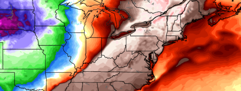
Wednesday looks to be the warmest day of the week as deep southwesterly flow is maximized over the region, bringing in highly abnormal temperatures across much of the East. The day may start off with some low clouds and fog, but dry mid levels will likely aid in the vast majority of this cloud cover burning off by the early afternoon hours. After that, temperatures will be off to the races across the entire Northeast. Widespread records may fall during the afternoon, as readings soar into the middle to upper 70’s across the Northeast. Lower readings are guaranteed over portions of coastal NJ, CT, and Long Island due to onshore flow that will bring in that maritime airmass once again. Cloud cover will then begin to increase later in the afternoon as a cold front approaches from the west, with scattered showers along it. As this front approaches, shower activity will likely be on the steady decline, so only expect broken showers through the area during the evening and overnight hours. Temperatures should fall during the overnight hours as the front passes through the region, with lows still staying 5-10 degrees above normal.
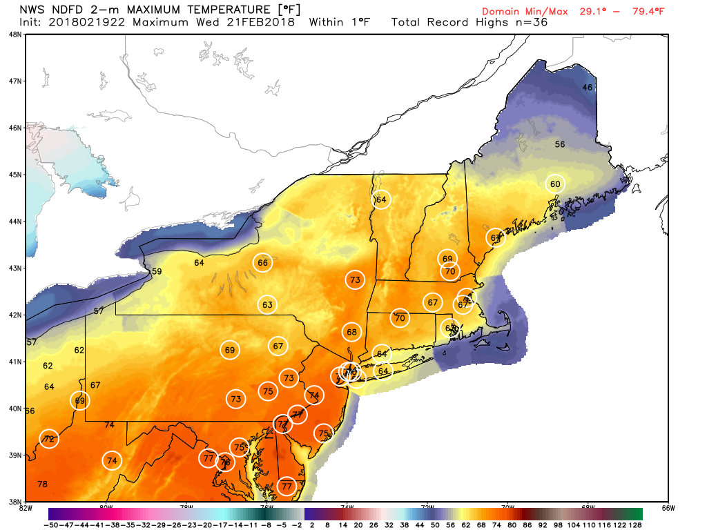
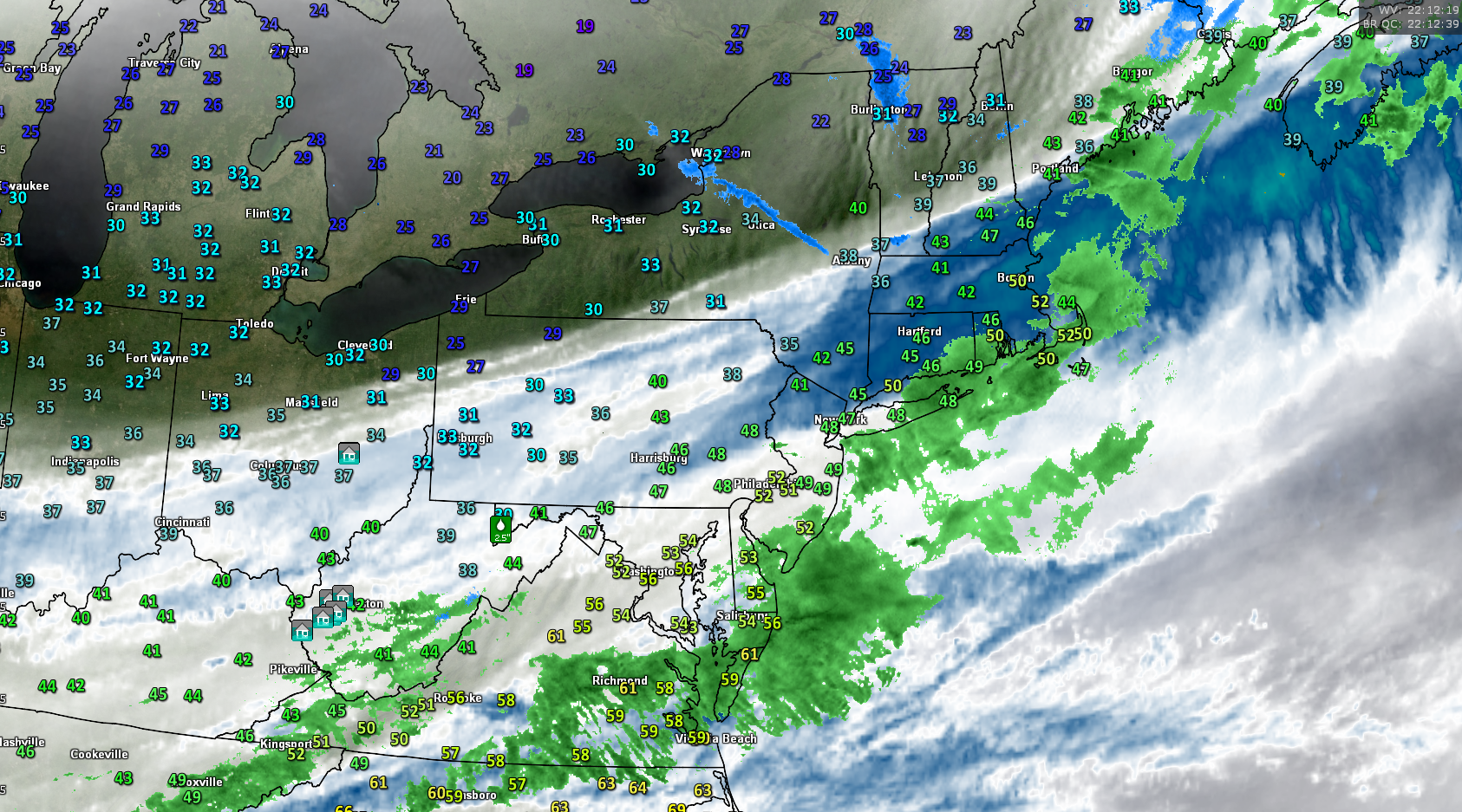
NWS forecasted highs on Wednesday with the circles representing potential records being broken
Unsettled and Mild Into the Weekend
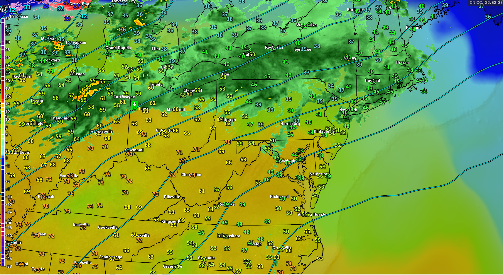
The very impressive mid level ridging over the Western Atlantic will remain in place throughout the remainder of the week, keeping conditions rather mild, with chances at light to moderate rain events. The first potential rain event looks to occur on Thursday evening as Gulf moisture streams up and around the mid level ridging and into the Northeast. A very impressive upper level jet streak also looks to be just to the north of the area, so this will likely promote the development of at least light to moderate rain over the Mid Atlantic and Northeast. The chance for rain looks to continue through the overnight hours on Thursday and into Friday, as another upper level system digs into the West. This will create yet another plume of moisture streaming north into East, with moderate rain likely over at least western portions of the Northeast. The models begin to divergence on the last rain threat over the weekend, but this afternoons European model shows a rather expansive area of rain developing over the Ohio Valley and Northeast Saturday night and lasting into Sunday. Despite the run-to-run uncertainty, the overall upper level pattern looks to be one that could support some rather widespread moderate rain over the area, with some potentially heavy showers embedded into the mix due to a favorable/peaking jet structure. Temperatures during this period look to be above-normal, but not as warm as Tuesday or Wednesday, with highs in the 40’s and 50’s. In the longer range, we may have to watch for a potential shift in the overall pattern, but we will dive into this more later in the week.
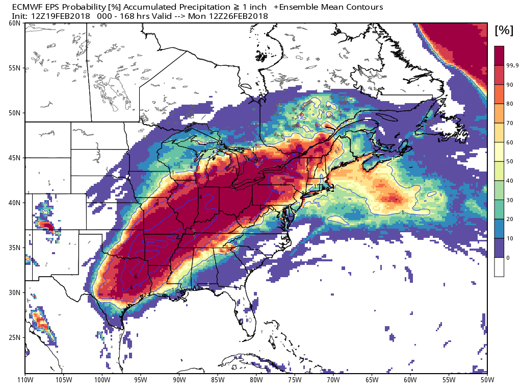
This afternoons European Ensembles showing a very wet and active pattern in the central and eastern US over the next week
Have a great night!
Steve Copertino