SPC set to add two new risk categories in 2014

The Storm Prediction Center has used the same risk categories for a large part of most of our meteorological careers. Although they have adjusted the probabilities, percentages, and yes even the colors — the categorical risk areas have remained the same. In Spring 2014, that will change. The Storm Prediction Center currently uses a simple categorical risk system which highlights the potential for severe thunderstorms across the country. The risk areas of Slight, Moderate and High are triggered by percentage chance of a type of severe weather within 25 miles of any point. And while the newer outlooks also highlight the potential for general non-severe thunderstorms across the country, Spring 2014 will mark a dramatic change in the outlooks.

The main change will be the addition of two risk levels, both falling on opposite sides of the “Slight” risk of severe thunderstorms. “Marginal”, a new risk category, will highlight the potential for severe thunderstorms that includes a 5-10″ chance of wind and hail and a 2-5% chance of tornadoes — but does not trigger a slight risk. “Enhanced” falls on the other side of “Slight”; in other words the risk levels are enhanced (30-45% risk) but not organized or widespread enough to trigger a Moderate Risk. Below, the Storm Prediction Center has released a new probability to categorical description table to help understand the changes.

The new SPC risk categories expected to be implemented in 2014.

The new SPC risk categories expected to be implemented in 2014.

Read more

SPC issues rare High Risk over Great Lakes, Ohio Valley

A major severe weather outbreak is forecast this afternoon across much of the Great Lakes and Ohio and Mississippi Valleys. The Storm Prediction Center has issued a rare “High Risk” for severe weather across much of Illinois and Indiana as well as parts of Southern Michigan and Western Ohio. A highly unstable atmosphere, juxtaposed with an impressive storm system both aloft and at the surface, will act to trigger the development of impressive late-season severe thunderstorms. Impressive low level shear and wind turning will allow for the potential of widespread tornadoes, some of which could be violent. With time, the storms will organize to pose more of a damaging wind threat as they shift eastward towards the Ohio Valley. For more on the developing threat, stay tuned to the Storm Prediction Center page which will display all outlooks, watches and warnings.

In our area, the SPC has extended a “Slight Risk” for severe weather to include all of New Jersey, New York and Connecticut. As the associated cold front sweeps through the Ohio Valley and eventually the Northeast US later today, the potential for isolated strong wind gusts is expected to continue. The threat, and intensity of the storms, is not expected to be nearly as severe as it will be back across the Great Lakes and Ohio Valley.

Storm Prediction Center Day 1 Categorical severe weather outlook from 11/17/13, showing a High Risk over parts of IL, IN and OH as well as a Slight Risk in the NYC Area.

Storm Prediction Center Day 1 Categorical severe weather outlook from 11/17/13, showing a High Risk over parts of IL, IN and OH as well as a Slight Risk in the NYC Area.

Read more

Live Thread: Tornado Watch until 5pm

Ahead of an expected severe weather threat including the potential for strong winds, the Storm Prediction Center has issued a Tornado Watch this morning for all of New Jersey, Southeast New York and the NYC Metro Area. The Tornado Watch is in effect from 9:00 am this morning until 5:00pm this afternoon.  A tornado watch means conditions are are favorable for severe thunderstorms capable of producing tornadoes in and around the watch area. Although not immediately likely, a higher than normal chance exists for gusty winds and isolated tornadoes this afternoon.

The Storm Prediction Center issued a Tornado Watch for much of the area this morning, in effect until 5:00pm. The area within the red box is included in the watch area.

The Storm Prediction Center issued a Tornado Watch for much of the area this morning, in effect until 5:00pm. The area within the red box is included in the watch area.

Earlier this morning, our article discussed the potential for severe weather this afternoon. A strong cold front approaching a very warm and moist airmass will be the focal point for the development of storms. However, more importantly, strong shear exists in multiple levels of the atmosphere near the approaching cold front. This will aid in storm organization, and amplify concern for strong winds mixing down to the surface later today. Although not likely to be widespread, an additional threat may exist for isolated tornadoes within an expected line of strong to severe storms.

Stay tuned this afternoon to this post, which will be automatically updated by our forecasters. Additionally, we will relay all additional watches and warnings via social media accounts on Facebook and Twitter.

Read more

Severe Weather Threat on Saturday: Run-of-the-Mill or Significant?

NYC sounding saturday

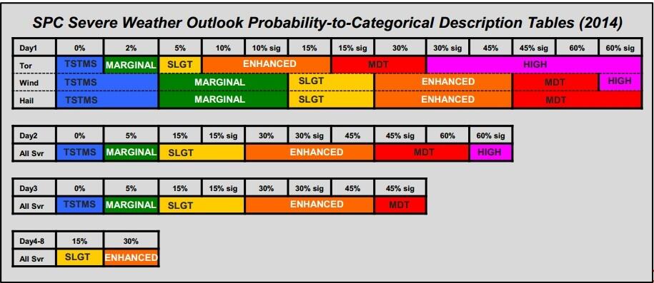
00z NAM Forecast Sounding for NYC, Valid for 5pm on Saturday.


Saturday will be the last day of our heatwave, as a strong cold front approaches the area. With strong cold fronts and very warm, moist air out ahead of them, severe weather threats often ensue, and Saturday will be no different. However, although there are some factors that support severe weather, there are plenty that do not.

A quick technical explanation as to why will be aided in illustration by the sounding above. With a strong storm system traversing southern Canada, the best dynamics — and thus, best forcing — will be located well north of the area. This also means that the strongest mid-level winds and best shear will also be located to the northwest of NYC as well. Taking a look at this sounding, you can see that the wind fields are not that impressive — which does not give very fast forward motion, helping to reduce potential wind speeds. Slower wind fields also support weaker storms, as this prevents the updraft and downdraft from sufficiently separating. The wind speeds are still fast enough for some storm survival, but nothing that is too terribly impressive.

Another thing is that there is essentially no directional shear — the wind field is pretty unidirectional. This will make any tornado threat for our area essentially negligible, and further hinders the amount of updraft and downdraft separation.

Another negative for severe weather is the very tame mid-level lapse rates. The 850mb-500mb lapse rates are only 5.8 C/KM, which is quite unimpressive. We like to see values of around 7 C/KM or greater. Poor mid-level lapse rates tend to lead to squall lines that struggle to maintain themselves, especially as the storms begin to outrun the cold front and thus outrun any dynamic forcing for ascent that there is. Further northwest, poor mid-level lapse rates won’t be as much of a problem, since any squall line can maintain itself via lift from the front; but further east, the lifting from the front is bit further removed from it, and thus weaker.

We do have very steep low-level lapse rates, as from 0-1.5km (about 850mb), they are 9.6 C/KM, which is nearly dry-adibatic. This provides steep low-level instability — and combining this with high heat and humidity — provides good surface-based CAPE of nearly 2000 J/KG. This will help to provide some lift and good, healthy updrafts. Additionally, the steep low-level lapse rates help to provide lots of downward momentum, or negative buoyancy, for any downdrafts. This could help lead to some damaging winds in any strong downdraft, and I suspect that this will be the main severe weather threat. The relatively dry mid-levels could also lead to a threat of hail as well, but this would also be isolated and mainly relegated to the north, west, and northwest as well, since mid-level lift may not be strong enough to generate the very high cloud tops for hail in the NYC area.

Regardless — although the above paragraph does lend some credence to a wind threat, the fact that by evening, the main convective mode may be lines and clusters may mean that the mid-level lapse rates being poor will outweigh the low-level lapse rates being favorable, especially further east and away from the best forcing. So, although some isolated severe wind may be in the cards for Saturday — the best, widespread severe wind threat will definitely be well to the north, west, and northwest of the area, in our opinion. Things could change, and of course, we will keep you posted.