Tuesday Overview: Warm, Dry Conditions Lead to Brush Fire Danger

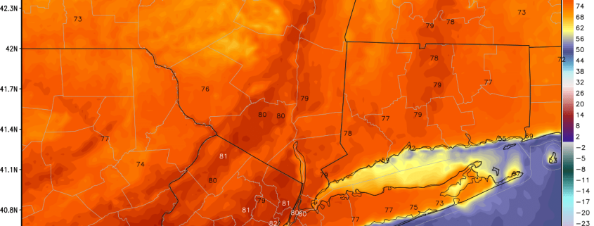
After a taste of early summer yesterday–with temperatures in the lower 80s in parts of the area–somewhat cooler temperatures are in store for today. A cold front has passed through much region with some clouds, early this morning. Partly sunny skies are anticipated for the rest of day with somewhat cooler airmass behind the front. However, northwest downsloping winds behind the cold are already causing temperatures to rise into upper 60s and lower 70s over the region. These warm temperatures will continue this afternoon, perhaps rising into the middle 70s is some spots.

Read more

Monday Overview: Pleasant, Warm Weather Continues Into This Week

After an unseasonably chilly weather to begin April, more spring-like weather has arrived for region over this past weekend. Pleasant weather will continue much of this week. A cold front will moving south through the local region late tonight or Tuesday morning. Model guidance shows this front will most likely come through the region dry, with moisture very limited and best forcing well north and east of the region. The next chance of any rainfall of consequence will come late Thursday night and Friday.

Read more

Monday Musings: Warmer, unsettled, cutoff low

So far, Spring 2016 has been absent, despite calendar arguing otherwise. The trend looks to continue this week, and as we look forward into the medium range, forecast models suggest it may continue even further into next weekend. While we aren’t quite looking at snow, the weather looks likely to be cooler than normal — all thanks to an unsettled pattern through midweek, and then a cutoff low which may impact the area thereafter. The story begins on Monday, as a southwesterly flow brings increasing clouds and the potential for showers.

A frontal system will swing through the area on Tuesday, with a period of steady rain possible along the frontal boundary. While the end of the week may be warmer and drier, the potential for a cutoff low exists later this weekend. This idea gains credence given the presence of high latitude blocking, extending essentially from Greenland into the Western Atlantic Ocean, acting like a “wall” to prevent any disturbances from escaping. But, more on that later. Here are the highlights to start the week:

Read more

(Premium) Dynamic cooling may bring snow to some on Saturday

While the calendar has pointed to Spring for several days, the weather pattern has not cooperated. This weekend will be no exception. Forecast models have come into better agreement over the past few days regarding the eventual development of a low pressure system off the Mid Atlantic coast, which will form as a result of a powerful mid level atmospheric disturbance dropping southward from Canada into the Great Lakes and Northeast.

A low pressure system is likely to develop from the Ohio Valley into the Mid Atlantic and off the coast of New Jersey. Precipitation is likely to develop on the northern end of the storm system, as moisture pushes northward from the low pressure area. This will allow for bands of precipitation to develop towards our area, likely falling as rain. The antecedent airmass is quite warm, and likely supports rain over any frozen precipitation, with melting of snowflakes occurring in the lower levels of the atmosphere. However, there is one main caveat in the setup: The potential for intense banding and dynamic cooling, producing heavy snow over some areas.

Read more